TransIberia 20. Santa Cruz de Guarda-Mangualde.

MTB
MTB
Ref..: 25769
Published: 18/05/2015
Performed: 30/04/2015
Distance in Km: 78.61
Climb in m: 2079
IBP: 156 BYC

zinaztli
Author: zinaztli
480 published routes

Add to my Group or Club


Varios dias

This route belongs to a multi-day journey 23 days documented with 23 independent routes

You can download the tracks of this multi-day route from each of the associated stages .
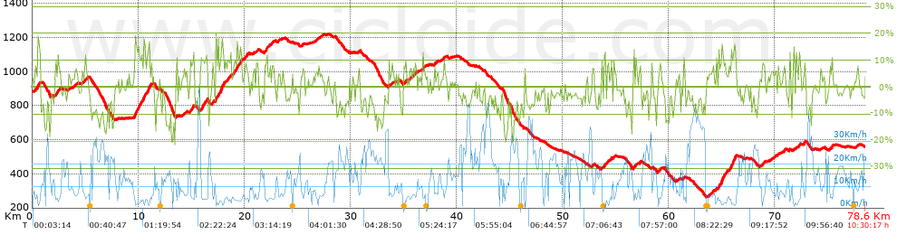
 Day or stage  One day stage  Distance  Climb in  IBP
 Day 1  25750 TransIberia 01. Valencia-Sagunto.  53 Km  80 m  20
 Day 2  25751 TransIberia 02. Sagunto-Bejís.  78 Km  2305 m  159
 Day 3  25752 TransIberia 03. Bejís-Ademuz.  89 Km  2117 m  146
 Day 4  25753 TransIberia 04. Ademuz-Nacimiento del Tajo.  73 Km  2183 m  137
 Day 5  25754 TransIberia 05. Nacimiento del Tajo-Peralejos de las Truchas.  68 Km  1361 m  87
 Day 6  25755 TransIberia 06. Peralejos de las Truchas-Abánades (Las Cruces).  95 Km  1830 m  122
 Day 7  25756 TransIberia 07. Abánades (Las Cruces)-Jadraque.  66 Km  952 m  69
 Day 8  25757 TransIberia 08. Jadraque-La Vereda.  58 Km  1528 m  101
 Day 9  25758 TransIberia 09. La Vereda-Puerto de Somosierra.  46 Km  1446 m  91
 Day 10  25759 TransIberia 10. Puerto de Somosierra-La Granja de San Ildefonso.  97 Km  1615 m  112
 Day 11  25760 TransIberia 11. La Granja de San Ildefonso-Robledo de Chavela (Matarrubia).  65 Km  1838 m  119
 Day 12  25761 TransIberia 12. Robledo de Chavela (Matarrubia)-Navaluenga.  81 Km  1551 m  116
 Day 13  25762 TransIberia 13. Navaluenga-Hoyos del Espino.  67 Km  2088 m  144
 Day 14  25763 TransIberia 14. Hoyos del Espino-Béjar.  80 Km  1599 m  102
 Day 15  25764 TransIberia 15. Béjar-Miranda del Castañar.  40 Km  895 m  75
 Day 16  25765 TransIberia 16. Miranda del Castañar-La Alberca.  16 Km  713 m  64
 Day 17  25766 TransIberia 17. La Alberca-Serradilla del Llano.  36 Km  872 m  60
 Day 18  25767 TransIberia 18. Serradilla del Llano-Navasfrías.  71 Km  1411 m  88
 Day 19  25768 TransIberia 19. Navasfrías-Santa Cruz de Guarda.  68 Km  1721 m  124
 Day 20  25769 TransIberia 20. Santa Cruz de Guarda-Mangualde. (This)  79 Km  2079 m  156
 Day 21  25770 TransIberia 21. Mangualde-Sao Pedro do Sul (Termas).  67 Km  1305 m  98
 Day 22  25771 TransIberia 22. Sao Pedro do Sul (Termas)-Arouca.  55 Km  1921 m  142
 Day 23  25772 TransIberia 23. Arouca-Oporto.  83 Km  1558 m  114
 Total 23 days  1531 Km  34968 m  106 / día

 Height in m      Climb in %      Speed in Km/h      Speed < 2 Km/h


Description of the route


Presence of ramps


 Climbs  Distance  % of the total  Speed  Your speed would be  Time  Your time would be
   15 - 30%  1.151  1.46  3.27  ?  0:21:09  ?
   10 - 15%  5.475  6.96  4.76  ?  1:09:02  ?
   5 - 10%  10.911  13.88  6.1  ?  1:47:19  ?
   1 - 5%  14.535  18.49  8.74  ?  1:39:44  ?
   Total*  32.072 Km  40.8 %  6.47 Km/h  ? Km/h    4:57:14 h  ? h  
 Flat
   1 - -1%  8.82 Km  11.22 %  11.51 Km/h  ? Km/h    0:45:58 h  ? h  
 Descents
   -1 - -5%  17.946  22.83  15.61  ?  1:09:00  ?
   -5 - -10%  12.78  16.26  19  ?  0:40:21  ?
   -10 - -15%  5.162  6.57  18.57  ?  0:16:41  ?
   -15 - -30%  1.826  2.32  14.17  ?  0:07:44  ?
   Total*  37.714 Km  47.98 %  16.92 Km/h  ? Km/h    2:13:46 h  ? h  
* The total has not necessarily coincide with the sum of the partials after correction of errors

How long would it take you?

How long would it take you to cover this route?
There are routes without a valid time information, but with your average stats you can assess the possible duration

zinaztli to cover this route you've need a time of:   7:56:58 h 
If you sign in and have a minimum of two tracks of this same modality, you can know your time for this route, calculated from your stats..


¿Cuanto consumirá tu E-BIKE?

Entra tu E-IBP (formato n,nn)

E-IBP :   X 156 = 


 Detected activity type =  ()
 Penalization due to track conditions: 73 %   ( > 50 % = MTB, < 50 % = RDB)
 Reliability of the track: A   (2078/72/0/-/-/72)
 Correction level applied to the track: 0
DIFFICULTY OF THE ROUTE
IBP = 156 BYC
According to your statistics
 Your time in motion would be: ? h
Your average speed would be: ? Km/h
 

 Total Distance: 78.61 Km
 Analysed distance: 78.61 Km
 Linear distance: 44.58 Km

 Cumulated positive ramps: 2078.91 m  list of points info
 Cumulated negative ramps: 2393.75 m
 Maximum height: 1218.61 m
 Minimum height: 263.54 m
 Climbing Ratio: 6.48 %
 Descent ratio: 6.35 %
 Cumulated postive ramps per Km: 26.45 m
 Cumulated negative ramps per Km: 30.45 m

 Total time: 10:30:17 h
 Time in movement: 7:56:58 h
 According to your statistics
 Your time in motion would be: ? h  
 Stopped time: 2:33:19 h
 Maximum slope filter: ~30 %
 Minimum separation analysed: ~30 m
 Number of points: 2683   (cad. 29.3 m)
 Significant waypoints: 1687   (cad. 46.6 m / 62.88 %)

 Changes in direction per Km: 9.1
 Changes in direction > 5º por Km: 7.06
 Cumulated straight stretches: 11.239 Km
 Straight stretches per Km: 142.97 m
 Penalized slope changes: 22
 Penalized slope changes per Km: 0.28

 Average speed in total: 7.48 Km/h
 Average speed while moving: 9.89 Km/h
 According to your statistics
 Your average speed would be: ? Km/h  
 Maximum sustained speed: 55.73 Km/h


Comments

You can be the first one in commenting this route

 
My comments
:
Add comment  (Registered users)
 
Notify me answers to my comment  Do not notify answers to my comment


Share this route with a friend

Your friend will receive a message with a link to this page:
will see your email and your user name if you do it as registered user.


Write here your name (optional)

E-mail address of your friend(s). You can include various addresses separated by commas

Text or comment (optional) maximum 255 characters long, 255 Available characters

As a non registered users you need to fill-in the captcha text.
  Change image
Type the image characters.
 
 Share with a friend


Visited history

Delete history

Marked routes for review later or compare

My favorites


  Notify anomaly in this route Share in Facebook