Maraton BTT Aznalcollar 2015

MTB
MTB
Ref..: 24574
Published: 04/05/2015
Performed: 18/04/2015
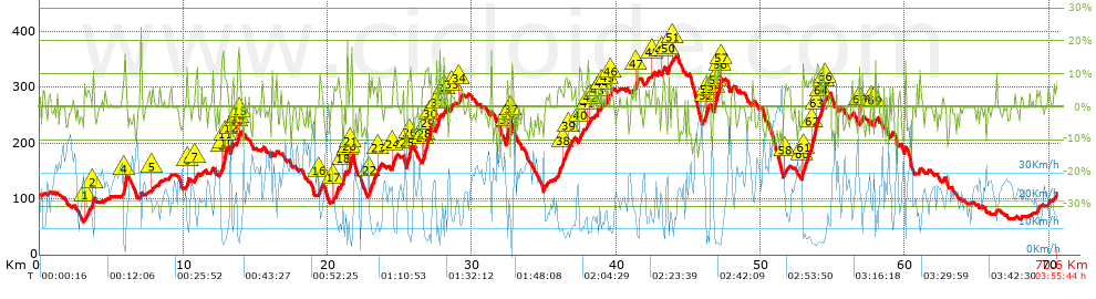
Distance in Km: 70.59
Climb in m: 1623
IBP: 131 BYC


 Height in m      Climb in %      Speed in Km/h      Speed < 2 Km/h

Climbs > 5%

Climbs >5% Climbs >10% Climbs >15% Climbs >20% Climbs >25%
 Steep slope of 113 m.   Average slope  Distances  Download as waypoint
1
 Km 3.125  5%  113 m
 Steep slope of 108 m.  Average slope  Distances  Download as waypoint
2
 Km 3.677  12%  108 m
 Steep slope of 195 m.  Average slope  Distances  Download as waypoint
3
 Km 5.823  9%  33 m
4
 Km 5.856  17%  162 m
 Steep slope of 98 m.  Average slope  Distances  Download as waypoint
5
 Km 7.798  6%  98 m
 Steep slope of 99 m.  Average slope  Distances  Download as waypoint
6
 Km 10.231  15%  99 m
 Steep slope of 153 m.  Average slope  Distances  Download as waypoint
7
 Km 10.773  5%  153 m
 Steep slope of 365 m.  Average slope  Distances  Download as waypoint
8
 Km 12.633  5%  95 m
9
 Km 12.728  17%  30 m
10
 Km 12.758  15%  97 m
11
 Km 12.854  10%  143 m
 Steep slope of 103 m.  Average slope  Distances  Download as waypoint
12
 Km 13.315  9%  103 m
 Steep slope of 244 m.  Average slope  Distances  Download as waypoint
13
 Km 13.713  6%  34 m
14
 Km 13.747  9%  97 m
15
 Km 13.844  9%  113 m
 Steep slope of 171 m.  Average slope  Distances  Download as waypoint
16
 Km 19.4  8%  171 m
 Steep slope of 296 m.  Average slope  Distances  Download as waypoint
17
 Km 20.407  6%  296 m
 Steep slope of 128 m.  Average slope  Distances  Download as waypoint
18
 Km 21.058  14%  128 m
 Steep slope of 351 m.  Average slope  Distances  Download as waypoint
19
 Km 21.339  8%  126 m
20
 Km 21.464  8%  132 m
21
 Km 21.596  18%  93 m
 Steep slope of 379 m.  Average slope  Distances  Download as waypoint
22
 Km 22.849  8%  379 m
 Steep slope of 236 m.  Average slope  Distances  Download as waypoint
23
 Km 23.513  6%  236 m
 Steep slope of 266 m.  Average slope  Distances  Download as waypoint
24
 Km 24.461  8%  266 m
 Steep slope of 295 m.  Average slope  Distances  Download as waypoint
25
 Km 25.45  8%  234 m
26
 Km 25.684  15%  61 m
 Steep slope of 673 m.  Average slope  Distances  Download as waypoint
27
 Km 26.526  6%  149 m
28
 Km 26.675  10%  222 m
29
 Km 26.897  9%  154 m
30
 Km 27.051  11%  148 m
 Steep slope of 277 m.  Average slope  Distances  Download as waypoint
31
 Km 27.524  8%  277 m
 Steep slope of 206 m.  Average slope  Distances  Download as waypoint
32
 Km 28.025  6%  206 m
 Steep slope of 104 m.  Average slope  Distances  Download as waypoint
33
 Km 28.578  7%  104 m
 Steep slope of 156 m.  Average slope  Distances  Download as waypoint
34
 Km 29.079  6%  156 m
 Steep slope of 190 m.  Average slope  Distances  Download as waypoint
35
 Km 32.355  12%  133 m
36
 Km 32.488  22%  57 m
 Steep slope of 155 m.  Average slope  Distances  Download as waypoint
37
 Km 32.651  8%  155 m
 Steep slope of 262 m.  Average slope  Distances  Download as waypoint
38
 Km 36.272  7%  262 m
 Steep slope of 205 m.  Average slope  Distances  Download as waypoint
39
 Km 36.641  6%  205 m
 Steep slope of 253 m.  Average slope  Distances  Download as waypoint
40
 Km 37.444  7%  253 m
 Steep slope of 127 m.  Average slope  Distances  Download as waypoint
41
 Km 37.924  6%  127 m
 Steep slope of 106 m.  Average slope  Distances  Download as waypoint
42
 Km 38.161  6%  106 m
 Steep slope of 133 m.  Average slope  Distances  Download as waypoint
43
 Km 38.65  8%  133 m
 Steep slope of 154 m.  Average slope  Distances  Download as waypoint
44
 Km 38.908  5%  154 m
 Steep slope of 125 m.  Average slope  Distances  Download as waypoint
45
 Km 39.325  6%  125 m
 Steep slope of 131 m.  Average slope  Distances  Download as waypoint
46
 Km 39.564  6%  131 m
 Steep slope of 221 m.  Average slope  Distances  Download as waypoint
47
 Km 41.367  8%  221 m
 Steep slope of 104 m.  Average slope  Distances  Download as waypoint
48
 Km 42.479  5%  104 m
 Steep slope of 234 m.  Average slope  Distances  Download as waypoint
49
 Km 43.159  6%  234 m
 Steep slope of 225 m.  Average slope  Distances  Download as waypoint
50
 Km 43.571  7%  225 m
 Steep slope of 102 m.  Average slope  Distances  Download as waypoint
51
 Km 43.899  8%  102 m
 Steep slope of 336 m.  Average slope  Distances  Download as waypoint
52
 Km 46.188  12%  121 m
53
 Km 46.309  9%  215 m
 Steep slope of 539 m.  Average slope  Distances  Download as waypoint
54
 Km 46.772  13%  94 m
55
 Km 46.866  9%  266 m
56
 Km 47.132  14%  103 m
57
 Km 47.235  7%  76 m
 Steep slope of 107 m.  Average slope  Distances  Download as waypoint
58
 Km 51.691  7%  107 m
 Steep slope of 1195 m.  Average slope  Distances  Download as waypoint
59
 Km 52.859  8%  36 m
60
 Km 52.895  13%  98 m
61
 Km 52.993  7%  617 m
62
 Km 53.611  11%  303 m
63
 Km 53.913  9%  141 m
 Steep slope of 345 m.  Average slope  Distances  Download as waypoint
64
 Km 54.15  8%  178 m
65
 Km 54.328  11%  98 m
66
 Km 54.426  5%  69 m
 Steep slope of 183 m.  Average slope  Distances  Download as waypoint
67
 Km 56.841  6%  183 m
 Steep slope of 106 m.  Average slope  Distances  Download as waypoint
68
 Km 57.621  8%  106 m
 Steep slope of 91 m.  Average slope  Distances  Download as waypoint
69
 Km 57.904  12%  91 m


Description of the route


Presence of ramps


 Climbs  Distance  % of the total  Speed  Your speed would be  Time  Your time would be
   15 - 30%  1.026  1.45  5.73  ?  0:10:45  ?
   10 - 15%  3.612  5.12  8.48  ?  0:25:34  ?
   5 - 10%  9.8  13.88  11.07  ?  0:53:08  ?
   1 - 5%  10.079  14.28  16.13  ?  0:37:29  ?
   Total*  24.516 Km  34.73 %  11.59 Km/h  ? Km/h    2:06:56 h  ? h  
 Flat
   1 - -1%  19.396 Km  27.48 %  21.79 Km/h  ? Km/h    0:53:25 h  ? h  
 Descents
   -1 - -5%  11.782  16.69  27.63  ?  0:25:35  ?
   -5 - -10%  10.955  15.52  31.42  ?  0:20:55  ?
   -10 - -15%  3.494  4.95  38.23  ?  0:05:29  ?
   -15 - -30%  0.452  0.64  35.4  ?  0:00:46  ?
   Total*  26.682 Km  37.8 %  30.35 Km/h  ? Km/h    0:52:45 h  ? h  
* The total has not necessarily coincide with the sum of the partials after correction of errors

How long would it take you?

How long would it take you to cover this route?
There are routes without a valid time information, but with your average stats you can assess the possible duration

Diego del Pino to cover this route you've need a time of:   3:53:06 h 
If you sign in and have a minimum of two tracks of this same modality, you can know your time for this route, calculated from your stats..


¿Cuanto consumirá tu E-BIKE?

Entra tu E-IBP (formato n,nn)

E-IBP :   X 131 = 


 Detected activity type =  ()
 Penalization due to track conditions: 77 %   ( > 50 % = MTB, < 50 % = RDB)
 Reliability of the track: B   (1624/59/0/-/-/59)
 Correction level applied to the track: 0
DIFFICULTY OF THE ROUTE
IBP = 131 BYC
According to your statistics
 Your time in motion would be: ? h
Your average speed would be: ? Km/h
 

 Total Distance: 70.59 Km
 Analysed distance: 70.59 Km
 Linear distance: 0.16 Km

 Cumulated positive ramps: 1623.3 m  list of points info
 Cumulated negative ramps: 1621 m
 Maximum height: 357 m
 Minimum height: 59 m
 Climbing Ratio: 6.62 %
 Descent ratio: 6.08 %
 Cumulated postive ramps per Km: 23 m
 Cumulated negative ramps per Km: 22.96 m

 Total time: 3:55:44 h
 Time in movement: 3:53:06 h
 According to your statistics
 Your time in motion would be: ? h  
 Stopped time: 0:02:38 h
 Maximum slope filter: ~30 %
 Minimum separation analysed: ~30 m
 Number of points: 3443   (cad. 20.5 m)
 Significant waypoints: 1687   (cad. 41.85 m / 49 %)

 Changes in direction per Km: 9.92
 Changes in direction > 5º por Km: 7.44
 Cumulated straight stretches: 10.333 Km
 Straight stretches per Km: 146.38 m
 Penalized slope changes: 15
 Penalized slope changes per Km: 0.212

 Average speed in total: 17.97 Km/h
 Average speed while moving: 18.17 Km/h
 According to your statistics
 Your average speed would be: ? Km/h  
 Maximum sustained speed: 60.15 Km/h


Comments

You can be the first one in commenting this route

 
My comments
:
Add comment  (Registered users)
 
Notify me answers to my comment  Do not notify answers to my comment


Share this route with a friend

Your friend will receive a message with a link to this page:
will see your email and your user name if you do it as registered user.


Write here your name (optional)

E-mail address of your friend(s). You can include various addresses separated by commas

Text or comment (optional) maximum 255 characters long, 255 Available characters

As a non registered users you need to fill-in the captcha text.
  Change image
Type the image characters.
 
 Share with a friend


Visited history

Delete history

Marked routes for review later or compare

My favorites


  Notify anomaly in this route Share in Facebook