Pedals del Cister Btteros 2015 dia 1

MTB
MTB
Ref..: 21972
Published: 31/03/2015
Performed: 28/03/2015
Distance in Km: 98.6
Climb in m: 2296
IBP: 155 BYC

Near ...
Altafulla, Ardenya, Casas De Virgili, Ferran, Nou De Gaia, La, Riera De Gaia, La

 Height in m      Climb in %      Speed in Km/h      Speed < 2 Km/h

Climbs > 5%

Climbs >5% Climbs >10% Climbs >15% Climbs >20% Climbs >25%
 Steep slope of 197 m.   Average slope  Distances  Download as waypoint
1
 Km 0.162  6%  197 m
 Steep slope of 517 m.  Average slope  Distances  Download as waypoint
2
 Km 1.937  6%  517 m
 Steep slope of 175 m.  Average slope  Distances  Download as waypoint
3
 Km 4.042  6%  175 m
 Steep slope of 266 m.  Average slope  Distances  Download as waypoint
4
 Km 4.652  8%  266 m
 Steep slope of 226 m.  Average slope  Distances  Download as waypoint
5
 Km 5.773  5%  226 m
 Steep slope of 341 m.  Average slope  Distances  Download as waypoint
6
 Km 6.967  6%  341 m
 Steep slope of 252 m.  Average slope  Distances  Download as waypoint
7
 Km 9.211  6%  252 m
 Steep slope of 601 m.  Average slope  Distances  Download as waypoint
8
 Km 11.527  8%  261 m
9
 Km 11.788  13%  340 m
 Steep slope of 179 m.  Average slope  Distances  Download as waypoint
10
 Km 12.478  6%  179 m
 Steep slope of 283 m.  Average slope  Distances  Download as waypoint
11
 Km 22.072  7%  283 m
 Steep slope of 168 m.  Average slope  Distances  Download as waypoint
12
 Km 26.902  7%  168 m
 Steep slope of 313 m.  Average slope  Distances  Download as waypoint
13
 Km 28.362  6%  313 m
 Steep slope of 684 m.  Average slope  Distances  Download as waypoint
14
 Km 30.851  6%  684 m
 Steep slope of 198 m.  Average slope  Distances  Download as waypoint
15
 Km 33.597  6%  198 m
 Steep slope of 236 m.  Average slope  Distances  Download as waypoint
16
 Km 34.055  6%  236 m
 Steep slope of 260 m.  Average slope  Distances  Download as waypoint
17
 Km 34.605  7%  260 m
 Steep slope of 259 m.  Average slope  Distances  Download as waypoint
18
 Km 35.196  7%  259 m
 Steep slope of 236 m.  Average slope  Distances  Download as waypoint
19
 Km 35.857  5%  236 m
 Steep slope of 212 m.  Average slope  Distances  Download as waypoint
20
 Km 36.918  5%  212 m
 Steep slope of 865 m.  Average slope  Distances  Download as waypoint
21
 Km 37.806  9%  865 m
 Steep slope of 146 m.  Average slope  Distances  Download as waypoint
22
 Km 39.184  8%  146 m
 Steep slope of 377 m.  Average slope  Distances  Download as waypoint
23
 Km 39.531  8%  377 m
 Steep slope of 256 m.  Average slope  Distances  Download as waypoint
24
 Km 41.379  8%  256 m
 Steep slope of 964 m.  Average slope  Distances  Download as waypoint
25
 Km 42.551  7%  256 m
26
 Km 42.807  12%  708 m
 Steep slope of 1432 m.  Average slope  Distances  Download as waypoint
27
 Km 44.087  7%  508 m
28
 Km 44.596  12%  48 m
29
 Km 44.643  16%  509 m
30
 Km 45.152  12%  42 m
31
 Km 45.194  9%  325 m
 Steep slope of 483 m.  Average slope  Distances  Download as waypoint
32
 Km 45.85  7%  483 m
 Steep slope of 145 m.  Average slope  Distances  Download as waypoint
33
 Km 46.457  6%  145 m
 Steep slope of 674 m.  Average slope  Distances  Download as waypoint
34
 Km 51.749  6%  535 m
35
 Km 52.283  13%  139 m
 Steep slope of 196 m.  Average slope  Distances  Download as waypoint
36
 Km 53.187  10%  161 m
37
 Km 53.348  14%  35 m
 Steep slope of 526 m.  Average slope  Distances  Download as waypoint
38
 Km 54.157  8%  526 m
 Steep slope of 1134 m.  Average slope  Distances  Download as waypoint
39
 Km 54.971  6%  671 m
40
 Km 55.642  14%  278 m
41
 Km 55.92  7%  185 m
 Steep slope of 573 m.  Average slope  Distances  Download as waypoint
42
 Km 56.224  6%  298 m
43
 Km 56.522  14%  275 m
 Steep slope of 390 m.  Average slope  Distances  Download as waypoint
44
 Km 57.535  8%  390 m
 Steep slope of 213 m.  Average slope  Distances  Download as waypoint
45
 Km 63.124  6%  213 m
 Steep slope of 239 m.  Average slope  Distances  Download as waypoint
46
 Km 64.417  6%  239 m
 Steep slope of 476 m.  Average slope  Distances  Download as waypoint
47
 Km 65.08  5%  476 m
 Steep slope of 244 m.  Average slope  Distances  Download as waypoint
48
 Km 66.451  6%  244 m
 Steep slope of 87 m.  Average slope  Distances  Download as waypoint
49
 Km 76.56  6%  87 m
 Steep slope of 758 m.  Average slope  Distances  Download as waypoint
50
 Km 78.009  8%  271 m
51
 Km 78.28  15%  181 m
52
 Km 78.46  14%  85 m
53
 Km 78.546  6%  221 m
 Steep slope of 1256 m.  Average slope  Distances  Download as waypoint
54
 Km 79.833  6%  1256 m
 Steep slope of 662 m.  Average slope  Distances  Download as waypoint
55
 Km 83.148  7%  50 m
56
 Km 83.199  13%  612 m
 Steep slope of 266 m.  Average slope  Distances  Download as waypoint
57
 Km 84.502  9%  266 m
 Steep slope of 220 m.  Average slope  Distances  Download as waypoint
58
 Km 86.631  8%  220 m
 Steep slope of 174 m.  Average slope  Distances  Download as waypoint
59
 Km 90.704  6%  174 m


Description of the route


Presence of ramps


 Climbs  Distance  % of the total  Speed  Your speed would be  Time  Your time would be
   15 - 30%  0.779  0.79  3.42  ?  0:13:41  ?
   10 - 15%  2.923  2.96  4.71  ?  0:37:15  ?
   5 - 10%  15.615  15.84  7.39  ?  2:06:48  ?
   1 - 5%  26.814  27.19  10.72  ?  2:30:03  ?
   Total*  46.13 Km  46.78 %  8.44 Km/h  ? Km/h    5:27:47 h  ? h  
 Flat
   1 - -1%  13.048 Km  13.23 %  14.59 Km/h  ? Km/h    0:53:40 h  ? h  
 Descents
   -1 - -5%  25.618  25.98  20.36  ?  1:15:29  ?
   -5 - -10%  11.223  11.38  20.49  ?  0:32:52  ?
   -10 - -15%  2.645  2.68  13.01  ?  0:12:12  ?
   -15 - -30%  0.358  0.36  19.25  ?  0:01:07  ?
   Total*  39.845 Km  40.41 %  19.65 Km/h  ? Km/h    2:01:40 h  ? h  
* The total has not necessarily coincide with the sum of the partials after correction of errors

How long would it take you?

How long would it take you to cover this route?
There are routes without a valid time information, but with your average stats you can assess the possible duration

PedroMerida to cover this route you've need a time of:   8:23:07 h 
If you sign in and have a minimum of two tracks of this same modality, you can know your time for this route, calculated from your stats..


¿Cuanto consumirá tu E-BIKE?

Entra tu E-IBP (formato n,nn)

E-IBP :   X 155 = 


 Detected activity type =  ()
 Penalization due to track conditions: 62 %   ( > 50 % = MTB, < 50 % = RDB)
 Reliability of the track: D   (2747/46/1/4/-/72)
 Correction level applied to the track: 3        
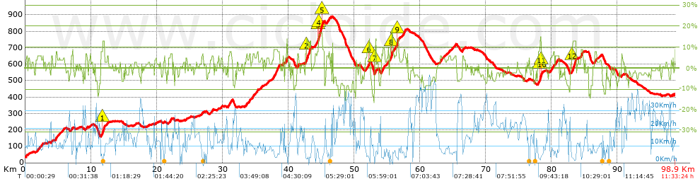
See analyis without corrections
DIFFICULTY OF THE ROUTE
IBP = 155 BYC
According to your statistics
 Your time in motion would be: ? h
Your average speed would be: ? Km/h
 

 Total Distance: 98.61 Km
 Analysed distance: 98.61 Km
 Linear distance: 33.39 Km

 Cumulated positive ramps: 2295.79 m  list of points info
 Cumulated negative ramps: 1896.57 m
 Maximum height: 889.75 m
 Minimum height: 32.91 m
 Climbing Ratio: 4.98 %
 Descent ratio: 4.76 %
 Cumulated postive ramps per Km: 23.28 m
 Cumulated negative ramps per Km: 19.23 m

 Total time: 11:33:24 h
 Time in movement: 8:23:07 h
 According to your statistics
 Your time in motion would be: ? h  
 Stopped time: 3:10:17 h
 Maximum slope filter: ~30 %
 Minimum separation analysed: ~30 m
 Number of points: 6765   (cad. 14.58 m)
 Significant waypoints: 2230   (cad. 44.42 m / 32.96 %)

 Changes in direction per Km: 9.59
 Changes in direction > 5º por Km: 7.83
 Cumulated straight stretches: 16.146 Km
 Straight stretches per Km: 163.74 m
 Penalized slope changes: 21
 Penalized slope changes per Km: 0.213

 Average speed in total: 8.53 Km/h
 Average speed while moving: 11.76 Km/h
 According to your statistics
 Your average speed would be: ? Km/h  
 Maximum sustained speed: 51.75 Km/h


Comments

You can be the first one in commenting this route

 
My comments
:
Add comment  (Registered users)
 
Notify me answers to my comment  Do not notify answers to my comment


Share this route with a friend

Your friend will receive a message with a link to this page:
will see your email and your user name if you do it as registered user.


Write here your name (optional)

E-mail address of your friend(s). You can include various addresses separated by commas

Text or comment (optional) maximum 255 characters long, 255 Available characters

As a non registered users you need to fill-in the captcha text.
  Change image
Type the image characters.
 
 Share with a friend


Visited history

Delete history

Marked routes for review later or compare

My favorites


  Notify anomaly in this route Share in Facebook