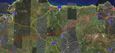
Camino Primitivo De Santiago (Etapa 1)

MTB
Ref..: 1990
Published: 11/10/2007
Performed: 01/09/2007
Distance in Km: 29.12
Climb in m: 649
IBP: 50 BYC
Drawn route
 Not from STRAVA
Near ...
Abuli, Ajuyan, Arenales, Arquera, La (Oviedo), Atrollo, El, Barraca, La (Oviedo)
Abuli, Ajuyan, Arenales, Arquera, La (Oviedo), Atrollo, El, Barraca, La (Oviedo)
 No activities
This route belongs to a multi-day journey 7 days documented with 7 independent routes
You can download the tracks of this multi-day route from each of the associated stages .| Day or stage | One day stage | Distance | Climb in | IBP |
| Day 1 | 1990 Camino Primitivo De Santiago (Etapa 1) (This) | 29 Km | 657 m | 43 |
| Day 2 | 1991 Camino Primitivo De Santiago (Etapa 2) | 40 Km | 1218 m | 72 |
| Day 3 | 1992 Camino Primitivo De Santiago (Etapa 3) | 55 Km | 1686 m | 96 |
| Day 4 | 1993 Camino Primitivo De Santiago (Etapa 4) | 45 Km | 1333 m | 70 |
| Day 5 | 1994 Camino Primitivo De Santiago (Etapa 5) | 52 Km | 1028 m | 61 |
| Day 6 | 1995 Camino Primitivo De Santiago (Etapa 6) | 61 Km | 1152 m | 68 |
| Day 7 | 1996 Camino Primitivo De Santiago (Etapa 7) | 39 Km | 675 m | 51 |
| Total 7 days | 321 Km | 7749 m | 66 / dﻥa |


 list of points info

