Camino de Santiago. Etapa 15: Palas de Rei-Santiago de Compostela

MTB
MTB
Ref..: 19843
Published: 26/10/2014
Performed: 05/07/2014
Distance in Km: 70.66
Climb in m: 1233
IBP: 96 BYC

Near ...
Carballal (San Mamede), Cuiña (Santa Maria) (Palas De Rei), Filgueira, Marza, Quindimil, Vilareda
Rodri63
Author: Rodri63
73 published routes

Add to my Group or Club


Varios dias

This route belongs to a multi-day journey 15 days documented with 15 independent routes

You can download the tracks of this multi-day route from each of the associated stages .
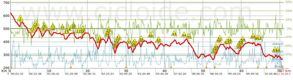
 Day or stage  One day stage  Distance  Climb in  IBP
 Day 1  19845 Camino de Santiago. Etapa 1 Sant Joan Despí-Jorba  93 Km  1765 m  147
 Day 2  19846 Camino de Santiago. Etapa 2: Jorba-Algerri  100 Km  887 m  89
 Day 3  19847 Camino de Santiago. Etapa 3: Algerri-Pueyo de Farfañás  97 Km  888 m  87
 Day 4  19849 Camino de Santiago. Etapa 4: Pueyo de Farfañás-Loarre  56 Km  842 m  62
 Day 5  19878 Camino de Santiago. Etapa 5. Loarre-Santa Cruz de la Serós  60 Km  1407 m  113
 Day 6  19880 Camino de Santiago. Etapa 6. Santa Cruz de la Serós-Sangüesa  70 Km  1009 m  90
 Day 7  19881 Camino de Santiago. Etapa 7. Sangüesa-Puente de la Reina  79 Km  1275 m  116
 Day 8  19882 Camino de Santiago. Etapa 8. Puente de la Reina-Logroño  76 Km  1339 m  115
 Day 9  19883 Camino de Santiago. Etapa 9. Logroño-Villafranca Montes de Oca  89 Km  1454 m  109
 Day 10  19828 Camino de Santiago. Etapa 10 Villafranca Montes de Oca-Boadilla del Camino  100 Km  1018 m  104
 Day 11  19829 Camino de Santiago. Etapa 11 Boadilla del Camino-Mansilla de las Mulas  105 Km  522 m  72
 Day 12  19830 Camino de Santiago. Etapa 12 Manislla de las Mulas- Rabanal del Camino  95 Km  912 m  84
 Day 13  19831 Camino de Santiago. Etapa 13. Rabanal del Camino-O Cebreiro  88 Km  1736 m  129
 Day 14  19841 Camino de Santiago. Etapa 14: O Cebreiro-Palas de rei  96 Km  1708 m  136
 Day 15  19843 Camino de Santiago. Etapa 15: Palas de Rei-Santiago de Compostela (This)  71 Km  1233 m  96
 Total 15 days  1275 Km  17995 m  103 / día

 Height in m      Climb in %      Speed in Km/h      Speed < 2 Km/h


Description of the route


Presence of ramps


 Climbs  Distance  % of the total  Speed  Your speed would be  Time  Your time would be
   15 - 30%  0.399  0.56  4.63  ?  0:05:10  ?
   10 - 15%  2.299  3.25  5.89  ?  0:23:26  ?
   5 - 10%  10.096  14.29  7.34  ?  1:22:30  ?
   1 - 5%  7.115  10.07  8.84  ?  0:48:18  ?
   Total*  19.908 Km  28.17 %  7.49 Km/h  ? Km/h    2:39:24 h  ? h  
 Flat
   1 - -1%  25.616 Km  36.25 %  12.35 Km/h  ? Km/h    2:04:24 h  ? h  
 Descents
   -1 - -5%  9.347  13.23  17.98  ?  0:31:12  ?
   -5 - -10%  12.236  17.32  18.45  ?  0:39:47  ?
   -10 - -15%  2.985  4.22  14.35  ?  0:12:29  ?
   -15 - -30%  0.568  0.8  16.23  ?  0:02:06  ?
   Total*  25.136 Km  35.57 %  17.63 Km/h  ? Km/h    1:25:34 h  ? h  
* The total has not necessarily coincide with the sum of the partials after correction of errors

How long would it take you?

How long would it take you to cover this route?
There are routes without a valid time information, but with your average stats you can assess the possible duration

Rodri63 to cover this route you've need a time of:   6:09:22 h 
If you sign in and have a minimum of two tracks of this same modality, you can know your time for this route, calculated from your stats..


¿Cuanto consumirá tu E-BIKE?

Entra tu E-IBP (formato n,nn)

E-IBP :   X 96 = 


 Detected activity type =  ()
 Penalization due to track conditions: 60 %   ( > 50 % = MTB, < 50 % = RDB)
 Reliability of the track: A   (1233/81/0/-/-/81)
 Correction level applied to the track: 0
DIFFICULTY OF THE ROUTE
IBP = 96 BYC
According to your statistics
 Your time in motion would be: ? h
Your average speed would be: ? Km/h
 

 Total Distance: 70.66 Km
 Analysed distance: 70.66 Km
 Linear distance: 55.91 Km

 Cumulated positive ramps: 1233.18 m  list of points info
 Cumulated negative ramps: 1585.8 m
 Maximum height: 621 m
 Minimum height: 264.8 m
 Climbing Ratio: 6.19 %
 Descent ratio: 6.31 %
 Cumulated postive ramps per Km: 17.45 m
 Cumulated negative ramps per Km: 22.44 m

 Total time: 11:16:26 h
 Time in movement: 6:09:22 h
 According to your statistics
 Your time in motion would be: ? h  
 Stopped time: 5:07:04 h
 Maximum slope filter: ~30 %
 Minimum separation analysed: ~30 m
 Number of points: 9188   (cad. 7.69 m)
 Significant waypoints: 1977   (cad. 35.74 m / 21.52 %)

 Changes in direction per Km: 12.4
 Changes in direction > 5º por Km: 7.67
 Cumulated straight stretches: 16.489 Km
 Straight stretches per Km: 233.36 m
 Penalized slope changes: 17
 Penalized slope changes per Km: 0.241

 Average speed in total: 6.27 Km/h
 Average speed while moving: 11.48 Km/h
 According to your statistics
 Your average speed would be: ? Km/h  
 Maximum sustained speed: 43.35 Km/h


Comments

You can be the first one in commenting this route

 
My comments
:
Add comment  (Registered users)
 
Notify me answers to my comment  Do not notify answers to my comment


Share this route with a friend

Your friend will receive a message with a link to this page:
will see your email and your user name if you do it as registered user.


Write here your name (optional)

E-mail address of your friend(s). You can include various addresses separated by commas

Text or comment (optional) maximum 255 characters long, 255 Available characters

As a non registered users you need to fill-in the captcha text.
  Change image
Type the image characters.
 
 Share with a friend


Visited history

Delete history

Marked routes for review later or compare

My favorites


  Notify anomaly in this route Share in Facebook