Camino de Santiago desde Ginebra (Chemin du Puy) 17 Eauze - Arzacq Arraziguet

MTB
MTB
Ref..: 19227
Published: 26/08/2014
Performed: 22/06/2014
Distance in Km: 82.5
Climb in m: 1176
IBP: 90 BYC

zinaztli
Author: zinaztli
480 published routes

Add to my Group or Club


Varios dias

This route belongs to a multi-day journey 31 days documented with 31 independent routes

You can download the tracks of this multi-day route from each of the associated stages .
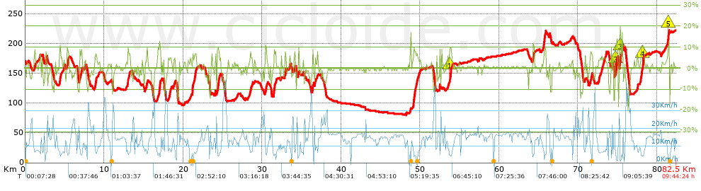
 Day or stage  One day stage  Distance  Climb in  IBP
 Day 1  19210 Camino de Santiago desde Ginebra (Vía Gebennensis) 01 Geneve - Seyssel  62 Km  1446 m  108
 Day 2  19211 Camino de Santiago desde Ginebra (Ví­a Gebennensis) 02 Seyssel - St Genix sur Guiers  64 Km  1502 m  133
 Day 3  19212 Camino de Santiago desde Ginebra (Vía Gebennensis) 03 St Genix sur Guiers - Faramans  65 Km  1387 m  108
 Day 4  19213 Camino de Santiago desde Ginebra (Vía Gebennensis) 04 Faramans - St Julien Molin Molette  70 Km  1526 m  116
 Day 5  19214 Camino de Santiago desde Ginebra (Vía Gebennensis) 05 St Julien Molin Molette - Tence  53 Km  1569 m  117
 Day 6  19215 Camino de Santiago desde Ginebra (Vía Gebennensis) 06 Tence - Le Puy en Velay  44 Km  992 m  71
 Day 7  19217 Camino de Santiago desde Ginebra (Chemin du Puy) 07 Le Puy en Velay - Le Sauvage  63 Km  2012 m  143
 Day 8  19218 Camino de Santiago desde Ginebra (Chemin du Puy) 08 Le Sauvage - Nasbinals  55 Km  1073 m  75
 Day 9  19219 Camino de Santiago desde Ginebra (Chemin du Puy) 09 Nasbinals - Espailon  41 Km  921 m  83
 Day 10  19220 Camino de Santiago desde Ginebra (Chemin du Puy) 10 Espailon - Conques  48 Km  1373 m  119
 Day 11  19221 Camino de Santiago desde Ginebra (Chemin du Puy) 11 Conques - Figeac  50 Km  1410 m  109
 Day 12  19222 Camino de Santiago desde Ginebra (Chemin du Puy) 12 Figeac - Limogne en Quercy  50 Km  1147 m  85
 Day 13  19223 Camino de Santiago desde Ginebra (Chemin du Puy) 13 Limogne en Quercy - Cahors  42 Km  629 m  40
 Day 14  19224 Camino de Santiago desde Ginebra (Chemin du Puy) 14 Cahors - Moissac  79 Km  1686 m  138
 Day 15  19225 Camino de Santiago desde Ginebra (Chemin du Puy) 15 Moissac - Lectoure  53 Km  833 m  61
 Day 16  19226 Camino de Santiago desde Ginebra (Chemin du Puy) 16 Lectoure - Eauze  69 Km  1165 m  81
 Day 17  19227 Camino de Santiago desde Ginebra (Chemin du Puy) 17 Eauze - Arzacq Arraziguet (This)  83 Km  1176 m  92
 Day 18  19228 Camino de Santiago desde Ginebra (Chemin du Puy) 18 Arzacq Arraziguet - Navarrenx  62 Km  1064 m  88
 Day 19  19229 Camino de Santiago desde Ginebra (Chemin du Puy) 19 Navarrenx - St Jean Pied de Port  66 Km  1489 m  109
 Day 20  19230 Camino de Santiago desde Ginebra (Camino Francés) 20 St Jean Pied de Port - Pamplona  66 Km  2211 m  176
 Day 21  19231 Camino de Santiago desde Ginebra (Camino Francés) 21 Pamplona - Estella  50 Km  1055 m  83
 Day 22  19232 Camino de Santiago desde Ginebra (Camino Francés) 22 Estella - Logroño  49 Km  932 m  68
 Day 23  19233 Camino de Santiago desde Ginebra (Camino Francés) 23 Logroño - Santo Domingo de la Calzada  50 Km  828 m  50
 Day 24  19234 Camino de Santiago desde Ginebra (Camino Francés) 24 Santo Domingo de la Calzada - Burgos  72 Km  1004 m  71
 Day 25  19235 Camino de Santiago desde Ginebra (Camino Francés) 25 Burgos - Carrión de los Condes  85 Km  695 m  60
 Day 26  19236 Camino de Santiago desde Ginebra (Camino Francés) 26 Carrión de los Condes - León  97 Km  624 m  64
 Day 27  19237 Camino de Santiago desde Ginebra (Camino Francés) 27 León - Rabanal del Camino  73 Km  807 m  59
 Day 28  19238 Camino de Santiago desde Ginebra (Camino Francés) 28 Rabanal del Camino - Villafranca del Bierzo  56 Km  872 m  57
 Day 29  19239 Camino de Santiago desde Ginebra (Camino Francés) 29 Villafranca del Bierzo - Sarria  68 Km  1575 m  128
 Day 30  19240 Camino de Santiago desde Ginebra (Camino Francés) 30 Sarria - Melide  61 Km  1332 m  86
 Day 31  19241 Camino de Santiago desde Ginebra (Camino Francés) 31 Melide - Santiago de Compostela  56 Km  1105 m  78
 Total 31 days  1902 Km  37440 m  92 / día

 Height in m      Climb in %      Speed in Km/h      Speed < 2 Km/h


Description of the route


Presence of ramps


 Climbs  Distance  % of the total  Speed  Your speed would be  Time  Your time would be
   15 - 30%  0.257  0.31  4.9  ?  0:03:09  ?
   10 - 15%  1.808  2.19  5.27  ?  0:20:36  ?
   5 - 10%  6.503  7.88  6.77  ?  0:57:39  ?
   1 - 5%  16.811  20.38  10.12  ?  1:39:41  ?
   Total*  25.38 Km  30.76 %  8.41 Km/h  ? Km/h    3:01:05 h  ? h  
 Flat
   1 - -1%  34.055 Km  41.28 %  14.39 Km/h  ? Km/h    2:22:01 h  ? h  
 Descents
   -1 - -5%  14.995  18.18  16.34  ?  0:55:03  ?
   -5 - -10%  5.47  6.63  20.24  ?  0:16:13  ?
   -10 - -15%  2.064  2.5  16.37  ?  0:07:34  ?
   -15 - -30%  0.541  0.66  16.09  ?  0:02:01  ?
   Total*  23.07 Km  27.96 %  17.12 Km/h  ? Km/h    1:20:51 h  ? h  
* The total has not necessarily coincide with the sum of the partials after correction of errors

How long would it take you?

How long would it take you to cover this route?
There are routes without a valid time information, but with your average stats you can assess the possible duration

zinaztli to cover this route you've need a time of:   6:43:57 h 
If you sign in and have a minimum of two tracks of this same modality, you can know your time for this route, calculated from your stats..


¿Cuanto consumirá tu E-BIKE?

Entra tu E-IBP (formato n,nn)

E-IBP :   X 90 = 


 Detected activity type =  ()
 Penalization due to track conditions: 50 %   ( > 50 % = MTB, < 50 % = RDB)
 Reliability of the track: B   (1176/61/0/-/-/61)
 Correction level applied to the track: 0
DIFFICULTY OF THE ROUTE
IBP = 90 BYC
According to your statistics
 Your time in motion would be: ? h
Your average speed would be: ? Km/h
 

 Total Distance: 82.5 Km
 Analysed distance: 82.5 Km
 Linear distance: 54.89 Km

 Cumulated positive ramps: 1175.73 m  list of points info
 Cumulated negative ramps: 1129.59 m
 Maximum height: 226.05 m
 Minimum height: 80.41 m
 Climbing Ratio: 4.63 %
 Descent ratio: 4.9 %
 Cumulated postive ramps per Km: 14.25 m
 Cumulated negative ramps per Km: 13.69 m

 Total time: 9:44:24 h
 Time in movement: 6:43:57 h
 According to your statistics
 Your time in motion would be: ? h  
 Stopped time: 3:00:27 h
 Maximum slope filter: ~30 %
 Minimum separation analysed: ~30 m
 Number of points: 2583   (cad. 31.94 m)
 Significant waypoints: 1504   (cad. 54.89 m / 58.23 %)

 Changes in direction per Km: 7.81
 Changes in direction > 5º por Km: 4.7
 Cumulated straight stretches: 26.604 Km
 Straight stretches per Km: 322.47 m
 Penalized slope changes: 8
 Penalized slope changes per Km: 0.097

 Average speed in total: 8.47 Km/h
 Average speed while moving: 12.25 Km/h
 According to your statistics
 Your average speed would be: ? Km/h  
 Maximum sustained speed: 53.05 Km/h


Comments

You can be the first one in commenting this route

 
My comments
:
Add comment  (Registered users)
 
Notify me answers to my comment  Do not notify answers to my comment


Share this route with a friend

Your friend will receive a message with a link to this page:
will see your email and your user name if you do it as registered user.


Write here your name (optional)

E-mail address of your friend(s). You can include various addresses separated by commas

Text or comment (optional) maximum 255 characters long, 255 Available characters

As a non registered users you need to fill-in the captcha text.
  Change image
Type the image characters.
 
 Share with a friend


Visited history

Delete history

Marked routes for review later or compare

My favorites


  Notify anomaly in this route Share in Facebook