Roses a Cadaqués

MTB
MTB
Ref..: 1145444
Published: 09/04/2024
Performed: 09/04/2024
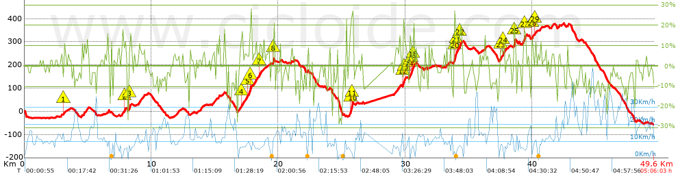
Distance in Km: 49.56
Climb in m: 1540
IBP: 141 BYC

Near ...
Canyelles Almadraba (Ajuntament Roses), Mas Fumats, El, Mas Oliva, El, Roses
jarcass
Author: jarcass
1341 published routes

Add to my Group or Club

 Height in m      Climb in %      Speed in Km/h      Speed < 2 Km/h

Climbs > 5%

Climbs >5% Climbs >10% Climbs >15% Climbs >20% Climbs >25%
 Steep slope of 173 m.   Average slope  Distances  Download as waypoint
1
 Km 2.795  6%  173 m
 Steep slope of 139 m.  Average slope  Distances  Download as waypoint
2
 Km 3.113  11%  107 m
3
 Km 3.22  6%  32 m
 Steep slope of 565 m.  Average slope  Distances  Download as waypoint
4
 Km 4.47  7%  565 m
 Steep slope of 104 m.  Average slope  Distances  Download as waypoint
5
 Km 6.532  14%  104 m
 Steep slope of 333 m.  Average slope  Distances  Download as waypoint
6
 Km 7.634  8%  234 m
7
 Km 7.869  14%  99 m
 Steep slope of 34 m.  Average slope  Distances  Download as waypoint
8
 Km 8.276  18%  34 m
 Steep slope of 530 m.  Average slope  Distances  Download as waypoint
9
 Km 8.963  8%  530 m
 Steep slope of 415 m.  Average slope  Distances  Download as waypoint
10
 Km 11.75  6%  415 m
 Steep slope of 102 m.  Average slope  Distances  Download as waypoint
11
 Km 13.58  6%  102 m
 Steep slope of 110 m.  Average slope  Distances  Download as waypoint
12
 Km 13.859  9%  110 m
 Steep slope of 326 m.  Average slope  Distances  Download as waypoint
13
 Km 14.782  7%  326 m
 Steep slope of 130 m.  Average slope  Distances  Download as waypoint
14
 Km 15.215  6%  130 m
 Steep slope of 237 m.  Average slope  Distances  Download as waypoint
15
 Km 16.753  7%  237 m
 Steep slope of 1269 m.  Average slope  Distances  Download as waypoint
16
 Km 17.021  7%  67 m
17
 Km 17.088  12%  68 m
18
 Km 17.157  9%  203 m
19
 Km 17.36  8%  100 m
20
 Km 17.46  9%  142 m
21
 Km 17.602  11%  147 m
22
 Km 17.749  15%  101 m
23
 Km 17.85  9%  137 m
24
 Km 17.986  6%  98 m
25
 Km 18.084  8%  101 m
26
 Km 18.185  12%  105 m
 Steep slope of 200 m.  Average slope  Distances  Download as waypoint
27
 Km 18.392  9%  98 m
28
 Km 18.49  8%  102 m
 Steep slope of 106 m.  Average slope  Distances  Download as waypoint
29
 Km 18.695  8%  106 m
 Steep slope of 101 m.  Average slope  Distances  Download as waypoint
30
 Km 18.896  5%  101 m
 Steep slope of 118 m.  Average slope  Distances  Download as waypoint
31
 Km 19.57  17%  118 m
 Steep slope of 142 m.  Average slope  Distances  Download as waypoint
32
 Km 20.093  8%  142 m
 Steep slope of 118 m.  Average slope  Distances  Download as waypoint
33
 Km 21.218  5%  118 m
 Steep slope of 100 m.  Average slope  Distances  Download as waypoint
34
 Km 25.315  7%  100 m
 Steep slope of 322 m.  Average slope  Distances  Download as waypoint
35
 Km 25.549  8%  97 m
36
 Km 25.646  16%  67 m
37
 Km 25.714  23%  64 m
38
 Km 25.778  28%  94 m
 Steep slope of 301 m.  Average slope  Distances  Download as waypoint
39
 Km 29.103  7%  301 m
 Steep slope of 100 m.  Average slope  Distances  Download as waypoint
40
 Km 29.504  12%  100 m
 Steep slope of 197 m.  Average slope  Distances  Download as waypoint
41
 Km 29.776  17%  130 m
42
 Km 29.906  14%  67 m
 Steep slope of 578 m.  Average slope  Distances  Download as waypoint
43
 Km 30.251  11%  103 m
44
 Km 30.354  11%  99 m
45
 Km 30.452  18%  100 m
46
 Km 30.552  16%  32 m
47
 Km 30.585  12%  68 m
48
 Km 30.653  8%  176 m
 Steep slope of 139 m.  Average slope  Distances  Download as waypoint
49
 Km 31.468  6%  139 m
 Steep slope of 134 m.  Average slope  Distances  Download as waypoint
50
 Km 33.173  7%  134 m
 Steep slope of 699 m.  Average slope  Distances  Download as waypoint
51
 Km 33.817  25%  97 m
52
 Km 33.914  15%  34 m
53
 Km 33.948  13%  195 m
54
 Km 34.144  9%  98 m
55
 Km 34.242  11%  103 m
56
 Km 34.345  12%  172 m
 Steep slope of 109 m.  Average slope  Distances  Download as waypoint
57
 Km 36.235  13%  109 m
 Steep slope of 435 m.  Average slope  Distances  Download as waypoint
58
 Km 37.354  5%  100 m
59
 Km 37.455  11%  95 m
60
 Km 37.549  9%  101 m
61
 Km 37.65  15%  139 m
 Steep slope of 137 m.  Average slope  Distances  Download as waypoint
62
 Km 38.062  6%  137 m
 Steep slope of 196 m.  Average slope  Distances  Download as waypoint
63
 Km 38.485  6%  32 m
64
 Km 38.518  24%  132 m
65
 Km 38.649  9%  32 m
 Steep slope of 365 m.  Average slope  Distances  Download as waypoint
66
 Km 39.172  7%  67 m
67
 Km 39.239  10%  101 m
68
 Km 39.34  17%  66 m
69
 Km 39.406  16%  64 m
70
 Km 39.47  10%  67 m
 Steep slope of 173 m.  Average slope  Distances  Download as waypoint
71
 Km 39.924  12%  138 m
72
 Km 40.062  14%  35 m
 Steep slope of 138 m.  Average slope  Distances  Download as waypoint
73
 Km 40.198  12%  104 m
74
 Km 40.303  6%  34 m
 Steep slope of 145 m.  Average slope  Distances  Download as waypoint
75
 Km 40.604  9%  145 m
 Steep slope of 207 m.  Average slope  Distances  Download as waypoint
76
 Km 41.458  8%  207 m
 Steep slope of 171 m.  Average slope  Distances  Download as waypoint
77
 Km 41.996  7%  171 m
 Steep slope of 140 m.  Average slope  Distances  Download as waypoint
78
 Km 42.709  9%  140 m


Description of the route


Presence of ramps


 Climbs  Distance  % of the total  Speed  Your speed would be  Time  Your time would be
   15 - 30%  2.225  4.49  6.53  ?  0:20:27  ?
   10 - 15%  3.113  6.28  8.93  ?  0:20:55  ?
   5 - 10%  7.729  15.59  10.16  ?  0:45:38  ?
   1 - 5%  7.738  15.61  7.59  ?  1:01:10  ?
   Total*  20.805 Km  41.98 %  8.43 Km/h  ? Km/h    2:28:10 h  ? h  
 Flat
   1 - -1%  8.535 Km  17.22 %  11.97 Km/h  ? Km/h    0:42:47 h  ? h  
 Descents
   -1 - -5%  6.166  12.44  16.75  ?  0:22:05  ?
   -5 - -10%  8.812  17.78  18.42  ?  0:28:42  ?
   -10 - -15%  3.514  7.09  18  ?  0:11:43  ?
   -15 - -30%  1.73  3.49  9.26  ?  0:11:13  ?
   Total*  20.223 Km  40.8 %  16.46 Km/h  ? Km/h    1:13:43 h  ? h  
* The total has not necessarily coincide with the sum of the partials after correction of errors

How long would it take you?

How long would it take you to cover this route?
There are routes without a valid time information, but with your average stats you can assess the possible duration

jarcass to cover this route you've need a time of:   4:24:40 h 
If you sign in and have a minimum of two tracks of this same modality, you can know your time for this route, calculated from your stats..


¿Cuanto consumirá tu E-BIKE?

Entra tu E-IBP (formato n,nn)

E-IBP :   X 141 = 


 Detected activity type =  ()
 Penalization due to track conditions: 86 %   ( > 50 % = MTB, < 50 % = RDB)
 Reliability of the track: C   (1543/53/0/-/-/53)
 Correction level applied to the track: 0
DIFFICULTY OF THE ROUTE
IBP = 141 BYC
According to your statistics
 Your time in motion would be: ? h
Your average speed would be: ? Km/h
 

 Total Distance: 49.56 Km
 Analysed distance: 49.56 Km
 Linear distance: 0.03 Km

 Cumulated positive ramps: 1540.13 m  list of points info
 Cumulated negative ramps: 1573.93 m
 Maximum height: 379 m
 Minimum height: -57 m
 Climbing Ratio: 7.4 %
 Descent ratio: 7.78 %
 Cumulated postive ramps per Km: 31.08 m
 Cumulated negative ramps per Km: 31.76 m

 Total time: 5:06:03 h
 Time in movement: 4:24:40 h
 According to your statistics
 Your time in motion would be: ? h  
 Stopped time: 0:41:23 h
 Maximum slope filter: ~30 %
 Minimum separation analysed: ~30 m
 Number of points: 3924   (cad. 12.63 m)
 Significant waypoints: 1357   (cad. 36.52 m / 34.58 %)

 Changes in direction per Km: 10.82
 Changes in direction > 5º por Km: 8.39
 Cumulated straight stretches: 6.296 Km
 Straight stretches per Km: 127.04 m
 Penalized slope changes: 15
 Penalized slope changes per Km: 0.303

 Average speed in total: 9.72 Km/h
 Average speed while moving: 11.24 Km/h
 According to your statistics
 Your average speed would be: ? Km/h  
 Maximum sustained speed: 54.51 Km/h


Comments

You can be the first one in commenting this route

 
My comments
:
Add comment  (Registered users)
 
Notify me answers to my comment  Do not notify answers to my comment


Share this route with a friend

Your friend will receive a message with a link to this page:
will see your email and your user name if you do it as registered user.


Write here your name (optional)

E-mail address of your friend(s). You can include various addresses separated by commas

Text or comment (optional) maximum 255 characters long, 255 Available characters

As a non registered users you need to fill-in the captcha text.
  Change image
Type the image characters.
 
 Share with a friend


Visited history

Delete history

Marked routes for review later or compare

My favorites


  Notify anomaly in this route Share in Facebook