Salvando la mañana por la muela

Road
Road
Ref..: 1145093
Published: 07/04/2024
Performed: 07/04/2024
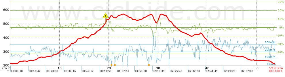
Distance in Km: 53.78
Climb in m: 512
IBP: 34 BYC

Near ...
Camino Real, Joyosa, La, Pinseque, Villarrapa
Sergio T
Author: Sergio T
105 published routes

Add to my Group or Club

 Height in m      Climb in %      Speed in Km/h      Speed < 2 Km/h


Description of the route


Presence of ramps


 Climbs  Distance  % of the total  Speed  Your speed would be  Time  Your time would be
   15 - 30%  0.003  0.01  11.84  ?  0:00:01  ?
   10 - 15%  0.202  0.38  9.1  ?  0:01:20  ?
   5 - 10%  1.264  2.35  10.76  ?  0:07:03  ?
   1 - 5%  15.614  29.03  16.12  ?  0:58:07  ?
   Total*  17.083 Km  31.77 %  15.41 Km/h  ? Km/h    1:06:31 h  ? h  
 Flat
   1 - -1%  18.378 Km  34.18 %  22.32 Km/h  ? Km/h    0:49:24 h  ? h  
 Descents
   -1 - -5%  16.262  30.24  26.55  ?  0:36:45  ?
   -5 - -10%  1.867  3.47  29.74  ?  0:03:46  ?
   -10 - -15%  0.219  0.41  31.49  ?  0:00:25  ?
   -15 - -30%  0  0  0  ?  0:00:00  ?
   Total*  18.348 Km  34.12 %  26.89 Km/h  ? Km/h    0:40:56 h  ? h  
* The total has not necessarily coincide with the sum of the partials after correction of errors

How long would it take you?

How long would it take you to cover this route?
There are routes without a valid time information, but with your average stats you can assess the possible duration

Sergio T to cover this route you've need a time of:   2:36:51 h 
If you sign in and have a minimum of two tracks of this same modality, you can know your time for this route, calculated from your stats..


How much will your E-BIKE consume?

Entra tu E-IBP (formato n,nn)

E-IBP :   X 34 = 


 Detected activity type =  ()
 Penalization due to track conditions: 42 %   ( > 50 % = MTB, < 50 % = RDB)
 Reliability of the track: D   (617/41/1/3/-/63)
 Correction level applied to the track: 4        See analyis without corrections
DIFFICULTY OF THE ROUTE
IBP = 34 BYC
According to your statistics
 Your time in motion would be: ? h
Your average speed would be: ? Km/h
 

 Total Distance: 53.78 Km
 Analysed distance: 53.78 Km
 Linear distance: 0.01 Km

 Cumulated positive ramps: 512.15 m  list of points info
 Cumulated negative ramps: 510.93 m
 Maximum height: 568.76 m
 Minimum height: 213.17 m
 Climbing Ratio: 3 %
 Descent ratio: 2.78 %
 Cumulated postive ramps per Km: 9.52 m
 Cumulated negative ramps per Km: 9.5 m

 Total time: 3:12:09 h
 Time in movement: 2:36:51 h
 According to your statistics
 Your time in motion would be: ? h  
 Stopped time: 0:35:18 h
 Maximum slope filter: ~30 %
 Minimum separation analysed: ~30 m
 Number of points: 4036   (cad. 13.32 m)
 Significant waypoints: 1482   (cad. 36.31 m / 36.72 %)

 Changes in direction per Km: 10.82
 Changes in direction > 5º por Km: 5.8
 Cumulated straight stretches: 17.425 Km
 Straight stretches per Km: 324.01 m
 Penalized slope changes: 5
 Penalized slope changes per Km: 0.093

 Average speed in total: 16.79 Km/h
 Average speed while moving: 20.57 Km/h
 According to your statistics
 Your average speed would be: ? Km/h  
 Maximum sustained speed: 44.86 Km/h


Comments

You can be the first one in commenting this route

 
My comments
:
Add comment  (Registered users)
 
Notify me answers to my comment  Do not notify answers to my comment


Visited history

Delete history

Marked routes for review later or compare

My favorites


  Notify anomaly in this route Share in Facebook