Téli Mátra M Hike

MTB
MTB
Ref..: 1136494
Published: 28/01/2024
Performed: 27/01/2024
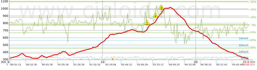
Distance in Km: 25.61
Climb in m: 923
IBP: 82 BYC

Attila Sábián
587 published routes

Add to my Group or Club

 Height in m      Climb in %      Speed in Km/h      Speed < 2 Km/h

Climbs > 5%

Climbs >5% Climbs >10% Climbs >15% Climbs >20% Climbs >25%
 Steep slope of 340 m.   Average slope  Distances  Download as waypoint
1
 Km 0.98  8%  340 m
 Steep slope of 380 m.  Average slope  Distances  Download as waypoint
2
 Km 3.099  11%  173 m
3
 Km 3.272  9%  207 m
 Steep slope of 154 m.  Average slope  Distances  Download as waypoint
4
 Km 3.992  9%  154 m
 Steep slope of 209 m.  Average slope  Distances  Download as waypoint
5
 Km 4.521  6%  209 m
 Steep slope of 150 m.  Average slope  Distances  Download as waypoint
6
 Km 5.194  10%  150 m
 Steep slope of 215 m.  Average slope  Distances  Download as waypoint
7
 Km 5.484  12%  178 m
8
 Km 5.661  6%  37 m
 Steep slope of 176 m.  Average slope  Distances  Download as waypoint
9
 Km 6.579  6%  176 m
 Steep slope of 163 m.  Average slope  Distances  Download as waypoint
10
 Km 6.934  8%  163 m
 Steep slope of 102 m.  Average slope  Distances  Download as waypoint
11
 Km 8.072  5%  102 m
 Steep slope of 179 m.  Average slope  Distances  Download as waypoint
12
 Km 8.784  8%  73 m
13
 Km 8.857  13%  106 m
 Steep slope of 1444 m.  Average slope  Distances  Download as waypoint
14
 Km 9.294  5%  100 m
15
 Km 9.394  12%  30 m
16
 Km 9.424  15%  135 m
17
 Km 9.559  12%  73 m
18
 Km 9.632  8%  493 m
19
 Km 10.124  13%  99 m
20
 Km 10.223  17%  104 m
21
 Km 10.327  12%  81 m
22
 Km 10.408  7%  144 m
23
 Km 10.552  13%  41 m
24
 Km 10.592  16%  144 m
 Steep slope of 35 m.  Average slope  Distances  Download as waypoint
25
 Km 10.776  13%  35 m
 Steep slope of 115 m.  Average slope  Distances  Download as waypoint
26
 Km 12.066  7%  115 m
 Steep slope of 104 m.  Average slope  Distances  Download as waypoint
27
 Km 12.571  11%  104 m
 Steep slope of 189 m.  Average slope  Distances  Download as waypoint
28
 Km 12.822  6%  189 m
 Steep slope of 2217 m.  Average slope  Distances  Download as waypoint
29
 Km 14.456  7%  63 m
30
 Km 14.519  12%  167 m
31
 Km 14.686  20%  32 m
32
 Km 14.718  21%  139 m
33
 Km 14.857  26%  34 m
34
 Km 14.892  9%  635 m
35
 Km 15.527  9%  104 m
36
 Km 15.631  16%  34 m
37
 Km 15.665  23%  243 m
38
 Km 15.908  26%  34 m
39
 Km 15.941  12%  96 m
40
 Km 16.037  19%  77 m
41
 Km 16.114  12%  150 m
42
 Km 16.264  22%  182 m
43
 Km 16.446  20%  74 m
44
 Km 16.52  14%  153 m
 Steep slope of 112 m.  Average slope  Distances  Download as waypoint
45
 Km 17.129  8%  112 m


Description of the route


Presence of ramps


 Climbs  Distance  % of the total  Speed  Your speed would be  Time  Your time would be
   15 - 30%  1.442  5.63  3.16  ?  0:27:24  ?
   10 - 15%  1.526  5.96  3.79  ?  0:24:09  ?
   5 - 10%  3.596  14.04  4.45  ?  0:48:27  ?
   1 - 5%  5.498  21.47  5.19  ?  1:03:37  ?
   Total*  12.062 Km  47.09 %  4.42 Km/h  ? Km/h    2:43:37 h  ? h  
 Flat
   1 - -1%  2.081 Km  8.13 %  4.43 Km/h  ? Km/h    0:28:12 h  ? h  
 Descents
   -1 - -5%  4.42  17.26  4.89  ?  0:54:14  ?
   -5 - -10%  3.483  13.6  4.77  ?  0:43:46  ?
   -10 - -15%  2.213  8.64  4.41  ?  0:30:05  ?
   -15 - -30%  1.354  5.29  3.22  ?  0:25:15  ?
   Total*  11.47 Km  44.78 %  4.49 Km/h  ? Km/h    2:33:20 h  ? h  
* The total has not necessarily coincide with the sum of the partials after correction of errors

How long would it take you?

How long would it take you to cover this route?
There are routes without a valid time information, but with your average stats you can assess the possible duration

Attila Sábián to cover this route you've need a time of:   5:45:09 h 
If you sign in and have a minimum of two tracks of this same modality, you can know your time for this route, calculated from your stats..


¿Cuanto consumirá tu E-BIKE?

Entra tu E-IBP (formato n,nn)

E-IBP :   X 82 = 


 Detected activity type =  ()
 Penalization due to track conditions: 56 %   ( > 50 % = MTB, < 50 % = RDB)
 Reliability of the track: A   (923/79/0/-/-/79)
 Correction level applied to the track: 0
DIFFICULTY OF THE ROUTE
IBP = 82 BYC
According to your statistics
 Your time in motion would be: ? h
Your average speed would be: ? Km/h
 

 Total Distance: 25.61 Km
 Analysed distance: 25.61 Km
 Linear distance: 0.08 Km

 Cumulated positive ramps: 923.25 m  list of points info
 Cumulated negative ramps: 924.65 m
 Maximum height: 1017.2 m
 Minimum height: 314.4 m
 Climbing Ratio: 7.65 %
 Descent ratio: 8.06 %
 Cumulated postive ramps per Km: 36.05 m
 Cumulated negative ramps per Km: 36.11 m

 Total time: 6:00:13 h
 Time in movement: 5:45:09 h
 According to your statistics
 Your time in motion would be: ? h  
 Stopped time: 0:15:04 h
 Maximum slope filter: ~30 %
 Minimum separation analysed: ~30 m
 Number of points: 1929   (cad. 13.28 m)
 Significant waypoints: 706   (cad. 36.28 m / 36.6 %)

 Changes in direction per Km: 13.55
 Changes in direction > 5º por Km: 10.66
 Cumulated straight stretches: 3.69 Km
 Straight stretches per Km: 144.08 m
 Penalized slope changes: 8
 Penalized slope changes per Km: 0.312

 Average speed in total: 4.27 Km/h
 Average speed while moving: 4.45 Km/h
 According to your statistics
 Your average speed would be: ? Km/h  
 Maximum sustained speed: 8.04 Km/h


Comments

You can be the first one in commenting this route

 
My comments
:
Add comment  (Registered users)
 
Notify me answers to my comment  Do not notify answers to my comment


Share this route with a friend

Your friend will receive a message with a link to this page:
will see your email and your user name if you do it as registered user.


Write here your name (optional)

E-mail address of your friend(s). You can include various addresses separated by commas

Text or comment (optional) maximum 255 characters long, 255 Available characters

As a non registered users you need to fill-in the captcha text.
  Change image
Type the image characters.
 
 Share with a friend


Visited history

Delete history

Marked routes for review later or compare

My favorites


  Notify anomaly in this route Share in Facebook