CICLI SUBIR A LA MONTAÑA

MTB
MTB
Ref..: 1133968
Published: 02/01/2024
Performed: 01/01/2024
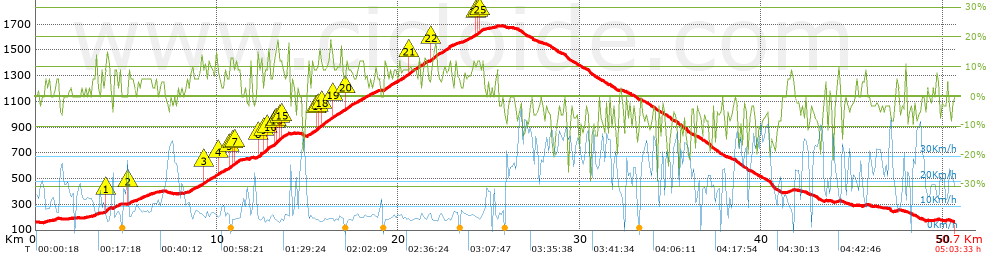
Distance in Km: 50.74
Climb in m: 1716
IBP: 123 BYC

Near ...
Batlloria, La (Sant Celoni), Sant Celoni, Santa Maria De Palautordera

 Height in m      Climb in %      Speed in Km/h      Speed < 2 Km/h

Climbs > 5%

Climbs >5% Climbs >10% Climbs >15% Climbs >20% Climbs >25%
 Steep slope of 174 m.   Average slope  Distances  Download as waypoint
1
 Km 0.511  5%  174 m
 Steep slope of 194 m.  Average slope  Distances  Download as waypoint
2
 Km 1.08  7%  194 m
 Steep slope of 202 m.  Average slope  Distances  Download as waypoint
3
 Km 3.127  5%  202 m
 Steep slope of 368 m.  Average slope  Distances  Download as waypoint
4
 Km 3.771  7%  102 m
5
 Km 3.874  13%  199 m
6
 Km 4.073  6%  67 m
 Steep slope of 300 m.  Average slope  Distances  Download as waypoint
7
 Km 4.294  8%  300 m
 Steep slope of 297 m.  Average slope  Distances  Download as waypoint
8
 Km 5.094  11%  97 m
9
 Km 5.191  7%  200 m
 Steep slope of 703 m.  Average slope  Distances  Download as waypoint
10
 Km 5.594  7%  703 m
 Steep slope of 166 m.  Average slope  Distances  Download as waypoint
11
 Km 6.462  5%  166 m
 Steep slope of 734 m.  Average slope  Distances  Download as waypoint
12
 Km 8.472  8%  734 m
 Steep slope of 1897 m.  Average slope  Distances  Download as waypoint
13
 Km 9.307  13%  101 m
14
 Km 9.407  8%  663 m
15
 Km 10.07  10%  101 m
16
 Km 10.171  8%  515 m
17
 Km 10.686  10%  161 m
18
 Km 10.847  10%  127 m
19
 Km 10.974  11%  98 m
20
 Km 11.071  11%  131 m
 Steep slope of 134 m.  Average slope  Distances  Download as waypoint
21
 Km 11.811  9%  134 m
 Steep slope of 1672 m.  Average slope  Distances  Download as waypoint
22
 Km 12.216  6%  34 m
23
 Km 12.25  13%  200 m
24
 Km 12.449  9%  129 m
25
 Km 12.579  15%  104 m
26
 Km 12.683  9%  96 m
27
 Km 12.78  14%  125 m
28
 Km 12.905  7%  233 m
29
 Km 13.138  11%  64 m
30
 Km 13.202  14%  97 m
31
 Km 13.3  15%  130 m
32
 Km 13.429  11%  98 m
33
 Km 13.527  13%  128 m
34
 Km 13.655  8%  234 m
 Steep slope of 1137 m.  Average slope  Distances  Download as waypoint
35
 Km 15.001  9%  99 m
36
 Km 15.101  9%  399 m
37
 Km 15.499  14%  95 m
38
 Km 15.594  12%  159 m
39
 Km 15.754  10%  385 m
 Steep slope of 1491 m.  Average slope  Distances  Download as waypoint
40
 Km 16.236  10%  97 m
41
 Km 16.333  12%  100 m
42
 Km 16.433  9%  665 m
43
 Km 17.097  12%  164 m
44
 Km 17.261  8%  465 m
 Steep slope of 1019 m.  Average slope  Distances  Download as waypoint
45
 Km 17.825  8%  1019 m
 Steep slope of 2294 m.  Average slope  Distances  Download as waypoint
46
 Km 19.218  9%  1348 m
47
 Km 20.567  12%  165 m
48
 Km 20.732  9%  781 m
 Steep slope of 1573 m.  Average slope  Distances  Download as waypoint
49
 Km 21.612  6%  176 m
50
 Km 21.788  12%  266 m
51
 Km 22.054  9%  1131 m
 Steep slope of 537 m.  Average slope  Distances  Download as waypoint
52
 Km 23.496  7%  537 m
 Steep slope of 558 m.  Average slope  Distances  Download as waypoint
53
 Km 24.137  10%  131 m
54
 Km 24.267  10%  129 m
55
 Km 24.396  11%  97 m
56
 Km 24.493  11%  99 m
57
 Km 24.592  9%  102 m
 Steep slope of 132 m.  Average slope  Distances  Download as waypoint
58
 Km 25.327  8%  132 m
 Steep slope of 130 m.  Average slope  Distances  Download as waypoint
59
 Km 41.398  5%  130 m
 Steep slope of 103 m.  Average slope  Distances  Download as waypoint
60
 Km 41.633  8%  103 m
 Steep slope of 110 m.  Average slope  Distances  Download as waypoint
61
 Km 45.592  5%  110 m
 Steep slope of 105 m.  Average slope  Distances  Download as waypoint
62
 Km 47.444  9%  105 m


Description of the route


Presence of ramps


 Climbs  Distance  % of the total  Speed  Your speed would be  Time  Your time would be
   15 - 30%  0.917  1.81  5.89  ?  0:09:21  ?
   10 - 15%  3.953  7.79  6.76  ?  0:35:05  ?
   5 - 10%  12.577  24.79  8.03  ?  1:33:57  ?
   1 - 5%  4.902  9.66  12.4  ?  0:23:43  ?
   Total*  22.349 Km  44.05 %  8.27 Km/h  ? Km/h    2:42:06 h  ? h  
 Flat
   1 - -1%  7.535 Km  14.85 %  18.63 Km/h  ? Km/h    0:24:16 h  ? h  
 Descents
   -1 - -5%  6.734  13.27  22.83  ?  0:17:42  ?
   -5 - -10%  7.929  15.63  23.49  ?  0:20:15  ?
   -10 - -15%  3.516  6.93  22.09  ?  0:09:33  ?
   -15 - -30%  2.673  5.27  21.15  ?  0:07:35  ?
   Total*  20.852 Km  41.1 %  22.71 Km/h  ? Km/h    0:55:05 h  ? h  
* The total has not necessarily coincide with the sum of the partials after correction of errors

How long would it take you?

How long would it take you to cover this route?
There are routes without a valid time information, but with your average stats you can assess the possible duration

Kiko_Vitamina__B_&_G to cover this route you've need a time of:   4:01:27 h 
If you sign in and have a minimum of two tracks of this same modality, you can know your time for this route, calculated from your stats..


¿Cuanto consumirá tu E-BIKE?

Entra tu E-IBP (formato n,nn)

E-IBP :   X 123 = 


 Detected activity type =  ()
 Penalization due to track conditions: 63 %   ( > 50 % = MTB, < 50 % = RDB)
 Reliability of the track: A   (1716/87/0/-/-/87)
 Correction level applied to the track: 0
DIFFICULTY OF THE ROUTE
IBP = 123 BYC
According to your statistics
 Your time in motion would be: ? h
Your average speed would be: ? Km/h
 

 Total Distance: 50.74 Km
 Analysed distance: 50.74 Km
 Linear distance: 0.19 Km

 Cumulated positive ramps: 1715.7 m  list of points info
 Cumulated negative ramps: 1712.7 m
 Maximum height: 1688.5 m
 Minimum height: 159.4 m
 Climbing Ratio: 7.68 %
 Descent ratio: 8.21 %
 Cumulated postive ramps per Km: 33.81 m
 Cumulated negative ramps per Km: 33.75 m

 Total time: 5:03:33 h
 Time in movement: 4:01:27 h
 According to your statistics
 Your time in motion would be: ? h  
 Stopped time: 1:02:06 h
 Maximum slope filter: ~30 %
 Minimum separation analysed: ~30 m
 Number of points: 4094   (cad. 12.39 m)
 Significant waypoints: 1462   (cad. 34.7 m / 35.71 %)

 Changes in direction per Km: 10.15
 Changes in direction > 5º por Km: 6.86
 Cumulated straight stretches: 9.651 Km
 Straight stretches per Km: 190.2 m
 Penalized slope changes: 7
 Penalized slope changes per Km: 0.138

 Average speed in total: 10.03 Km/h
 Average speed while moving: 12.61 Km/h
 According to your statistics
 Your average speed would be: ? Km/h  
 Maximum sustained speed: 50.54 Km/h


Comments

You can be the first one in commenting this route

 
My comments
:
Add comment  (Registered users)
 
Notify me answers to my comment  Do not notify answers to my comment


Share this route with a friend

Your friend will receive a message with a link to this page:
will see your email and your user name if you do it as registered user.


Write here your name (optional)

E-mail address of your friend(s). You can include various addresses separated by commas

Text or comment (optional) maximum 255 characters long, 255 Available characters

As a non registered users you need to fill-in the captcha text.
  Change image
Type the image characters.
 
 Share with a friend


Visited history

Delete history

Marked routes for review later or compare

My favorites


  Notify anomaly in this route Share in Facebook