CICLI PALESTRINS-ST ELIAS--ST CELONI

MTB
MTB
Ref..: 1129963
Published: 25/11/2023
Performed: 25/11/2023
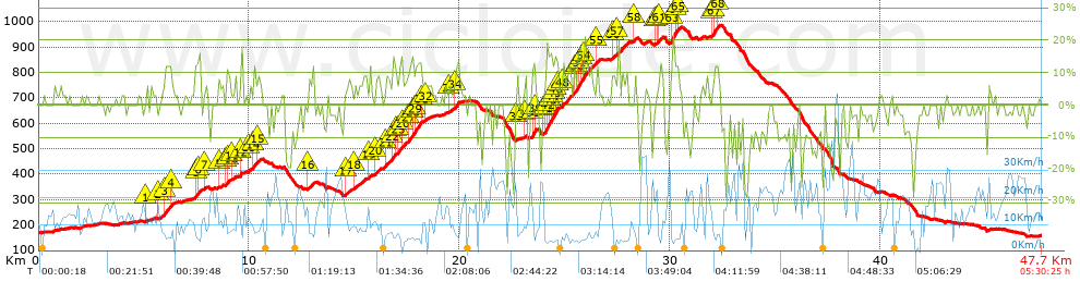
Distance in Km: 47.73
Climb in m: 1389
IBP: 115 BYC

Near ...
Batlloria, La (Sant Celoni), Sant Celoni, Santa Maria De Palautordera

 Height in m      Climb in %      Speed in Km/h      Speed < 2 Km/h

Climbs > 5%

Climbs >5% Climbs >10% Climbs >15% Climbs >20% Climbs >25%
 Steep slope of 102 m.   Average slope  Distances  Download as waypoint
1
 Km 5.056  5%  102 m
 Steep slope of 605 m.  Average slope  Distances  Download as waypoint
2
 Km 5.692  6%  271 m
3
 Km 5.964  11%  300 m
4
 Km 6.264  11%  34 m
 Steep slope of 254 m.  Average slope  Distances  Download as waypoint
5
 Km 7.434  11%  98 m
6
 Km 7.532  13%  156 m
 Steep slope of 104 m.  Average slope  Distances  Download as waypoint
7
 Km 7.867  7%  104 m
 Steep slope of 181 m.  Average slope  Distances  Download as waypoint
8
 Km 8.545  5%  181 m
 Steep slope of 204 m.  Average slope  Distances  Download as waypoint
9
 Km 8.906  11%  105 m
10
 Km 9.011  6%  99 m
 Steep slope of 133 m.  Average slope  Distances  Download as waypoint
11
 Km 9.209  6%  133 m
 Steep slope of 101 m.  Average slope  Distances  Download as waypoint
12
 Km 9.552  14%  101 m
 Steep slope of 552 m.  Average slope  Distances  Download as waypoint
13
 Km 9.973  6%  243 m
14
 Km 10.216  13%  134 m
15
 Km 10.35  8%  175 m
 Steep slope of 339 m.  Average slope  Distances  Download as waypoint
16
 Km 12.784  8%  339 m
 Steep slope of 314 m.  Average slope  Distances  Download as waypoint
17
 Km 14.568  7%  314 m
 Steep slope of 408 m.  Average slope  Distances  Download as waypoint
18
 Km 14.995  6%  408 m
 Steep slope of 139 m.  Average slope  Distances  Download as waypoint
19
 Km 15.677  9%  139 m
 Steep slope of 414 m.  Average slope  Distances  Download as waypoint
20
 Km 15.957  6%  414 m
 Steep slope of 1619 m.  Average slope  Distances  Download as waypoint
21
 Km 16.472  8%  338 m
22
 Km 16.81  13%  134 m
23
 Km 16.944  6%  102 m
24
 Km 17.046  8%  66 m
25
 Km 17.112  11%  168 m
26
 Km 17.28  8%  319 m
27
 Km 17.599  11%  166 m
28
 Km 17.765  12%  97 m
29
 Km 17.862  13%  229 m
 Steep slope of 167 m.  Average slope  Distances  Download as waypoint
30
 Km 18.125  8%  63 m
31
 Km 18.188  5%  104 m
 Steep slope of 103 m.  Average slope  Distances  Download as waypoint
32
 Km 18.398  7%  103 m
 Steep slope of 402 m.  Average slope  Distances  Download as waypoint
33
 Km 19.484  6%  303 m
34
 Km 19.787  11%  99 m
 Steep slope of 138 m.  Average slope  Distances  Download as waypoint
35
 Km 22.694  7%  138 m
 Steep slope of 105 m.  Average slope  Distances  Download as waypoint
36
 Km 23.106  8%  105 m
 Steep slope of 209 m.  Average slope  Distances  Download as waypoint
37
 Km 23.424  10%  42 m
38
 Km 23.466  17%  102 m
39
 Km 23.568  17%  65 m
 Steep slope of 746 m.  Average slope  Distances  Download as waypoint
40
 Km 23.988  6%  68 m
41
 Km 24.056  14%  98 m
42
 Km 24.155  15%  95 m
43
 Km 24.249  15%  129 m
44
 Km 24.378  14%  96 m
45
 Km 24.474  17%  133 m
46
 Km 24.607  15%  32 m
47
 Km 24.639  10%  95 m
 Steep slope of 1479 m.  Average slope  Distances  Download as waypoint
48
 Km 24.875  9%  558 m
49
 Km 25.433  11%  165 m
50
 Km 25.598  15%  95 m
51
 Km 25.693  16%  67 m
52
 Km 25.76  10%  31 m
53
 Km 25.791  16%  96 m
54
 Km 25.887  10%  467 m
 Steep slope of 130 m.  Average slope  Distances  Download as waypoint
55
 Km 26.454  8%  130 m
 Steep slope of 171 m.  Average slope  Distances  Download as waypoint
56
 Km 27.235  8%  171 m
 Steep slope of 454 m.  Average slope  Distances  Download as waypoint
57
 Km 27.504  9%  454 m
 Steep slope of 129 m.  Average slope  Distances  Download as waypoint
58
 Km 28.253  8%  129 m
 Steep slope of 437 m.  Average slope  Distances  Download as waypoint
59
 Km 29.271  5%  134 m
60
 Km 29.405  7%  101 m
61
 Km 29.506  8%  202 m
 Steep slope of 461 m.  Average slope  Distances  Download as waypoint
62
 Km 30.032  9%  33 m
63
 Km 30.065  19%  162 m
64
 Km 30.227  12%  133 m
65
 Km 30.36  7%  133 m
 Steep slope of 442 m.  Average slope  Distances  Download as waypoint
66
 Km 31.956  7%  106 m
67
 Km 32.062  14%  233 m
68
 Km 32.295  7%  103 m


Description of the route


Presence of ramps


 Climbs  Distance  % of the total  Speed  Your speed would be  Time  Your time would be
   15 - 30%  1.462  3.06  5.35  ?  0:16:24  ?
   10 - 15%  2.951  6.18  6.58  ?  0:26:54  ?
   5 - 10%  7.671  16.07  8.86  ?  0:51:57  ?
   1 - 5%  7.065  14.8  11.62  ?  0:36:29  ?
   Total*  19.149 Km  40.12 %  8.72 Km/h  ? Km/h    2:11:44 h  ? h  
 Flat
   1 - -1%  11.188 Km  23.44 %  16.31 Km/h  ? Km/h    0:41:10 h  ? h  
 Descents
   -1 - -5%  6.859  14.37  17.61  ?  0:23:22  ?
   -5 - -10%  5.416  11.35  18.05  ?  0:18:00  ?
   -10 - -15%  2.712  5.68  21.36  ?  0:07:37  ?
   -15 - -30%  2.411  5.05  15.28  ?  0:09:28  ?
   Total*  17.397 Km  36.45 %  17.86 Km/h  ? Km/h    0:58:27 h  ? h  
* The total has not necessarily coincide with the sum of the partials after correction of errors

How long would it take you?

How long would it take you to cover this route?
There are routes without a valid time information, but with your average stats you can assess the possible duration

Kiko_Vitamina__B_&_G to cover this route you've need a time of:   3:51:21 h 
If you sign in and have a minimum of two tracks of this same modality, you can know your time for this route, calculated from your stats..


¿Cuanto consumirá tu E-BIKE?

Entra tu E-IBP (formato n,nn)

E-IBP :   X 115 = 


 Detected activity type =  ()
 Penalization due to track conditions: 69 %   ( > 50 % = MTB, < 50 % = RDB)
 Reliability of the track: A   (1389/76/0/-/-/76)
 Correction level applied to the track: 0
DIFFICULTY OF THE ROUTE
IBP = 115 BYC
According to your statistics
 Your time in motion would be: ? h
Your average speed would be: ? Km/h
 

 Total Distance: 47.73 Km
 Analysed distance: 47.73 Km
 Linear distance: 0.17 Km

 Cumulated positive ramps: 1388.7 m  list of points info
 Cumulated negative ramps: 1398.6 m
 Maximum height: 986.7 m
 Minimum height: 155.8 m
 Climbing Ratio: 7.25 %
 Descent ratio: 8.04 %
 Cumulated postive ramps per Km: 29.09 m
 Cumulated negative ramps per Km: 29.3 m

 Total time: 5:30:25 h
 Time in movement: 3:51:21 h
 According to your statistics
 Your time in motion would be: ? h  
 Stopped time: 1:39:04 h
 Maximum slope filter: ~30 %
 Minimum separation analysed: ~30 m
 Number of points: 3916   (cad. 12.19 m)
 Significant waypoints: 1360   (cad. 35.1 m / 34.73 %)

 Changes in direction per Km: 11.57
 Changes in direction > 5º por Km: 8.55
 Cumulated straight stretches: 7.943 Km
 Straight stretches per Km: 166.42 m
 Penalized slope changes: 9
 Penalized slope changes per Km: 0.189

 Average speed in total: 8.67 Km/h
 Average speed while moving: 12.38 Km/h
 According to your statistics
 Your average speed would be: ? Km/h  
 Maximum sustained speed: 59.67 Km/h


Comments

You can be the first one in commenting this route

 
My comments
:
Add comment  (Registered users)
 
Notify me answers to my comment  Do not notify answers to my comment


Share this route with a friend

Your friend will receive a message with a link to this page:
will see your email and your user name if you do it as registered user.


Write here your name (optional)

E-mail address of your friend(s). You can include various addresses separated by commas

Text or comment (optional) maximum 255 characters long, 255 Available characters

As a non registered users you need to fill-in the captcha text.
  Change image
Type the image characters.
 
 Share with a friend


Visited history

Delete history

Marked routes for review later or compare

My favorites


  Notify anomaly in this route Share in Facebook