Sulens

Hiking
Hiking
Ref..: 1122193
Published: 24/09/2023
Performed: 23/09/2023
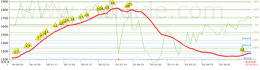
Distance in Km: 8.39
Climb in m: 698
IBP: 78 HKG

Autor 33750
Author: Autor 33750
206 published routes

Add to my Group or Club

 Height in m      Climb in %      Speed in Km/h      Speed < 2 Km/h

Climbs > 5%

Climbs >5% Climbs >10% Climbs >15% Climbs >20% Climbs >25%
 Steep slope of 1857 m.   Average slope  Distances  Download as waypoint
1
 Km 0.16  9%  70 m
2
 Km 0.23  11%  62 m
3
 Km 0.292  23%  229 m
4
 Km 0.521  12%  101 m
5
 Km 0.622  15%  65 m
6
 Km 0.686  29%  296 m
7
 Km 0.982  25%  95 m
8
 Km 1.077  21%  33 m
9
 Km 1.11  29%  62 m
10
 Km 1.172  27%  100 m
11
 Km 1.273  24%  264 m
12
 Km 1.537  16%  226 m
13
 Km 1.763  18%  93 m
14
 Km 1.856  21%  96 m
15
 Km 1.952  18%  65 m
 Steep slope of 925 m.  Average slope  Distances  Download as waypoint
16
 Km 2.176  10%  340 m
17
 Km 2.517  13%  199 m
18
 Km 2.715  18%  352 m
19
 Km 3.067  21%  34 m
 Steep slope of 384 m.  Average slope  Distances  Download as waypoint
20
 Km 3.193  9%  158 m
21
 Km 3.351  13%  32 m
22
 Km 3.383  17%  30 m
23
 Km 3.413  29%  133 m
24
 Km 3.546  16%  31 m
 Steep slope of 192 m.  Average slope  Distances  Download as waypoint
25
 Km 4.038  6%  32 m
26
 Km 4.07  23%  97 m
27
 Km 4.167  10%  63 m
 Steep slope of 130 m.  Average slope  Distances  Download as waypoint
28
 Km 8.063  11%  130 m


Description of the route


Presence of ramps


 Climbs  Distance  % of the total  Speed  Your speed would be  Time  Your time would be
   15 - 30%  1.987  23.7  3.29  ?  0:36:16  ?
   10 - 15%  0.513  6.12  3.79  ?  0:08:08  ?
   5 - 10%  1.061  12.65  3.79  ?  0:16:49  ?
   1 - 5%  0.414  4.94  4.41  ?  0:05:38  ?
   Total*  4.339 Km  51.73 %  3.47 Km/h  ? Km/h    1:14:56 h  ? h  
 Flat
   1 - -1%  0.413 Km  4.92 %  4.33 Km/h  ? Km/h    0:05:43 h  ? h  
 Descents
   -1 - -5%  0.488  5.82  4.59  ?  0:06:23  ?
   -5 - -10%  0.999  11.91  3.75  ?  0:16:00  ?
   -10 - -15%  0.547  6.52  4.62  ?  0:07:06  ?
   -15 - -30%  0.78  9.31  4.52  ?  0:10:21  ?
   Total*  3.635 Km  43.34 %  3.76 Km/h  ? Km/h    0:58:00 h  ? h  
* The total has not necessarily coincide with the sum of the partials after correction of errors

How long would it take you?

How long would it take you to cover this route?
There are routes without a valid time information, but with your average stats you can assess the possible duration

Autor 33750 to cover this route you've need a time of:   2:18:39 h 
If you sign in and have a minimum of two tracks of this same modality, you can know your time for this route, calculated from your stats..


 Detected activity type =  ()
 Penalization due to track conditions: 0 %   ( > 50 % = MTB, < 50 % = RDB)
 Reliability of the track: A   (698/86/0/-/-/86)
 Correction level applied to the track: 0
DIFFICULTY OF THE ROUTE
IBP = 78 HKG
According to your statistics
 Your time in motion would be: ? h
Your average speed would be: ? Km/h
 

 Total Distance: 8.39 Km
 Analysed distance: 8.39 Km
 Linear distance: 0.27 Km

 Cumulated positive ramps: 698 m  list of points info
 Cumulated negative ramps: 647.43 m
 Maximum height: 1832 m
 Minimum height: 1220 m
 Climbing Ratio: 16.09 %
 Descent ratio: 17.81 %
 Cumulated postive ramps per Km: 83.19 m
 Cumulated negative ramps per Km: 77.17 m

 Total time: 2:50:56 h
 Time in movement: 2:18:39 h
 According to your statistics
 Your time in motion would be: ? h  
 Stopped time: 0:32:17 h
 Maximum slope filter: ~55 %
 Minimum separation analysed: ~30 m
 Number of points: 778   (cad. 10.78 m)
 Significant waypoints: 258   (cad. 32.51 m / 33.16 %)

 Changes in direction per Km: 15.02
 Changes in direction > 5º por Km: 12.4
 Cumulated straight stretches: 0.953 Km
 Straight stretches per Km: 113.59 m
 Penalized slope changes: 5
 Penalized slope changes per Km: 0.596

 Average speed in total: 2.94 Km/h
 Average speed while moving: 3.63 Km/h
 According to your statistics
 Your average speed would be: ? Km/h  
 Maximum sustained speed: 7.04 Km/h


Comments

You can be the first one in commenting this route

 
My comments
:
Add comment  (Registered users)
 
Notify me answers to my comment  Do not notify answers to my comment


Share this route with a friend

Your friend will receive a message with a link to this page:
will see your email and your user name if you do it as registered user.


Write here your name (optional)

E-mail address of your friend(s). You can include various addresses separated by commas

Text or comment (optional) maximum 255 characters long, 255 Available characters

As a non registered users you need to fill-in the captcha text.
  Change image
Type the image characters.
 
 Share with a friend


Visited history

Delete history

Marked routes for review later or compare

My favorites


  Notify anomaly in this route Share in Facebook