Monte= sangre y sudor Track__

MTB
MTB
Ref..: 1120438
Published: 12/09/2023
Performed: 11/09/2023
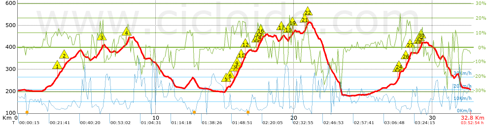
Distance in Km: 32.78
Climb in m: 1124
IBP: 109 BYC

Near ...
Andarujo, Artosa (Langreo), Barraca, La (Ciaño-Langreo), Barraca, La (Langreo), Barripies, Barros
Eduluna
Author: Eduluna
428 published routes

Add to my Group or Club

 Height in m      Climb in %      Speed in Km/h      Speed < 2 Km/h

Climbs > 10%

Climbs >5% Climbs >10% Climbs >15% Climbs >20% Climbs >25%
 Steep slope of 318 m.   Average slope  Distances  Download as waypoint
1
 Km 2.909  11%  170 m
2
 Km 3.337  11%  148 m
 Steep slope of 112 m.  Average slope  Distances  Download as waypoint
3
 Km 6.097  14%  112 m
 Steep slope of 186 m.  Average slope  Distances  Download as waypoint
4
 Km 7.895  15%  186 m
 Steep slope of 114 m.  Average slope  Distances  Download as waypoint
5
 Km 15.014  13%  114 m
 Steep slope of 1091 m.  Average slope  Distances  Download as waypoint
6
 Km 15.417  12%  281 m
7
 Km 15.697  10%  99 m
8
 Km 15.796  12%  112 m
9
 Km 15.908  17%  154 m
10
 Km 16.168  12%  33 m
11
 Km 16.201  17%  111 m
12
 Km 16.312  13%  294 m
 Steep slope of 366 m.  Average slope  Distances  Download as waypoint
13
 Km 17.29  10%  32 m
14
 Km 17.322  16%  110 m
15
 Km 17.433  11%  108 m
16
 Km 17.541  16%  116 m
 Steep slope of 107 m.  Average slope  Distances  Download as waypoint
17
 Km 19.08  14%  107 m
 Steep slope of 112 m.  Average slope  Distances  Download as waypoint
18
 Km 19.605  17%  112 m
 Steep slope of 109 m.  Average slope  Distances  Download as waypoint
19
 Km 19.843  15%  109 m
 Steep slope of 286 m.  Average slope  Distances  Download as waypoint
20
 Km 20.718  12%  63 m
21
 Km 20.782  16%  142 m
22
 Km 20.924  12%  81 m
 Steep slope of 754 m.  Average slope  Distances  Download as waypoint
23
 Km 27.427  11%  101 m
24
 Km 27.528  19%  179 m
25
 Km 28.051  12%  38 m
26
 Km 28.089  16%  245 m
27
 Km 28.334  15%  151 m
 Steep slope of 274 m.  Average slope  Distances  Download as waypoint
28
 Km 28.959  12%  109 m
29
 Km 29.068  14%  127 m
30
 Km 29.195  17%  38 m


Description of the route


Presence of ramps


 Climbs  Distance  % of the total  Speed  Your speed would be  Time  Your time would be
   15 - 30%  1.688  5.15  4.85  ?  0:20:52  ?
   10 - 15%  2.524  7.7  5.65  ?  0:26:49  ?
   5 - 10%  5.408  16.5  7.28  ?  0:44:36  ?
   1 - 5%  4.502  13.74  10.6  ?  0:25:29  ?
   Total*  14.122 Km  43.09 %  7.19 Km/h  ? Km/h    1:57:46 h  ? h  
 Flat
   1 - -1%  6.16 Km  18.8 %  14.03 Km/h  ? Km/h    0:26:21 h  ? h  
 Descents
   -1 - -5%  4.303  13.13  14.46  ?  0:17:51  ?
   -5 - -10%  2.972  9.07  17.17  ?  0:10:23  ?
   -10 - -15%  3  9.15  16.37  ?  0:11:00  ?
   -15 - -30%  2.219  6.77  16.89  ?  0:07:53  ?
   Total*  12.494 Km  38.12 %  15.91 Km/h  ? Km/h    0:47:07 h  ? h  
* The total has not necessarily coincide with the sum of the partials after correction of errors

How long would it take you?

How long would it take you to cover this route?
There are routes without a valid time information, but with your average stats you can assess the possible duration

Eduluna to cover this route you've need a time of:   3:11:14 h 
If you sign in and have a minimum of two tracks of this same modality, you can know your time for this route, calculated from your stats..


¿Cuanto consumirá tu E-BIKE?

Entra tu E-IBP (formato n,nn)

E-IBP :   X 109 = 


 Detected activity type =  ()
 Penalization due to track conditions: 73 %   ( > 50 % = MTB, < 50 % = RDB)
 Reliability of the track: B   (1123/71/0/-/-/71)
 Correction level applied to the track: 0
DIFFICULTY OF THE ROUTE
IBP = 109 BYC
According to your statistics
 Your time in motion would be: ? h
Your average speed would be: ? Km/h
 

 Total Distance: 32.78 Km
 Analysed distance: 32.78 Km
 Linear distance: 0.27 Km

 Cumulated positive ramps: 1123.6 m  list of points info
 Cumulated negative ramps: 1117.4 m
 Maximum height: 513.2 m
 Minimum height: 178.6 m
 Climbing Ratio: 7.96 %
 Descent ratio: 8.94 %
 Cumulated postive ramps per Km: 34.28 m
 Cumulated negative ramps per Km: 34.09 m

 Total time: 3:52:54 h
 Time in movement: 3:11:14 h
 According to your statistics
 Your time in motion would be: ? h  
 Stopped time: 0:41:40 h
 Maximum slope filter: ~30 %
 Minimum separation analysed: ~30 m
 Number of points: 1908   (cad. 17.18 m)
 Significant waypoints: 839   (cad. 39.07 m / 43.97 %)

 Changes in direction per Km: 11.1
 Changes in direction > 5º por Km: 8.39
 Cumulated straight stretches: 4.97 Km
 Straight stretches per Km: 151.62 m
 Penalized slope changes: 10
 Penalized slope changes per Km: 0.305

 Average speed in total: 8.44 Km/h
 Average speed while moving: 10.28 Km/h
 According to your statistics
 Your average speed would be: ? Km/h  
 Maximum sustained speed: 47.39 Km/h


Comments

You can be the first one in commenting this route

 
My comments
:
Add comment  (Registered users)
 
Notify me answers to my comment  Do not notify answers to my comment


Share this route with a friend

Your friend will receive a message with a link to this page:
will see your email and your user name if you do it as registered user.


Write here your name (optional)

E-mail address of your friend(s). You can include various addresses separated by commas

Text or comment (optional) maximum 255 characters long, 255 Available characters

As a non registered users you need to fill-in the captcha text.
  Change image
Type the image characters.
 
 Share with a friend


Visited history

Delete history

Marked routes for review later or compare

My favorites


  Notify anomaly in this route Share in Facebook