Pullosa / Collsuspina

Road
Road
Ref..: 1111107
Published: 14/07/2023
Performed: 13/07/2023
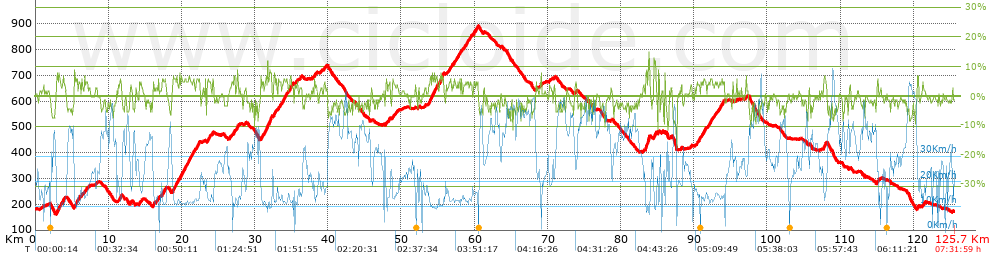
Distance in Km: 125.66
Climb in m: 1874
IBP: 128 BYC

Santi Dongil Diaz
926 published routes

Add to my Group or Club

 Height in m      Climb in %      Speed in Km/h      Speed < 2 Km/h

Climbs > 5%

Climbs >5% Climbs >10% Climbs >15% Climbs >20% Climbs >25%
 Steep slope of 354 m.   Average slope  Distances  Download as waypoint
1
 Km 2.939  6%  354 m
 Steep slope of 132 m.  Average slope  Distances  Download as waypoint
2
 Km 3.433  5%  132 m
 Steep slope of 144 m.  Average slope  Distances  Download as waypoint
3
 Km 3.769  6%  144 m
 Steep slope of 283 m.  Average slope  Distances  Download as waypoint
4
 Km 5.343  6%  283 m
 Steep slope of 101 m.  Average slope  Distances  Download as waypoint
5
 Km 5.982  5%  101 m
 Steep slope of 113 m.  Average slope  Distances  Download as waypoint
6
 Km 6.689  5%  113 m
 Steep slope of 209 m.  Average slope  Distances  Download as waypoint
7
 Km 11.553  6%  209 m
 Steep slope of 108 m.  Average slope  Distances  Download as waypoint
8
 Km 12.952  5%  108 m
 Steep slope of 111 m.  Average slope  Distances  Download as waypoint
9
 Km 16.099  6%  111 m
 Steep slope of 107 m.  Average slope  Distances  Download as waypoint
10
 Km 16.803  8%  107 m
 Steep slope of 389 m.  Average slope  Distances  Download as waypoint
11
 Km 17.342  6%  389 m
 Steep slope of 374 m.  Average slope  Distances  Download as waypoint
12
 Km 18.789  6%  374 m
 Steep slope of 132 m.  Average slope  Distances  Download as waypoint
13
 Km 19.304  5%  132 m
 Steep slope of 304 m.  Average slope  Distances  Download as waypoint
14
 Km 19.907  6%  304 m
 Steep slope of 202 m.  Average slope  Distances  Download as waypoint
15
 Km 20.308  5%  202 m
 Steep slope of 527 m.  Average slope  Distances  Download as waypoint
16
 Km 20.643  6%  527 m
 Steep slope of 102 m.  Average slope  Distances  Download as waypoint
17
 Km 21.266  5%  102 m
 Steep slope of 173 m.  Average slope  Distances  Download as waypoint
18
 Km 21.467  5%  173 m
 Steep slope of 101 m.  Average slope  Distances  Download as waypoint
19
 Km 22.021  6%  101 m
 Steep slope of 242 m.  Average slope  Distances  Download as waypoint
20
 Km 23.637  5%  242 m
 Steep slope of 191 m.  Average slope  Distances  Download as waypoint
21
 Km 27.106  6%  191 m
 Steep slope of 110 m.  Average slope  Distances  Download as waypoint
22
 Km 27.581  7%  110 m
 Steep slope of 107 m.  Average slope  Distances  Download as waypoint
23
 Km 30.829  6%  107 m
 Steep slope of 392 m.  Average slope  Distances  Download as waypoint
24
 Km 31.409  7%  392 m
 Steep slope of 398 m.  Average slope  Distances  Download as waypoint
25
 Km 31.939  8%  398 m
 Steep slope of 271 m.  Average slope  Distances  Download as waypoint
26
 Km 32.551  6%  271 m
 Steep slope of 254 m.  Average slope  Distances  Download as waypoint
27
 Km 33.246  5%  254 m
 Steep slope of 543 m.  Average slope  Distances  Download as waypoint
28
 Km 33.766  6%  543 m
 Steep slope of 103 m.  Average slope  Distances  Download as waypoint
29
 Km 34.413  6%  103 m
 Steep slope of 241 m.  Average slope  Distances  Download as waypoint
30
 Km 34.755  6%  241 m
 Steep slope of 114 m.  Average slope  Distances  Download as waypoint
31
 Km 38.121  6%  114 m
 Steep slope of 121 m.  Average slope  Distances  Download as waypoint
32
 Km 47.886  7%  121 m
 Steep slope of 750 m.  Average slope  Distances  Download as waypoint
33
 Km 53.786  6%  750 m
 Steep slope of 288 m.  Average slope  Distances  Download as waypoint
34
 Km 54.679  6%  288 m
 Steep slope of 595 m.  Average slope  Distances  Download as waypoint
35
 Km 55.219  6%  595 m
 Steep slope of 107 m.  Average slope  Distances  Download as waypoint
36
 Km 57.156  5%  107 m
 Steep slope of 102 m.  Average slope  Distances  Download as waypoint
37
 Km 57.753  5%  102 m
 Steep slope of 103 m.  Average slope  Distances  Download as waypoint
38
 Km 57.99  6%  103 m
 Steep slope of 107 m.  Average slope  Distances  Download as waypoint
39
 Km 59.001  5%  107 m
 Steep slope of 189 m.  Average slope  Distances  Download as waypoint
40
 Km 59.855  6%  189 m
 Steep slope of 150 m.  Average slope  Distances  Download as waypoint
41
 Km 60.263  5%  150 m
 Steep slope of 199 m.  Average slope  Distances  Download as waypoint
42
 Km 83.412  10%  199 m
 Steep slope of 275 m.  Average slope  Distances  Download as waypoint
43
 Km 83.712  10%  275 m
 Steep slope of 208 m.  Average slope  Distances  Download as waypoint
44
 Km 84.544  8%  208 m
 Steep slope of 106 m.  Average slope  Distances  Download as waypoint
45
 Km 85.105  8%  106 m
 Steep slope of 122 m.  Average slope  Distances  Download as waypoint
46
 Km 90.651  5%  122 m
 Steep slope of 109 m.  Average slope  Distances  Download as waypoint
47
 Km 90.871  5%  109 m
 Steep slope of 146 m.  Average slope  Distances  Download as waypoint
48
 Km 91.319  6%  146 m
 Steep slope of 135 m.  Average slope  Distances  Download as waypoint
49
 Km 92.196  5%  135 m
 Steep slope of 153 m.  Average slope  Distances  Download as waypoint
50
 Km 93.405  5%  153 m
 Steep slope of 189 m.  Average slope  Distances  Download as waypoint
51
 Km 93.668  5%  189 m
 Steep slope of 116 m.  Average slope  Distances  Download as waypoint
52
 Km 93.972  5%  116 m
 Steep slope of 263 m.  Average slope  Distances  Download as waypoint
53
 Km 107.706  6%  263 m
 Steep slope of 211 m.  Average slope  Distances  Download as waypoint
54
 Km 115.004  6%  211 m
 Steep slope of 153 m.  Average slope  Distances  Download as waypoint
55
 Km 120.516  8%  153 m


Description of the route


Presence of ramps


 Climbs  Distance  % of the total  Speed  Your speed would be  Time  Your time would be
   15 - 30%  0  0  0  ?  0:00:00  ?
   10 - 15%  0.419  0.33  7.5  ?  0:03:21  ?
   5 - 10%  14.203  11.3  13.11  ?  1:04:59  ?
   1 - 5%  31.241  24.86  16.48  ?  1:53:44  ?
   Total*  45.862 Km  36.5 %  15.11 Km/h  ? Km/h    3:02:04 h  ? h  
 Flat
   1 - -1%  27.573 Km  21.94 %  25 Km/h  ? Km/h    1:06:11 h  ? h  
 Descents
   -1 - -5%  40.62  32.32  34.83  ?  1:09:59  ?
   -5 - -10%  10.993  8.75  43.02  ?  0:15:20  ?
   -10 - -15%  0.51  0.41  35.3  ?  0:00:52  ?
   -15 - -30%  0.105  0.08  9.42  ?  0:00:40  ?
   Total*  52.228 Km  41.56 %  36.08 Km/h  ? Km/h    1:26:51 h  ? h  
* The total has not necessarily coincide with the sum of the partials after correction of errors

How long would it take you?

How long would it take you to cover this route?
There are routes without a valid time information, but with your average stats you can assess the possible duration

Santi Dongil Diaz to cover this route you've need a time of:   5:35:06 h 
If you sign in and have a minimum of two tracks of this same modality, you can know your time for this route, calculated from your stats..


¿Cuanto consumirá tu E-BIKE?

Entra tu E-IBP (formato n,nn)

E-IBP :   X 128 = 


 Detected activity type =  ()
 Penalization due to track conditions: 45 %   ( > 50 % = MTB, < 50 % = RDB)
 Reliability of the track: A   (1873/78/0/-/-/78)
 Correction level applied to the track: 0
DIFFICULTY OF THE ROUTE
IBP = 128 BYC
According to your statistics
 Your time in motion would be: ? h
Your average speed would be: ? Km/h
 

 Total Distance: 125.66 Km
 Analysed distance: 125.66 Km
 Linear distance: 0.04 Km

 Cumulated positive ramps: 1873.8 m  list of points info
 Cumulated negative ramps: 1875.6 m
 Maximum height: 892 m
 Minimum height: 162.2 m
 Climbing Ratio: 4.09 %
 Descent ratio: 3.59 %
 Cumulated postive ramps per Km: 14.91 m
 Cumulated negative ramps per Km: 14.93 m

 Total time: 7:31:59 h
 Time in movement: 5:35:06 h
 According to your statistics
 Your time in motion would be: ? h  
 Stopped time: 1:56:53 h
 Maximum slope filter: ~30 %
 Minimum separation analysed: ~30 m
 Number of points: 9509   (cad. 13.22 m)
 Significant waypoints: 3492   (cad. 35.99 m / 36.72 %)

 Changes in direction per Km: 9.09
 Changes in direction > 5º por Km: 5.24
 Cumulated straight stretches: 43.696 Km
 Straight stretches per Km: 347.73 m
 Penalized slope changes: 20
 Penalized slope changes per Km: 0.159

 Average speed in total: 16.68 Km/h
 Average speed while moving: 22.5 Km/h
 According to your statistics
 Your average speed would be: ? Km/h  
 Maximum sustained speed: 61.35 Km/h


Comments

You can be the first one in commenting this route

 
My comments
:
Add comment  (Registered users)
 
Notify me answers to my comment  Do not notify answers to my comment


Share this route with a friend

Your friend will receive a message with a link to this page:
will see your email and your user name if you do it as registered user.


Write here your name (optional)

E-mail address of your friend(s). You can include various addresses separated by commas

Text or comment (optional) maximum 255 characters long, 255 Available characters

As a non registered users you need to fill-in the captcha text.
  Change image
Type the image characters.
 
 Share with a friend


Visited history

Delete history

Marked routes for review later or compare

My favorites


  Notify anomaly in this route Share in Facebook