Cretes du Colombier

Hiking
Hiking
Ref..: 1102905
Published: 19/05/2023
Performed: 18/05/2023
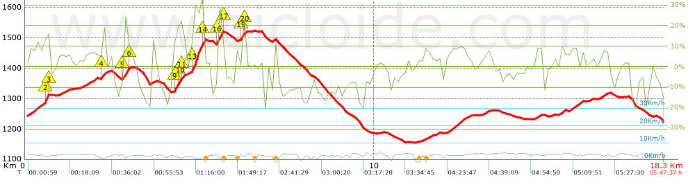
Distance in Km: 18.28
Climb in m: 718
IBP: 77 HKG

Autor 33750
Author: Autor 33750
206 published routes

Add to my Group or Club

 Height in m      Climb in %      Speed in Km/h      Speed < 2 Km/h

Climbs > 5%

Climbs >5% Climbs >10% Climbs >15% Climbs >20% Climbs >25%
 Steep slope of 616 m.   Average slope  Distances  Download as waypoint
1
 Km 0.097  9%  422 m
2
 Km 0.519  12%  33 m
3
 Km 0.551  22%  98 m
4
 Km 0.649  16%  32 m
5
 Km 0.681  6%  31 m
 Steep slope of 229 m.  Average slope  Distances  Download as waypoint
6
 Km 0.976  6%  229 m
 Steep slope of 417 m.  Average slope  Distances  Download as waypoint
7
 Km 1.581  7%  417 m
 Steep slope of 221 m.  Average slope  Distances  Download as waypoint
8
 Km 2.125  8%  61 m
9
 Km 2.186  14%  125 m
10
 Km 2.312  10%  35 m
 Steep slope of 200 m.  Average slope  Distances  Download as waypoint
11
 Km 2.795  24%  135 m
12
 Km 2.93  11%  32 m
13
 Km 2.962  8%  33 m
 Steep slope of 100 m.  Average slope  Distances  Download as waypoint
14
 Km 3.609  11%  100 m
 Steep slope of 826 m.  Average slope  Distances  Download as waypoint
15
 Km 4.249  11%  31 m
16
 Km 4.28  19%  32 m
17
 Km 4.312  22%  94 m
18
 Km 4.406  20%  94 m
19
 Km 4.5  13%  66 m
20
 Km 4.565  5%  156 m
21
 Km 4.721  13%  64 m
22
 Km 4.785  28%  259 m
23
 Km 5.044  34%  30 m
 Steep slope of 196 m.  Average slope  Distances  Download as waypoint
24
 Km 5.483  15%  32 m
25
 Km 5.515  26%  130 m
26
 Km 5.645  12%  34 m
 Steep slope of 34 m.  Average slope  Distances  Download as waypoint
27
 Km 6.032  8%  34 m
 Steep slope of 94 m.  Average slope  Distances  Download as waypoint
28
 Km 6.166  16%  32 m
29
 Km 6.198  20%  31 m
30
 Km 6.23  23%  31 m
 Steep slope of 223 m.  Average slope  Distances  Download as waypoint
31
 Km 11.398  7%  223 m
 Steep slope of 98 m.  Average slope  Distances  Download as waypoint
32
 Km 11.752  6%  98 m
 Steep slope of 614 m.  Average slope  Distances  Download as waypoint
33
 Km 12.07  9%  614 m
 Steep slope of 163 m.  Average slope  Distances  Download as waypoint
34
 Km 13.138  7%  163 m
 Steep slope of 193 m.  Average slope  Distances  Download as waypoint
35
 Km 14.589  8%  193 m
 Steep slope of 162 m.  Average slope  Distances  Download as waypoint
36
 Km 15.277  9%  162 m
 Steep slope of 381 m.  Average slope  Distances  Download as waypoint
37
 Km 15.537  8%  381 m
 Steep slope of 256 m.  Average slope  Distances  Download as waypoint
38
 Km 16.46  8%  256 m


Description of the route


Presence of ramps


 Climbs  Distance  % of the total  Speed  Your speed would be  Time  Your time would be
   15 - 30%  1.158  6.33  3.02  ?  0:23:01  ?
   10 - 15%  0.811  4.44  4.21  ?  0:11:33  ?
   5 - 10%  3.282  17.95  4.48  ?  0:43:55  ?
   1 - 5%  2.549  13.94  4.6  ?  0:33:14  ?
   Total*  7.929 Km  43.36 %  4.11 Km/h  ? Km/h    1:55:39 h  ? h  
 Flat
   1 - -1%  2.023 Km  11.06 %  4.5 Km/h  ? Km/h    0:27:00 h  ? h  
 Descents
   -1 - -5%  2.594  14.19  4.06  ?  0:38:18  ?
   -5 - -10%  2.475  13.53  4.38  ?  0:33:54  ?
   -10 - -15%  2.203  12.05  3.87  ?  0:34:08  ?
   -15 - -30%  1.028  5.62  3.43  ?  0:17:59  ?
   Total*  8.333 Km  45.57 %  4 Km/h  ? Km/h    2:04:53 h  ? h  
* The total has not necessarily coincide with the sum of the partials after correction of errors

How long would it take you?

How long would it take you to cover this route?
There are routes without a valid time information, but with your average stats you can assess the possible duration

Autor 33750 to cover this route you've need a time of:   4:27:32 h 
If you sign in and have a minimum of two tracks of this same modality, you can know your time for this route, calculated from your stats..


 Detected activity type =  ()
 Penalization due to track conditions: 0 %   ( > 50 % = MTB, < 50 % = RDB)
 Reliability of the track: B   (718/60/0/-/-/60)
 Correction level applied to the track: 0
DIFFICULTY OF THE ROUTE
IBP = 77 HKG
According to your statistics
 Your time in motion would be: ? h
Your average speed would be: ? Km/h
 

 Total Distance: 18.28 Km
 Analysed distance: 18.28 Km
 Linear distance: 0.27 Km

 Cumulated positive ramps: 717.93 m  list of points info
 Cumulated negative ramps: 738.43 m
 Maximum height: 1523.4 m
 Minimum height: 1155.3 m
 Climbing Ratio: 9.05 %
 Descent ratio: 8.86 %
 Cumulated postive ramps per Km: 39.27 m
 Cumulated negative ramps per Km: 40.4 m

 Total time: 5:47:37 h
 Time in movement: 4:27:32 h
 According to your statistics
 Your time in motion would be: ? h  
 Stopped time: 1:20:05 h
 Maximum slope filter: ~55 %
 Minimum separation analysed: ~30 m
 Number of points: 1719   (cad. 10.64 m)
 Significant waypoints: 567   (cad. 32.25 m / 32.98 %)

 Changes in direction per Km: 15.15
 Changes in direction > 5º por Km: 9.25
 Cumulated straight stretches: 4.101 Km
 Straight stretches per Km: 224.34 m
 Penalized slope changes: 6
 Penalized slope changes per Km: 0.328

 Average speed in total: 3.16 Km/h
 Average speed while moving: 4.1 Km/h
 According to your statistics
 Your average speed would be: ? Km/h  
 Maximum sustained speed: 6.65 Km/h


Comments

You can be the first one in commenting this route

 
My comments
:
Add comment  (Registered users)
 
Notify me answers to my comment  Do not notify answers to my comment


Share this route with a friend

Your friend will receive a message with a link to this page:
will see your email and your user name if you do it as registered user.


Write here your name (optional)

E-mail address of your friend(s). You can include various addresses separated by commas

Text or comment (optional) maximum 255 characters long, 255 Available characters

As a non registered users you need to fill-in the captcha text.
  Change image
Type the image characters.
 
 Share with a friend


Visited history

Delete history

Marked routes for review later or compare

My favorites


  Notify anomaly in this route Share in Facebook