Serralada Litoral

MTB
MTB
Ref..: 1102418
Published: 15/05/2023
Performed: 14/05/2023
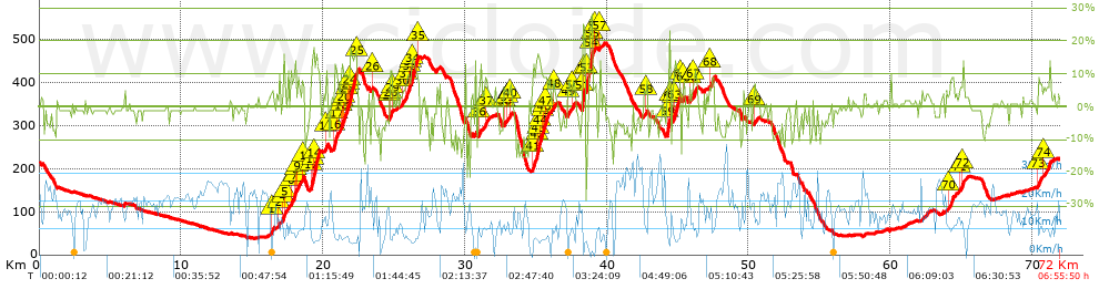
Distance in Km: 72.01
Climb in m: 1624
IBP: 132 BYC


 Height in m      Climb in %      Speed in Km/h      Speed < 2 Km/h

Climbs > 5%

Climbs >5% Climbs >10% Climbs >15% Climbs >20% Climbs >25%
 Steep slope of 170 m.   Average slope  Distances  Download as waypoint
1
 Km 16.361  7%  170 m
 Steep slope of 104 m.  Average slope  Distances  Download as waypoint
2
 Km 16.891  9%  104 m
 Steep slope of 236 m.  Average slope  Distances  Download as waypoint
3
 Km 17.163  7%  34 m
4
 Km 17.197  13%  100 m
5
 Km 17.297  6%  102 m
 Steep slope of 314 m.  Average slope  Distances  Download as waypoint
6
 Km 17.749  7%  209 m
7
 Km 17.957  14%  105 m
 Steep slope of 307 m.  Average slope  Distances  Download as waypoint
8
 Km 18.096  5%  96 m
9
 Km 18.192  7%  211 m
 Steep slope of 110 m.  Average slope  Distances  Download as waypoint
10
 Km 18.542  9%  110 m
 Steep slope of 653 m.  Average slope  Distances  Download as waypoint
11
 Km 19.126  8%  33 m
12
 Km 19.16  13%  99 m
13
 Km 19.259  17%  125 m
14
 Km 19.384  14%  396 m
 Steep slope of 158 m.  Average slope  Distances  Download as waypoint
15
 Km 20.169  8%  158 m
 Steep slope of 333 m.  Average slope  Distances  Download as waypoint
16
 Km 20.755  13%  203 m
17
 Km 20.959  8%  130 m
 Steep slope of 1267 m.  Average slope  Distances  Download as waypoint
18
 Km 21.22  8%  104 m
19
 Km 21.324  10%  132 m
20
 Km 21.456  10%  201 m
21
 Km 21.656  10%  102 m
22
 Km 21.758  6%  34 m
23
 Km 21.792  11%  97 m
24
 Km 21.889  14%  463 m
25
 Km 22.353  9%  134 m
 Steep slope of 100 m.  Average slope  Distances  Download as waypoint
26
 Km 23.469  7%  100 m
 Steep slope of 195 m.  Average slope  Distances  Download as waypoint
27
 Km 24.695  9%  31 m
28
 Km 24.726  11%  131 m
29
 Km 24.857  10%  33 m
 Steep slope of 138 m.  Average slope  Distances  Download as waypoint
30
 Km 25.599  6%  138 m
 Steep slope of 927 m.  Average slope  Distances  Download as waypoint
31
 Km 25.838  9%  199 m
32
 Km 26.037  12%  95 m
33
 Km 26.132  6%  100 m
34
 Km 26.232  13%  401 m
35
 Km 26.633  8%  132 m
 Steep slope of 132 m.  Average slope  Distances  Download as waypoint
36
 Km 31.006  6%  132 m
 Steep slope of 142 m.  Average slope  Distances  Download as waypoint
37
 Km 31.421  9%  142 m
 Steep slope of 103 m.  Average slope  Distances  Download as waypoint
38
 Km 32.738  6%  103 m
 Steep slope of 103 m.  Average slope  Distances  Download as waypoint
39
 Km 32.944  6%  103 m
 Steep slope of 98 m.  Average slope  Distances  Download as waypoint
40
 Km 33.182  7%  98 m
 Steep slope of 1222 m.  Average slope  Distances  Download as waypoint
41
 Km 34.715  8%  306 m
42
 Km 35.021  14%  98 m
43
 Km 35.119  17%  98 m
44
 Km 35.217  12%  240 m
45
 Km 35.458  9%  99 m
46
 Km 35.557  12%  142 m
47
 Km 35.699  9%  239 m
 Steep slope of 141 m.  Average slope  Distances  Download as waypoint
48
 Km 36.233  7%  141 m
 Steep slope of 170 m.  Average slope  Distances  Download as waypoint
49
 Km 37.282  7%  170 m
 Steep slope of 206 m.  Average slope  Distances  Download as waypoint
50
 Km 37.597  7%  206 m
 Steep slope of 242 m.  Average slope  Distances  Download as waypoint
51
 Km 38.269  13%  38 m
52
 Km 38.307  24%  204 m
 Steep slope of 439 m.  Average slope  Distances  Download as waypoint
53
 Km 38.612  11%  31 m
54
 Km 38.643  27%  343 m
55
 Km 38.986  6%  65 m
 Steep slope of 137 m.  Average slope  Distances  Download as waypoint
56
 Km 39.149  6%  137 m
 Steep slope of 97 m.  Average slope  Distances  Download as waypoint
57
 Km 39.488  9%  97 m
 Steep slope of 104 m.  Average slope  Distances  Download as waypoint
58
 Km 42.764  7%  104 m
 Steep slope of 253 m.  Average slope  Distances  Download as waypoint
59
 Km 44.254  15%  188 m
60
 Km 44.442  23%  33 m
61
 Km 44.475  15%  32 m
 Steep slope of 477 m.  Average slope  Distances  Download as waypoint
62
 Km 44.683  7%  70 m
63
 Km 44.753  12%  372 m
64
 Km 45.125  10%  35 m
 Steep slope of 143 m.  Average slope  Distances  Download as waypoint
65
 Km 45.37  7%  143 m
 Steep slope of 102 m.  Average slope  Distances  Download as waypoint
66
 Km 45.834  6%  102 m
 Steep slope of 278 m.  Average slope  Distances  Download as waypoint
67
 Km 46.041  8%  278 m
 Steep slope of 344 m.  Average slope  Distances  Download as waypoint
68
 Km 47.228  7%  344 m
 Steep slope of 110 m.  Average slope  Distances  Download as waypoint
69
 Km 50.38  6%  110 m
 Steep slope of 335 m.  Average slope  Distances  Download as waypoint
70
 Km 64.076  7%  335 m
 Steep slope of 313 m.  Average slope  Distances  Download as waypoint
71
 Km 64.885  6%  211 m
72
 Km 65.096  12%  102 m
 Steep slope of 280 m.  Average slope  Distances  Download as waypoint
73
 Km 70.402  8%  280 m
 Steep slope of 415 m.  Average slope  Distances  Download as waypoint
74
 Km 70.781  5%  415 m


Description of the route


Presence of ramps


 Climbs  Distance  % of the total  Speed  Your speed would be  Time  Your time would be
   15 - 30%  1.607  2.23  5.65  ?  0:17:04  ?
   10 - 15%  3.543  4.92  7.41  ?  0:28:42  ?
   5 - 10%  6.958  9.66  9.5  ?  0:43:58  ?
   1 - 5%  13.725  19.06  12.6  ?  1:05:22  ?
   Total*  25.833 Km  35.88 %  9.99 Km/h  ? Km/h    2:35:06 h  ? h  
 Flat
   1 - -1%  18.866 Km  26.2 %  17.78 Km/h  ? Km/h    1:03:40 h  ? h  
 Descents
   -1 - -5%  13.97  19.4  18.21  ?  0:46:02  ?
   -5 - -10%  8.97  12.46  17.35  ?  0:31:01  ?
   -10 - -15%  3.213  4.46  17.88  ?  0:10:47  ?
   -15 - -30%  1.156  1.61  9.5  ?  0:07:18  ?
   Total*  27.309 Km  37.92 %  17.22 Km/h  ? Km/h    1:35:08 h  ? h  
* The total has not necessarily coincide with the sum of the partials after correction of errors

How long would it take you?

How long would it take you to cover this route?
There are routes without a valid time information, but with your average stats you can assess the possible duration

Manolo Gonzalez Gomez to cover this route you've need a time of:   5:13:54 h 
If you sign in and have a minimum of two tracks of this same modality, you can know your time for this route, calculated from your stats..


¿Cuanto consumirá tu E-BIKE?

Entra tu E-IBP (formato n,nn)

E-IBP :   X 132 = 


 Detected activity type =  ()
 Penalization due to track conditions: 65 %   ( > 50 % = MTB, < 50 % = RDB)
 Reliability of the track: B   (1624/67/0/-/-/67)
 Correction level applied to the track: 0
DIFFICULTY OF THE ROUTE
IBP = 132 BYC
According to your statistics
 Your time in motion would be: ? h
Your average speed would be: ? Km/h
 

 Total Distance: 72.01 Km
 Analysed distance: 72.01 Km
 Linear distance: 0.16 Km

 Cumulated positive ramps: 1623.5 m  list of points info
 Cumulated negative ramps: 1581.4 m
 Maximum height: 492.3 m
 Minimum height: 38.4 m
 Climbing Ratio: 6.28 %
 Descent ratio: 5.79 %
 Cumulated postive ramps per Km: 22.55 m
 Cumulated negative ramps per Km: 21.96 m

 Total time: 6:55:50 h
 Time in movement: 5:13:54 h
 According to your statistics
 Your time in motion would be: ? h  
 Stopped time: 1:41:56 h
 Maximum slope filter: ~30 %
 Minimum separation analysed: ~30 m
 Number of points: 5819   (cad. 12.37 m)
 Significant waypoints: 2021   (cad. 35.63 m / 34.73 %)

 Changes in direction per Km: 10.9
 Changes in direction > 5º por Km: 7.15
 Cumulated straight stretches: 15.962 Km
 Straight stretches per Km: 221.66 m
 Penalized slope changes: 16
 Penalized slope changes per Km: 0.222

 Average speed in total: 10.39 Km/h
 Average speed while moving: 13.76 Km/h
 According to your statistics
 Your average speed would be: ? Km/h  
 Maximum sustained speed: 41.88 Km/h


Comments

You can be the first one in commenting this route

 
My comments
:
Add comment  (Registered users)
 
Notify me answers to my comment  Do not notify answers to my comment


Share this route with a friend

Your friend will receive a message with a link to this page:
will see your email and your user name if you do it as registered user.


Write here your name (optional)

E-mail address of your friend(s). You can include various addresses separated by commas

Text or comment (optional) maximum 255 characters long, 255 Available characters

As a non registered users you need to fill-in the captcha text.
  Change image
Type the image characters.
 
 Share with a friend


Visited history

Delete history

Marked routes for review later or compare

My favorites


  Notify anomaly in this route Share in Facebook