2023 04 13 mansos asadero camino neveros cantera purche hazallanas

MTB
MTB
Ref..: 1097309
Published: 14/04/2023
Performed: 13/04/2023
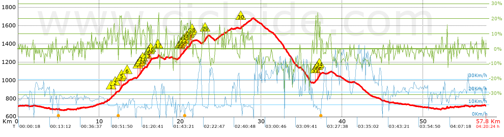
Distance in Km: 57.76
Climb in m: 1648
IBP: 145 BYC


 Height in m      Climb in %      Speed in Km/h      Speed < 2 Km/h

Climbs > 5%

Climbs >5% Climbs >10% Climbs >15% Climbs >20% Climbs >25%
 Steep slope of 131 m.   Average slope  Distances  Download as waypoint
1
 Km 1.784  6%  131 m
 Steep slope of 109 m.  Average slope  Distances  Download as waypoint
2
 Km 4.613  6%  109 m
 Steep slope of 143 m.  Average slope  Distances  Download as waypoint
3
 Km 7.155  6%  143 m
 Steep slope of 159 m.  Average slope  Distances  Download as waypoint
4
 Km 10.515  8%  159 m
 Steep slope of 363 m.  Average slope  Distances  Download as waypoint
5
 Km 10.96  7%  363 m
 Steep slope of 177 m.  Average slope  Distances  Download as waypoint
6
 Km 11.431  11%  142 m
7
 Km 11.573  14%  35 m
 Steep slope of 542 m.  Average slope  Distances  Download as waypoint
8
 Km 11.75  10%  216 m
9
 Km 11.966  10%  113 m
10
 Km 12.079  11%  213 m
 Steep slope of 652 m.  Average slope  Distances  Download as waypoint
11
 Km 12.428  7%  105 m
12
 Km 12.533  16%  102 m
13
 Km 12.635  13%  99 m
14
 Km 12.734  22%  99 m
15
 Km 12.833  7%  109 m
16
 Km 12.942  9%  138 m
 Steep slope of 693 m.  Average slope  Distances  Download as waypoint
17
 Km 13.187  7%  273 m
18
 Km 13.461  12%  131 m
19
 Km 13.591  5%  189 m
20
 Km 13.78  6%  100 m
 Steep slope of 219 m.  Average slope  Distances  Download as waypoint
21
 Km 13.987  5%  219 m
 Steep slope of 812 m.  Average slope  Distances  Download as waypoint
22
 Km 14.599  10%  136 m
23
 Km 14.735  11%  235 m
24
 Km 14.971  11%  101 m
25
 Km 15.072  15%  136 m
26
 Km 15.208  18%  33 m
27
 Km 15.241  9%  106 m
28
 Km 15.347  14%  65 m
 Steep slope of 234 m.  Average slope  Distances  Download as waypoint
29
 Km 15.507  10%  234 m
 Steep slope of 692 m.  Average slope  Distances  Download as waypoint
30
 Km 15.873  14%  35 m
31
 Km 15.907  16%  234 m
32
 Km 16.141  13%  102 m
33
 Km 16.243  12%  99 m
34
 Km 16.342  13%  140 m
35
 Km 16.481  9%  82 m
 Steep slope of 203 m.  Average slope  Distances  Download as waypoint
36
 Km 17.163  6%  70 m
37
 Km 17.233  21%  68 m
38
 Km 17.301  6%  32 m
39
 Km 17.333  24%  33 m
 Steep slope of 307 m.  Average slope  Distances  Download as waypoint
40
 Km 19.584  7%  275 m
41
 Km 19.859  13%  32 m
 Steep slope of 1569 m.  Average slope  Distances  Download as waypoint
42
 Km 19.992  20%  35 m
43
 Km 20.027  14%  99 m
44
 Km 20.126  10%  101 m
45
 Km 20.227  9%  139 m
46
 Km 20.366  13%  133 m
47
 Km 20.498  10%  309 m
48
 Km 20.808  13%  99 m
49
 Km 20.906  5%  149 m
50
 Km 21.055  11%  101 m
51
 Km 21.157  19%  101 m
52
 Km 21.258  12%  98 m
53
 Km 21.356  18%  66 m
54
 Km 21.423  11%  35 m
55
 Km 21.458  6%  104 m
 Steep slope of 722 m.  Average slope  Distances  Download as waypoint
56
 Km 22.717  10%  305 m
57
 Km 23.022  13%  317 m
58
 Km 23.34  14%  100 m
 Steep slope of 466 m.  Average slope  Distances  Download as waypoint
59
 Km 24.271  7%  466 m
 Steep slope of 229 m.  Average slope  Distances  Download as waypoint
60
 Km 24.839  8%  229 m
 Steep slope of 173 m.  Average slope  Distances  Download as waypoint
61
 Km 25.241  6%  173 m
 Steep slope of 250 m.  Average slope  Distances  Download as waypoint
62
 Km 25.657  8%  250 m
 Steep slope of 239 m.  Average slope  Distances  Download as waypoint
63
 Km 26.048  7%  239 m
 Steep slope of 107 m.  Average slope  Distances  Download as waypoint
64
 Km 26.789  9%  107 m
 Steep slope of 571 m.  Average slope  Distances  Download as waypoint
65
 Km 27.436  9%  33 m
66
 Km 27.469  12%  107 m
67
 Km 27.576  7%  219 m
68
 Km 27.795  8%  111 m
69
 Km 27.906  5%  101 m
 Steep slope of 238 m.  Average slope  Distances  Download as waypoint
70
 Km 28.113  9%  69 m
71
 Km 28.182  8%  136 m
72
 Km 28.318  12%  33 m
 Steep slope of 482 m.  Average slope  Distances  Download as waypoint
73
 Km 28.45  7%  482 m
 Steep slope of 697 m.  Average slope  Distances  Download as waypoint
74
 Km 36.582  8%  36 m
75
 Km 36.618  12%  139 m
76
 Km 36.757  8%  166 m
77
 Km 36.922  19%  162 m
78
 Km 37.084  12%  33 m
79
 Km 37.117  7%  96 m
80
 Km 37.212  22%  65 m
 Steep slope of 122 m.  Average slope  Distances  Download as waypoint
81
 Km 38.267  6%  122 m
 Steep slope of 155 m.  Average slope  Distances  Download as waypoint
82
 Km 52.195  8%  155 m


Description of the route


Presence of ramps


 Climbs  Distance  % of the total  Speed  Your speed would be  Time  Your time would be
   15 - 30%  2.426  4.2  8.63  ?  0:16:52  ?
   10 - 15%  2.925  5.06  10.04  ?  0:17:29  ?
   5 - 10%  8.413  14.56  11.44  ?  0:44:08  ?
   1 - 5%  7.984  13.82  15.95  ?  0:30:02  ?
   Total*  21.748 Km  37.65 %  12.02 Km/h  ? Km/h    1:48:31 h  ? h  
 Flat
   1 - -1%  10.764 Km  18.64 %  18.63 Km/h  ? Km/h    0:34:40 h  ? h  
 Descents
   -1 - -5%  10.774  18.65  22.67  ?  0:28:31  ?
   -5 - -10%  10.374  17.96  24.88  ?  0:25:01  ?
   -10 - -15%  3.017  5.22  24.63  ?  0:07:21  ?
   -15 - -30%  1.087  1.88  25.25  ?  0:02:35  ?
   Total*  25.252 Km  43.72 %  23.87 Km/h  ? Km/h    1:03:28 h  ? h  
* The total has not necessarily coincide with the sum of the partials after correction of errors

How long would it take you?

How long would it take you to cover this route?
There are routes without a valid time information, but with your average stats you can assess the possible duration

Armando_Rodriguez_Nieto to cover this route you've need a time of:   3:26:39 h 
If you sign in and have a minimum of two tracks of this same modality, you can know your time for this route, calculated from your stats..


¿Cuanto consumirá tu E-BIKE?

Entra tu E-IBP (formato n,nn)

E-IBP :   X 145 = 


 Detected activity type =  ()
 Penalization due to track conditions: 80 %   ( > 50 % = MTB, < 50 % = RDB)
 Reliability of the track: B   (1648/60/0/-/-/60)
 Correction level applied to the track: 0
DIFFICULTY OF THE ROUTE
IBP = 145 BYC
According to your statistics
 Your time in motion would be: ? h
Your average speed would be: ? Km/h
 

 Total Distance: 57.76 Km
 Analysed distance: 57.76 Km
 Linear distance: 0.2 Km

 Cumulated positive ramps: 1647.83 m  list of points info
 Cumulated negative ramps: 1639.83 m
 Maximum height: 1681 m
 Minimum height: 671 m
 Climbing Ratio: 7.58 %
 Descent ratio: 6.49 %
 Cumulated postive ramps per Km: 28.53 m
 Cumulated negative ramps per Km: 28.39 m

 Total time: 4:20:24 h
 Time in movement: 3:26:39 h
 According to your statistics
 Your time in motion would be: ? h  
 Stopped time: 0:53:45 h
 Maximum slope filter: ~30 %
 Minimum separation analysed: ~30 m
 Number of points: 4539   (cad. 12.73 m)
 Significant waypoints: 1600   (cad. 36.1 m / 35.25 %)

 Changes in direction per Km: 10.23
 Changes in direction > 5º por Km: 6.77
 Cumulated straight stretches: 13.522 Km
 Straight stretches per Km: 234.11 m
 Penalized slope changes: 11
 Penalized slope changes per Km: 0.19

 Average speed in total: 13.31 Km/h
 Average speed while moving: 16.77 Km/h
 According to your statistics
 Your average speed would be: ? Km/h  
 Maximum sustained speed: 59.02 Km/h


Comments

You can be the first one in commenting this route

 
My comments
:
Add comment  (Registered users)
 
Notify me answers to my comment  Do not notify answers to my comment


Share this route with a friend

Your friend will receive a message with a link to this page:
will see your email and your user name if you do it as registered user.


Write here your name (optional)

E-mail address of your friend(s). You can include various addresses separated by commas

Text or comment (optional) maximum 255 characters long, 255 Available characters

As a non registered users you need to fill-in the captcha text.
  Change image
Type the image characters.
 
 Share with a friend


Visited history

Delete history

Marked routes for review later or compare

My favorites


  Notify anomaly in this route Share in Facebook