Mollet-La Roca-Pedra foradada-Inicio bucle senderos-Coll de Parpers-Sant Carles-Final bucle Senderos...

MTB
MTB
Ref..: 1096852
Published: 11/04/2023
Performed: 10/04/2023
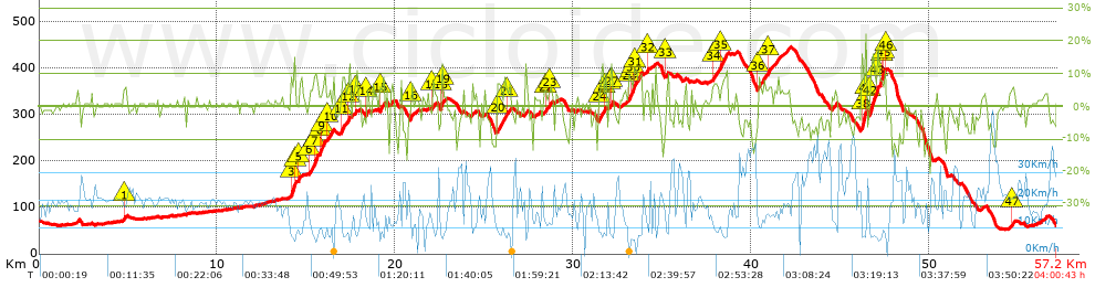
Distance in Km: 57.25
Climb in m: 1125
IBP: 88 BYC

Near ...
Conreria, La (Sant Fost Campcentelles), Florida, La, Gallecs, Llagosta, La, Martorelles, Mogoda

 Height in m      Climb in %      Speed in Km/h      Speed < 2 Km/h

Climbs > 5%

Climbs >5% Climbs >10% Climbs >15% Climbs >20% Climbs >25%
 Steep slope of 162 m.   Average slope  Distances  Download as waypoint
1
 Km 4.75  6%  162 m
 Steep slope of 292 m.  Average slope  Distances  Download as waypoint
2
 Km 14.13  8%  31 m
3
 Km 14.161  12%  197 m
4
 Km 14.358  12%  64 m
 Steep slope of 141 m.  Average slope  Distances  Download as waypoint
5
 Km 14.562  6%  141 m
 Steep slope of 452 m.  Average slope  Distances  Download as waypoint
6
 Km 15.151  6%  321 m
7
 Km 15.472  11%  131 m
 Steep slope of 258 m.  Average slope  Distances  Download as waypoint
8
 Km 15.776  9%  98 m
9
 Km 15.873  10%  160 m
 Steep slope of 234 m.  Average slope  Distances  Download as waypoint
10
 Km 16.181  7%  234 m
 Steep slope of 162 m.  Average slope  Distances  Download as waypoint
11
 Km 16.991  10%  162 m
 Steep slope of 133 m.  Average slope  Distances  Download as waypoint
12
 Km 17.328  9%  133 m
 Steep slope of 133 m.  Average slope  Distances  Download as waypoint
13
 Km 17.741  8%  133 m
 Steep slope of 104 m.  Average slope  Distances  Download as waypoint
14
 Km 18.379  8%  104 m
 Steep slope of 168 m.  Average slope  Distances  Download as waypoint
15
 Km 19.145  7%  168 m
 Steep slope of 133 m.  Average slope  Distances  Download as waypoint
16
 Km 20.904  9%  133 m
 Steep slope of 148 m.  Average slope  Distances  Download as waypoint
17
 Km 22.077  6%  148 m
 Steep slope of 169 m.  Average slope  Distances  Download as waypoint
18
 Km 22.561  12%  104 m
19
 Km 22.665  5%  65 m
 Steep slope of 374 m.  Average slope  Distances  Download as waypoint
20
 Km 25.747  7%  374 m
 Steep slope of 231 m.  Average slope  Distances  Download as waypoint
21
 Km 26.222  6%  231 m
 Steep slope of 102 m.  Average slope  Distances  Download as waypoint
22
 Km 28.466  5%  102 m
 Steep slope of 99 m.  Average slope  Distances  Download as waypoint
23
 Km 28.673  7%  99 m
 Steep slope of 168 m.  Average slope  Distances  Download as waypoint
24
 Km 31.487  9%  168 m
 Steep slope of 106 m.  Average slope  Distances  Download as waypoint
25
 Km 31.79  10%  106 m
 Steep slope of 140 m.  Average slope  Distances  Download as waypoint
26
 Km 32.047  5%  73 m
27
 Km 32.121  12%  67 m
 Steep slope of 652 m.  Average slope  Distances  Download as waypoint
28
 Km 33.143  10%  96 m
29
 Km 33.238  9%  164 m
30
 Km 33.402  11%  115 m
31
 Km 33.518  7%  277 m
 Steep slope of 135 m.  Average slope  Distances  Download as waypoint
32
 Km 34.13  6%  135 m
 Steep slope of 146 m.  Average slope  Distances  Download as waypoint
33
 Km 35.183  5%  146 m
 Steep slope of 345 m.  Average slope  Distances  Download as waypoint
34
 Km 37.83  6%  345 m
 Steep slope of 447 m.  Average slope  Distances  Download as waypoint
35
 Km 38.273  8%  447 m
 Steep slope of 198 m.  Average slope  Distances  Download as waypoint
36
 Km 40.386  7%  198 m
 Steep slope of 360 m.  Average slope  Distances  Download as waypoint
37
 Km 40.957  5%  360 m
 Steep slope of 265 m.  Average slope  Distances  Download as waypoint
38
 Km 46.217  15%  199 m
39
 Km 46.417  22%  33 m
40
 Km 46.45  18%  33 m
 Steep slope of 645 m.  Average slope  Distances  Download as waypoint
41
 Km 46.657  5%  40 m
42
 Km 46.696  12%  402 m
43
 Km 47.099  10%  203 m
 Steep slope of 207 m.  Average slope  Distances  Download as waypoint
44
 Km 47.402  8%  69 m
45
 Km 47.471  14%  104 m
46
 Km 47.575  6%  34 m
 Steep slope of 111 m.  Average slope  Distances  Download as waypoint
47
 Km 54.622  5%  111 m


Description of the route


Presence of ramps


 Climbs  Distance  % of the total  Speed  Your speed would be  Time  Your time would be
   15 - 30%  0.528  0.92  6.47  ?  0:04:54  ?
   10 - 15%  1.915  3.34  7.15  ?  0:16:04  ?
   5 - 10%  6.829  11.93  9.92  ?  0:41:18  ?
   1 - 5%  12.785  22.33  13.55  ?  0:56:36  ?
   Total*  22.057 Km  38.53 %  11.13 Km/h  ? Km/h    1:58:52 h  ? h  
 Flat
   1 - -1%  14.076 Km  24.59 %  19.34 Km/h  ? Km/h    0:43:40 h  ? h  
 Descents
   -1 - -5%  11.871  20.74  21.4  ?  0:33:17  ?
   -5 - -10%  6.702  11.71  22.98  ?  0:17:30  ?
   -10 - -15%  2.029  3.54  21.87  ?  0:05:34  ?
   -15 - -30%  0.515  0.9  16.4  ?  0:01:53  ?
   Total*  21.117 Km  36.89 %  21.76 Km/h  ? Km/h    0:58:14 h  ? h  
* The total has not necessarily coincide with the sum of the partials after correction of errors

How long would it take you?

How long would it take you to cover this route?
There are routes without a valid time information, but with your average stats you can assess the possible duration

Ramon Denuc-TempsMollet to cover this route you've need a time of:   3:40:46 h 
If you sign in and have a minimum of two tracks of this same modality, you can know your time for this route, calculated from your stats..


¿Cuanto consumirá tu E-BIKE?

Entra tu E-IBP (formato n,nn)

E-IBP :   X 88 = 


 Detected activity type =  ()
 Penalization due to track conditions: 71 %   ( > 50 % = MTB, < 50 % = RDB)
 Reliability of the track: C   (1125/56/0/-/-/56)
 Correction level applied to the track: 0
DIFFICULTY OF THE ROUTE
IBP = 88 BYC
According to your statistics
 Your time in motion would be: ? h
Your average speed would be: ? Km/h
 

 Total Distance: 57.25 Km
 Analysed distance: 57.25 Km
 Linear distance: 0.01 Km

 Cumulated positive ramps: 1124.63 m  list of points info
 Cumulated negative ramps: 1151.83 m
 Maximum height: 445 m
 Minimum height: 53 m
 Climbing Ratio: 5.1 %
 Descent ratio: 5.45 %
 Cumulated postive ramps per Km: 19.64 m
 Cumulated negative ramps per Km: 20.12 m

 Total time: 4:00:43 h
 Time in movement: 3:40:46 h
 According to your statistics
 Your time in motion would be: ? h  
 Stopped time: 0:19:57 h
 Maximum slope filter: ~30 %
 Minimum separation analysed: ~30 m
 Number of points: 3817   (cad. 15 m)
 Significant waypoints: 1505   (cad. 38.04 m / 39.43 %)

 Changes in direction per Km: 11.16
 Changes in direction > 5º por Km: 8.4
 Cumulated straight stretches: 11.427 Km
 Straight stretches per Km: 199.6 m
 Penalized slope changes: 10
 Penalized slope changes per Km: 0.175

 Average speed in total: 14.27 Km/h
 Average speed while moving: 15.56 Km/h
 According to your statistics
 Your average speed would be: ? Km/h  
 Maximum sustained speed: 50.61 Km/h


Comments

You can be the first one in commenting this route

 
My comments
:
Add comment  (Registered users)
 
Notify me answers to my comment  Do not notify answers to my comment


Share this route with a friend

Your friend will receive a message with a link to this page:
will see your email and your user name if you do it as registered user.


Write here your name (optional)

E-mail address of your friend(s). You can include various addresses separated by commas

Text or comment (optional) maximum 255 characters long, 255 Available characters

As a non registered users you need to fill-in the captcha text.
  Change image
Type the image characters.
 
 Share with a friend


Visited history

Delete history

Marked routes for review later or compare

My favorites


  Notify anomaly in this route Share in Facebook