Etapa 3. Sierra Espuña - Barranco de la Hoz - El Berro - Barrancos de Gebas.

MTB
MTB
Ref..: 1095625
Published: 04/04/2023
Performed: 04/04/2023
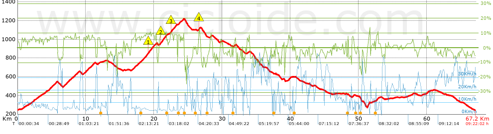
Distance in Km: 67.16
Climb in m: 1731
IBP: 105 BYC

Near ...
Alhama De Murcia, Azaraque, Collado, El (Espuña), Flotas, Las (Alhama De Murcia), Mojon, El (Alhama De Murcia), Moriana
Autor 19323
Author: Autor 19323
284 published routes

Add to my Group or Club

 Height in m      Climb in %      Speed in Km/h      Speed < 2 Km/h

Climbs > 5%

Climbs >5% Climbs >10% Climbs >15% Climbs >20% Climbs >25%
 Steep slope of 215 m.   Average slope  Distances  Download as waypoint
1
 Km 0.613  6%  215 m
 Steep slope of 119 m.  Average slope  Distances  Download as waypoint
2
 Km 1.042  5%  119 m
 Steep slope of 657 m.  Average slope  Distances  Download as waypoint
3
 Km 1.831  6%  657 m
 Steep slope of 372 m.  Average slope  Distances  Download as waypoint
4
 Km 2.675  6%  372 m
 Steep slope of 155 m.  Average slope  Distances  Download as waypoint
5
 Km 3.214  7%  155 m
 Steep slope of 155 m.  Average slope  Distances  Download as waypoint
6
 Km 3.492  5%  155 m
 Steep slope of 413 m.  Average slope  Distances  Download as waypoint
7
 Km 3.882  6%  413 m
 Steep slope of 1291 m.  Average slope  Distances  Download as waypoint
8
 Km 4.443  7%  1291 m
 Steep slope of 1746 m.  Average slope  Distances  Download as waypoint
9
 Km 6.655  7%  1746 m
 Steep slope of 505 m.  Average slope  Distances  Download as waypoint
10
 Km 8.548  7%  505 m
 Steep slope of 1681 m.  Average slope  Distances  Download as waypoint
11
 Km 9.594  7%  1681 m
 Steep slope of 326 m.  Average slope  Distances  Download as waypoint
12
 Km 11.731  7%  326 m
 Steep slope of 516 m.  Average slope  Distances  Download as waypoint
13
 Km 16.706  7%  516 m
 Steep slope of 2989 m.  Average slope  Distances  Download as waypoint
14
 Km 17.383  8%  1798 m
15
 Km 19.181  10%  121 m
16
 Km 19.302  9%  1070 m
 Steep slope of 1240 m.  Average slope  Distances  Download as waypoint
17
 Km 20.736  8%  264 m
18
 Km 21.001  10%  256 m
19
 Km 21.256  9%  720 m
 Steep slope of 1055 m.  Average slope  Distances  Download as waypoint
20
 Km 22.258  7%  171 m
21
 Km 22.429  10%  242 m
22
 Km 22.671  9%  642 m
 Steep slope of 289 m.  Average slope  Distances  Download as waypoint
23
 Km 23.533  9%  289 m
 Steep slope of 386 m.  Average slope  Distances  Download as waypoint
24
 Km 23.944  7%  386 m
 Steep slope of 341 m.  Average slope  Distances  Download as waypoint
25
 Km 26.489  9%  119 m
26
 Km 26.609  12%  95 m
27
 Km 26.704  8%  127 m
 Steep slope of 215 m.  Average slope  Distances  Download as waypoint
28
 Km 28.242  8%  215 m
 Steep slope of 155 m.  Average slope  Distances  Download as waypoint
29
 Km 29.71  6%  155 m
 Steep slope of 241 m.  Average slope  Distances  Download as waypoint
30
 Km 31.763  6%  241 m
 Steep slope of 309 m.  Average slope  Distances  Download as waypoint
31
 Km 33.642  6%  309 m
 Steep slope of 485 m.  Average slope  Distances  Download as waypoint
32
 Km 39.675  7%  485 m
 Steep slope of 300 m.  Average slope  Distances  Download as waypoint
33
 Km 49.047  7%  300 m
 Steep slope of 317 m.  Average slope  Distances  Download as waypoint
34
 Km 52.577  10%  317 m
 Steep slope of 123 m.  Average slope  Distances  Download as waypoint
35
 Km 57.898  6%  123 m
 Steep slope of 234 m.  Average slope  Distances  Download as waypoint
36
 Km 60.009  8%  234 m


Description of the route


Presence of ramps


 Climbs  Distance  % of the total  Speed  Your speed would be  Time  Your time would be
   15 - 30%  0.042  0.06  3.36  ?  0:00:45  ?
   10 - 15%  1.925  2.87  3.7  ?  0:31:11  ?
   5 - 10%  15.855  23.61  6.54  ?  2:25:22  ?
   1 - 5%  12.208  18.18  11.03  ?  1:06:26  ?
   Total*  30.03 Km  44.71 %  7.39 Km/h  ? Km/h    4:03:44 h  ? h  
 Flat
   1 - -1%  6.819 Km  10.15 %  16.71 Km/h  ? Km/h    0:24:29 h  ? h  
 Descents
   -1 - -5%  14.483  21.56  20.31  ?  0:42:47  ?
   -5 - -10%  12.501  18.61  19.9  ?  0:37:41  ?
   -10 - -15%  2.746  4.09  14.2  ?  0:11:36  ?
   -15 - -30%  0.586  0.87  12.64  ?  0:02:47  ?
   Total*  30.317 Km  45.14 %  19.18 Km/h  ? Km/h    1:34:51 h  ? h  
* The total has not necessarily coincide with the sum of the partials after correction of errors

How long would it take you?

How long would it take you to cover this route?
There are routes without a valid time information, but with your average stats you can assess the possible duration

Autor 19323 to cover this route you've need a time of:   6:03:04 h 
If you sign in and have a minimum of two tracks of this same modality, you can know your time for this route, calculated from your stats..


¿Cuanto consumirá tu E-BIKE?

Entra tu E-IBP (formato n,nn)

E-IBP :   X 105 = 


 Detected activity type =  ()
 Penalization due to track conditions: 62 %   ( > 50 % = MTB, < 50 % = RDB)
 Reliability of the track: A   (1735/78/0/-/-/78)
 Correction level applied to the track: 0
DIFFICULTY OF THE ROUTE
IBP = 105 BYC
According to your statistics
 Your time in motion would be: ? h
Your average speed would be: ? Km/h
 

 Total Distance: 67.16 Km
 Analysed distance: 67.16 Km
 Linear distance: 0.01 Km

 Cumulated positive ramps: 1731.4 m  list of points info
 Cumulated negative ramps: 1724.9 m
 Maximum height: 1221 m
 Minimum height: 240.7 m
 Climbing Ratio: 5.77 %
 Descent ratio: 5.69 %
 Cumulated postive ramps per Km: 25.78 m
 Cumulated negative ramps per Km: 25.68 m

 Total time: 9:22:02 h
 Time in movement: 6:03:04 h
 According to your statistics
 Your time in motion would be: ? h  
 Stopped time: 3:18:58 h
 Maximum slope filter: ~30 %
 Minimum separation analysed: ~30 m
 Number of points: 3573   (cad. 18.8 m)
 Significant waypoints: 1659   (cad. 40.49 m / 46.43 %)

 Changes in direction per Km: 9.84
 Changes in direction > 5º por Km: 7.01
 Cumulated straight stretches: 11.982 Km
 Straight stretches per Km: 178.41 m
 Penalized slope changes: 14
 Penalized slope changes per Km: 0.208

 Average speed in total: 7.17 Km/h
 Average speed while moving: 11.1 Km/h
 According to your statistics
 Your average speed would be: ? Km/h  
 Maximum sustained speed: 54.44 Km/h


Comments

You can be the first one in commenting this route

 
My comments
:
Add comment  (Registered users)
 
Notify me answers to my comment  Do not notify answers to my comment


Share this route with a friend

Your friend will receive a message with a link to this page:
will see your email and your user name if you do it as registered user.


Write here your name (optional)

E-mail address of your friend(s). You can include various addresses separated by commas

Text or comment (optional) maximum 255 characters long, 255 Available characters

As a non registered users you need to fill-in the captcha text.
  Change image
Type the image characters.
 
 Share with a friend


Visited history

Delete history

Marked routes for review later or compare

My favorites


  Notify anomaly in this route Share in Facebook