Rajadell sentit horari

Road
Road
Ref..: 1094978
Published: 01/04/2023
Performed: 01/04/2023
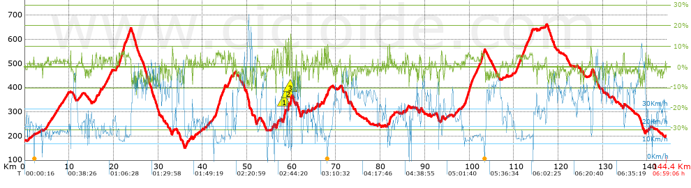
Distance in Km: 144.44
Climb in m: 2105
IBP: 151 BYC

Santi Dongil Diaz
926 published routes

Add to my Group or Club

 Height in m      Climb in %      Speed in Km/h      Speed < 2 Km/h

Climbs > 5%

Climbs >5% Climbs >10% Climbs >15% Climbs >20% Climbs >25%
 Steep slope of 111 m.   Average slope  Distances  Download as waypoint
1
 Km 12.781  6%  111 m
 Steep slope of 252 m.  Average slope  Distances  Download as waypoint
2
 Km 15.944  6%  252 m
 Steep slope of 153 m.  Average slope  Distances  Download as waypoint
3
 Km 16.953  5%  153 m
 Steep slope of 163 m.  Average slope  Distances  Download as waypoint
4
 Km 18.947  6%  163 m
 Steep slope of 192 m.  Average slope  Distances  Download as waypoint
5
 Km 20.575  5%  192 m
 Steep slope of 1371 m.  Average slope  Distances  Download as waypoint
6
 Km 21.205  7%  1371 m
 Steep slope of 265 m.  Average slope  Distances  Download as waypoint
7
 Km 23.023  5%  265 m
 Steep slope of 318 m.  Average slope  Distances  Download as waypoint
8
 Km 23.446  6%  318 m
 Steep slope of 172 m.  Average slope  Distances  Download as waypoint
9
 Km 33.2  7%  172 m
 Steep slope of 116 m.  Average slope  Distances  Download as waypoint
10
 Km 36.426  5%  116 m
 Steep slope of 103 m.  Average slope  Distances  Download as waypoint
11
 Km 38.266  6%  103 m
 Steep slope of 1245 m.  Average slope  Distances  Download as waypoint
12
 Km 42.961  7%  1245 m
 Steep slope of 144 m.  Average slope  Distances  Download as waypoint
13
 Km 44.404  6%  144 m
 Steep slope of 104 m.  Average slope  Distances  Download as waypoint
14
 Km 44.655  6%  104 m
 Steep slope of 209 m.  Average slope  Distances  Download as waypoint
15
 Km 44.873  7%  209 m
 Steep slope of 444 m.  Average slope  Distances  Download as waypoint
16
 Km 45.849  6%  444 m
 Steep slope of 110 m.  Average slope  Distances  Download as waypoint
17
 Km 46.958  8%  110 m
 Steep slope of 110 m.  Average slope  Distances  Download as waypoint
18
 Km 52.253  8%  110 m
 Steep slope of 104 m.  Average slope  Distances  Download as waypoint
19
 Km 55.672  8%  104 m
 Steep slope of 297 m.  Average slope  Distances  Download as waypoint
20
 Km 56.67  8%  297 m
 Steep slope of 520 m.  Average slope  Distances  Download as waypoint
21
 Km 58.149  8%  185 m
22
 Km 58.333  11%  111 m
23
 Km 58.445  7%  224 m
 Steep slope of 228 m.  Average slope  Distances  Download as waypoint
24
 Km 59.273  13%  151 m
25
 Km 59.424  8%  77 m
 Steep slope of 171 m.  Average slope  Distances  Download as waypoint
26
 Km 59.798  14%  171 m
 Steep slope of 256 m.  Average slope  Distances  Download as waypoint
27
 Km 62.294  6%  256 m
 Steep slope of 140 m.  Average slope  Distances  Download as waypoint
28
 Km 67.272  9%  140 m
 Steep slope of 106 m.  Average slope  Distances  Download as waypoint
29
 Km 67.549  8%  106 m
 Steep slope of 108 m.  Average slope  Distances  Download as waypoint
30
 Km 67.806  8%  108 m
 Steep slope of 203 m.  Average slope  Distances  Download as waypoint
31
 Km 68.1  8%  203 m
 Steep slope of 103 m.  Average slope  Distances  Download as waypoint
32
 Km 81.56  9%  103 m
 Steep slope of 322 m.  Average slope  Distances  Download as waypoint
33
 Km 81.99  7%  322 m
 Steep slope of 130 m.  Average slope  Distances  Download as waypoint
34
 Km 85.995  6%  130 m
 Steep slope of 113 m.  Average slope  Distances  Download as waypoint
35
 Km 88.781  6%  113 m
 Steep slope of 202 m.  Average slope  Distances  Download as waypoint
36
 Km 93.738  8%  202 m
 Steep slope of 527 m.  Average slope  Distances  Download as waypoint
37
 Km 99.09  6%  527 m
 Steep slope of 340 m.  Average slope  Distances  Download as waypoint
38
 Km 99.718  6%  340 m
 Steep slope of 241 m.  Average slope  Distances  Download as waypoint
39
 Km 100.24  6%  241 m
 Steep slope of 112 m.  Average slope  Distances  Download as waypoint
40
 Km 100.847  5%  112 m
 Steep slope of 385 m.  Average slope  Distances  Download as waypoint
41
 Km 102.602  6%  385 m
 Steep slope of 312 m.  Average slope  Distances  Download as waypoint
42
 Km 103.098  6%  312 m
 Steep slope of 146 m.  Average slope  Distances  Download as waypoint
43
 Km 110.565  5%  146 m
 Steep slope of 109 m.  Average slope  Distances  Download as waypoint
44
 Km 111.216  6%  109 m
 Steep slope of 202 m.  Average slope  Distances  Download as waypoint
45
 Km 111.47  5%  202 m
 Steep slope of 324 m.  Average slope  Distances  Download as waypoint
46
 Km 111.956  5%  324 m
 Steep slope of 183 m.  Average slope  Distances  Download as waypoint
47
 Km 112.455  5%  183 m
 Steep slope of 190 m.  Average slope  Distances  Download as waypoint
48
 Km 113.715  5%  190 m
 Steep slope of 201 m.  Average slope  Distances  Download as waypoint
49
 Km 114.025  6%  201 m
 Steep slope of 356 m.  Average slope  Distances  Download as waypoint
50
 Km 127.293  6%  356 m
 Steep slope of 208 m.  Average slope  Distances  Download as waypoint
51
 Km 134.648  8%  208 m
 Steep slope of 151 m.  Average slope  Distances  Download as waypoint
52
 Km 139.623  6%  151 m


Description of the route


Presence of ramps


 Climbs  Distance  % of the total  Speed  Your speed would be  Time  Your time would be
   15 - 30%  0.108  0.07  7.78  ?  0:00:50  ?
   10 - 15%  0.903  0.63  9.1  ?  0:05:57  ?
   5 - 10%  14.337  9.93  14.28  ?  1:00:15  ?
   1 - 5%  38.311  26.52  19.03  ?  2:00:46  ?
   Total*  53.659 Km  37.15 %  17.14 Km/h  ? Km/h    3:07:48 h  ? h  
 Flat
   1 - -1%  38.902 Km  26.93 %  28.01 Km/h  ? Km/h    1:23:20 h  ? h  
 Descents
   -1 - -5%  36.142  25.02  35.64  ?  1:00:51  ?
   -5 - -10%  14.254  9.87  43.75  ?  0:19:33  ?
   -10 - -15%  1.375  0.95  40.9  ?  0:02:01  ?
   -15 - -30%  0.111  0.08  49.77  ?  0:00:08  ?
   Total*  51.881 Km  35.92 %  37.71 Km/h  ? Km/h    1:22:33 h  ? h  
* The total has not necessarily coincide with the sum of the partials after correction of errors

How long would it take you?

How long would it take you to cover this route?
There are routes without a valid time information, but with your average stats you can assess the possible duration

Santi Dongil Diaz to cover this route you've need a time of:   5:53:41 h 
If you sign in and have a minimum of two tracks of this same modality, you can know your time for this route, calculated from your stats..


¿Cuanto consumirá tu E-BIKE?

Entra tu E-IBP (formato n,nn)

E-IBP :   X 151 = 


 Detected activity type =  ()
 Penalization due to track conditions: 41 %   ( > 50 % = MTB, < 50 % = RDB)
 Reliability of the track: A   (2103/77/0/-/-/77)
 Correction level applied to the track: 0
DIFFICULTY OF THE ROUTE
IBP = 151 BYC
According to your statistics
 Your time in motion would be: ? h
Your average speed would be: ? Km/h
 

 Total Distance: 144.44 Km
 Analysed distance: 144.44 Km
 Linear distance: 0.02 Km

 Cumulated positive ramps: 2104.57 m  list of points info
 Cumulated negative ramps: 2087.37 m
 Maximum height: 660.8 m
 Minimum height: 151.6 m
 Climbing Ratio: 3.92 %
 Descent ratio: 4.02 %
 Cumulated postive ramps per Km: 14.57 m
 Cumulated negative ramps per Km: 14.45 m

 Total time: 6:59:06 h
 Time in movement: 5:53:41 h
 According to your statistics
 Your time in motion would be: ? h  
 Stopped time: 1:05:25 h
 Maximum slope filter: ~30 %
 Minimum separation analysed: ~30 m
 Number of points: 10898   (cad. 13.25 m)
 Significant waypoints: 4016   (cad. 35.97 m / 36.85 %)

 Changes in direction per Km: 9.57
 Changes in direction > 5º por Km: 4.72
 Cumulated straight stretches: 55.972 Km
 Straight stretches per Km: 387.51 m
 Penalized slope changes: 22
 Penalized slope changes per Km: 0.152

 Average speed in total: 20.68 Km/h
 Average speed while moving: 24.5 Km/h
 According to your statistics
 Your average speed would be: ? Km/h  
 Maximum sustained speed: 78.33 Km/h


Comments

You can be the first one in commenting this route

 
My comments
:
Add comment  (Registered users)
 
Notify me answers to my comment  Do not notify answers to my comment


Share this route with a friend

Your friend will receive a message with a link to this page:
will see your email and your user name if you do it as registered user.


Write here your name (optional)

E-mail address of your friend(s). You can include various addresses separated by commas

Text or comment (optional) maximum 255 characters long, 255 Available characters

As a non registered users you need to fill-in the captcha text.
  Change image
Type the image characters.
 
 Share with a friend


Visited history

Delete history

Marked routes for review later or compare

My favorites


  Notify anomaly in this route Share in Facebook