Giro mattutino

MTB
MTB
Ref..: 1092978
Published: 19/03/2023
Performed: 18/03/2023
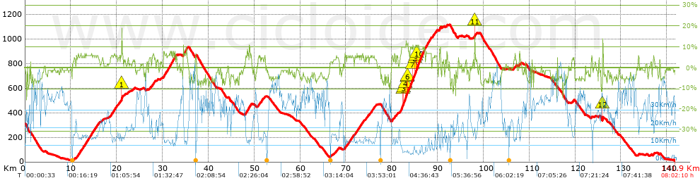
Distance in Km: 141.9
Climb in m: 2684
IBP: 183 BYC


 Height in m      Climb in %      Speed in Km/h      Speed < 2 Km/h

Climbs > 5%

Climbs >5% Climbs >10% Climbs >15% Climbs >20% Climbs >25%
 Steep slope of 102 m.   Average slope  Distances  Download as waypoint
1
 Km 11.237  6%  102 m
 Steep slope of 998 m.  Average slope  Distances  Download as waypoint
2
 Km 11.437  6%  998 m
 Steep slope of 3589 m.  Average slope  Distances  Download as waypoint
3
 Km 12.538  6%  3589 m
 Steep slope of 1303 m.  Average slope  Distances  Download as waypoint
4
 Km 18.736  6%  1303 m
 Steep slope of 265 m.  Average slope  Distances  Download as waypoint
5
 Km 20.376  5%  265 m
 Steep slope of 569 m.  Average slope  Distances  Download as waypoint
6
 Km 20.828  6%  261 m
7
 Km 21.089  16%  110 m
8
 Km 21.2  7%  198 m
 Steep slope of 92 m.  Average slope  Distances  Download as waypoint
9
 Km 27.265  5%  92 m
 Steep slope of 615 m.  Average slope  Distances  Download as waypoint
10
 Km 27.702  6%  615 m
 Steep slope of 2504 m.  Average slope  Distances  Download as waypoint
11
 Km 30.219  7%  2504 m
 Steep slope of 146 m.  Average slope  Distances  Download as waypoint
12
 Km 32.973  6%  146 m
 Steep slope of 978 m.  Average slope  Distances  Download as waypoint
13
 Km 34.511  7%  978 m
 Steep slope of 678 m.  Average slope  Distances  Download as waypoint
14
 Km 48.099  6%  678 m
 Steep slope of 148 m.  Average slope  Distances  Download as waypoint
15
 Km 48.88  6%  148 m
 Steep slope of 256 m.  Average slope  Distances  Download as waypoint
16
 Km 49.136  6%  256 m
 Steep slope of 377 m.  Average slope  Distances  Download as waypoint
17
 Km 50.951  5%  377 m
 Steep slope of 359 m.  Average slope  Distances  Download as waypoint
18
 Km 51.554  6%  359 m
 Steep slope of 254 m.  Average slope  Distances  Download as waypoint
19
 Km 67.949  5%  254 m
 Steep slope of 278 m.  Average slope  Distances  Download as waypoint
20
 Km 69.792  6%  278 m
 Steep slope of 707 m.  Average slope  Distances  Download as waypoint
21
 Km 70.214  6%  707 m
 Steep slope of 566 m.  Average slope  Distances  Download as waypoint
22
 Km 71.02  6%  566 m
 Steep slope of 506 m.  Average slope  Distances  Download as waypoint
23
 Km 71.948  6%  506 m
 Steep slope of 548 m.  Average slope  Distances  Download as waypoint
24
 Km 72.552  6%  548 m
 Steep slope of 131 m.  Average slope  Distances  Download as waypoint
25
 Km 73.236  6%  131 m
 Steep slope of 473 m.  Average slope  Distances  Download as waypoint
26
 Km 73.476  6%  473 m
 Steep slope of 138 m.  Average slope  Distances  Download as waypoint
27
 Km 74.287  5%  138 m
 Steep slope of 252 m.  Average slope  Distances  Download as waypoint
28
 Km 74.683  6%  252 m
 Steep slope of 171 m.  Average slope  Distances  Download as waypoint
29
 Km 75.255  5%  171 m
 Steep slope of 631 m.  Average slope  Distances  Download as waypoint
30
 Km 75.56  6%  631 m
 Steep slope of 285 m.  Average slope  Distances  Download as waypoint
31
 Km 80.061  6%  285 m
 Steep slope of 209 m.  Average slope  Distances  Download as waypoint
32
 Km 80.606  6%  209 m
 Steep slope of 297 m.  Average slope  Distances  Download as waypoint
33
 Km 81  5%  297 m
 Steep slope of 5394 m.  Average slope  Distances  Download as waypoint
34
 Km 81.9  9%  545 m
35
 Km 82.445  10%  163 m
36
 Km 82.607  10%  364 m
37
 Km 82.972  11%  434 m
38
 Km 83.406  11%  98 m
39
 Km 83.504  11%  102 m
40
 Km 83.606  9%  1001 m
41
 Km 84.607  11%  91 m
42
 Km 84.699  9%  341 m
43
 Km 85.04  10%  258 m
44
 Km 85.298  10%  136 m
45
 Km 85.434  10%  577 m
46
 Km 86.012  9%  1284 m
 Steep slope of 1248 m.  Average slope  Distances  Download as waypoint
47
 Km 87.43  7%  1248 m
 Steep slope of 988 m.  Average slope  Distances  Download as waypoint
48
 Km 88.922  5%  988 m
 Steep slope of 347 m.  Average slope  Distances  Download as waypoint
49
 Km 90.353  8%  347 m
 Steep slope of 134 m.  Average slope  Distances  Download as waypoint
50
 Km 92.02  8%  134 m
 Steep slope of 140 m.  Average slope  Distances  Download as waypoint
51
 Km 98.094  16%  105 m
52
 Km 98.199  10%  35 m
 Steep slope of 112 m.  Average slope  Distances  Download as waypoint
53
 Km 106.602  5%  112 m
 Steep slope of 181 m.  Average slope  Distances  Download as waypoint
54
 Km 107.83  6%  181 m
 Steep slope of 131 m.  Average slope  Distances  Download as waypoint
55
 Km 123.583  6%  131 m
 Steep slope of 197 m.  Average slope  Distances  Download as waypoint
56
 Km 125.979  14%  166 m
57
 Km 126.145  10%  31 m
 Steep slope of 134 m.  Average slope  Distances  Download as waypoint
58
 Km 133.829  6%  134 m
 Steep slope of 161 m.  Average slope  Distances  Download as waypoint
59
 Km 137.105  5%  161 m


Description of the route


Presence of ramps


 Climbs  Distance  % of the total  Speed  Your speed would be  Time  Your time would be
   15 - 30%  0.179  0.13  13.13  ?  0:00:49  ?
   10 - 15%  2.436  1.72  8.21  ?  0:17:48  ?
   5 - 10%  25.727  18.13  12.67  ?  2:01:52  ?
   1 - 5%  24.452  17.23  17.94  ?  1:21:48  ?
   Total*  52.794 Km  37.2 %  14.25 Km/h  ? Km/h    3:42:17 h  ? h  
 Flat
   1 - -1%  22.145 Km  15.61 %  26.71 Km/h  ? Km/h    0:49:45 h  ? h  
 Descents
   -1 - -5%  40.009  28.19  32.65  ?  1:13:31  ?
   -5 - -10%  26.092  18.39  35.33  ?  0:44:19  ?
   -10 - -15%  0.754  0.53  26.36  ?  0:01:43  ?
   -15 - -30%  0.108  0.08  27.83  ?  0:00:14  ?
   Total*  66.964 Km  47.19 %  33.54 Km/h  ? Km/h    1:59:47 h  ? h  
* The total has not necessarily coincide with the sum of the partials after correction of errors

How long would it take you?

How long would it take you to cover this route?
There are routes without a valid time information, but with your average stats you can assess the possible duration

Massimiliano_Figliuzzi to cover this route you've need a time of:   6:31:49 h 
If you sign in and have a minimum of two tracks of this same modality, you can know your time for this route, calculated from your stats..


¿Cuanto consumirá tu E-BIKE?

Entra tu E-IBP (formato n,nn)

E-IBP :   X 183 = 


 Detected activity type =  ()
 Penalization due to track conditions: 57 %   ( > 50 % = MTB, < 50 % = RDB)
 Reliability of the track: A   (2683/86/0/-/-/86)
 Correction level applied to the track: 0
DIFFICULTY OF THE ROUTE
IBP = 183 BYC
According to your statistics
 Your time in motion would be: ? h
Your average speed would be: ? Km/h
 

 Total Distance: 141.9 Km
 Analysed distance: 141.9 Km
 Linear distance: 5.74 Km

 Cumulated positive ramps: 2683.6 m  list of points info
 Cumulated negative ramps: 2951.3 m
 Maximum height: 1117.2 m
 Minimum height: 9.5 m
 Climbing Ratio: 5.08 %
 Descent ratio: 4.41 %
 Cumulated postive ramps per Km: 18.91 m
 Cumulated negative ramps per Km: 20.8 m

 Total time: 8:02:10 h
 Time in movement: 6:31:49 h
 According to your statistics
 Your time in motion would be: ? h  
 Stopped time: 1:30:21 h
 Maximum slope filter: ~30 %
 Minimum separation analysed: ~30 m
 Number of points: 10835   (cad. 13.1 m)
 Significant waypoints: 4005   (cad. 35.43 m / 36.96 %)

 Changes in direction per Km: 9.42
 Changes in direction > 5º por Km: 6.36
 Cumulated straight stretches: 31.678 Km
 Straight stretches per Km: 223.24 m
 Penalized slope changes: 22
 Penalized slope changes per Km: 0.155

 Average speed in total: 17.66 Km/h
 Average speed while moving: 21.73 Km/h
 According to your statistics
 Your average speed would be: ? Km/h  
 Maximum sustained speed: 60.52 Km/h


Comments

You can be the first one in commenting this route

 
My comments
:
Add comment  (Registered users)
 
Notify me answers to my comment  Do not notify answers to my comment


Share this route with a friend

Your friend will receive a message with a link to this page:
will see your email and your user name if you do it as registered user.


Write here your name (optional)

E-mail address of your friend(s). You can include various addresses separated by commas

Text or comment (optional) maximum 255 characters long, 255 Available characters

As a non registered users you need to fill-in the captcha text.
  Change image
Type the image characters.
 
 Share with a friend


Visited history

Delete history

Marked routes for review later or compare

My favorites


  Notify anomaly in this route Share in Facebook