O Galleiro pola brava !

MTB
MTB
Ref..: 1078216
Published: 13/11/2022
Performed: 13/11/2022
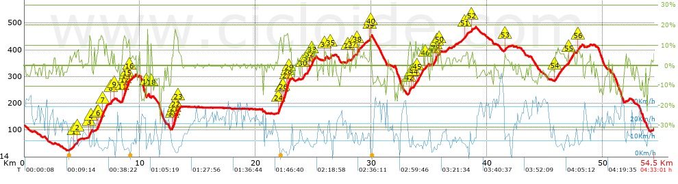
Distance in Km: 54.52
Climb in m: 1287
IBP: 94 BYC

Near ...
Acevedo (Ponte Sampaio), Aranza (Soutomaior), Arcade (Santiago), Bretoña (Curro), Calle, A (Arcade), Canicouva, A (Santo Estevo)
Javier Durán
299 published routes

Add to my Group or Club

 Height in m      Climb in %      Speed in Km/h      Speed < 2 Km/h

Climbs > 5%

Climbs >5% Climbs >10% Climbs >15% Climbs >20% Climbs >25%
 Steep slope of 101 m.   Average slope  Distances  Download as waypoint
1
 Km 4.305  7%  101 m
 Steep slope of 135 m.  Average slope  Distances  Download as waypoint
2
 Km 4.545  9%  135 m
 Steep slope of 232 m.  Average slope  Distances  Download as waypoint
3
 Km 5.61  11%  133 m
4
 Km 5.742  11%  99 m
 Steep slope of 860 m.  Average slope  Distances  Download as waypoint
5
 Km 6.237  5%  138 m
6
 Km 6.375  12%  429 m
7
 Km 6.804  10%  293 m
 Steep slope of 106 m.  Average slope  Distances  Download as waypoint
8
 Km 7.505  9%  106 m
 Steep slope of 98 m.  Average slope  Distances  Download as waypoint
9
 Km 7.716  6%  98 m
 Steep slope of 657 m.  Average slope  Distances  Download as waypoint
10
 Km 8.462  9%  35 m
11
 Km 8.497  12%  138 m
12
 Km 8.635  16%  98 m
13
 Km 8.733  13%  67 m
14
 Km 8.8  10%  101 m
15
 Km 8.901  13%  167 m
16
 Km 9.068  5%  51 m
 Steep slope of 112 m.  Average slope  Distances  Download as waypoint
17
 Km 10.603  15%  112 m
 Steep slope of 136 m.  Average slope  Distances  Download as waypoint
18
 Km 10.942  7%  136 m
 Steep slope of 774 m.  Average slope  Distances  Download as waypoint
19
 Km 12.754  8%  159 m
20
 Km 12.913  14%  66 m
21
 Km 12.979  17%  127 m
22
 Km 13.106  13%  192 m
23
 Km 13.298  6%  230 m
 Steep slope of 1124 m.  Average slope  Distances  Download as waypoint
24
 Km 21.96  12%  263 m
25
 Km 22.223  7%  165 m
26
 Km 22.387  14%  233 m
27
 Km 22.621  15%  173 m
28
 Km 22.794  14%  65 m
29
 Km 22.858  7%  225 m
 Steep slope of 277 m.  Average slope  Distances  Download as waypoint
30
 Km 24.051  6%  277 m
 Steep slope of 577 m.  Average slope  Distances  Download as waypoint
31
 Km 24.466  7%  249 m
32
 Km 24.715  10%  136 m
33
 Km 24.851  10%  192 m
 Steep slope of 201 m.  Average slope  Distances  Download as waypoint
34
 Km 25.934  7%  201 m
 Steep slope of 201 m.  Average slope  Distances  Download as waypoint
35
 Km 26.44  7%  201 m
 Steep slope of 104 m.  Average slope  Distances  Download as waypoint
36
 Km 27.933  7%  104 m
 Steep slope of 213 m.  Average slope  Distances  Download as waypoint
37
 Km 28.373  7%  213 m
 Steep slope of 236 m.  Average slope  Distances  Download as waypoint
38
 Km 28.766  8%  236 m
 Steep slope of 159 m.  Average slope  Distances  Download as waypoint
39
 Km 29.864  13%  127 m
40
 Km 29.991  7%  32 m
 Steep slope of 232 m.  Average slope  Distances  Download as waypoint
41
 Km 33.244  9%  69 m
42
 Km 33.313  11%  131 m
43
 Km 33.444  9%  32 m
 Steep slope of 206 m.  Average slope  Distances  Download as waypoint
44
 Km 33.619  6%  206 m
 Steep slope of 554 m.  Average slope  Distances  Download as waypoint
45
 Km 33.92  8%  554 m
 Steep slope of 238 m.  Average slope  Distances  Download as waypoint
46
 Km 34.646  6%  238 m
 Steep slope of 417 m.  Average slope  Distances  Download as waypoint
47
 Km 35.329  8%  256 m
48
 Km 35.585  12%  130 m
49
 Km 35.714  7%  31 m
 Steep slope of 167 m.  Average slope  Distances  Download as waypoint
50
 Km 35.846  7%  167 m
 Steep slope of 292 m.  Average slope  Distances  Download as waypoint
51
 Km 38.074  6%  292 m
 Steep slope of 100 m.  Average slope  Distances  Download as waypoint
52
 Km 38.716  7%  100 m
 Steep slope of 102 m.  Average slope  Distances  Download as waypoint
53
 Km 41.537  6%  102 m
 Steep slope of 840 m.  Average slope  Distances  Download as waypoint
54
 Km 45.905  6%  840 m
 Steep slope of 541 m.  Average slope  Distances  Download as waypoint
55
 Km 47.024  7%  541 m
 Steep slope of 344 m.  Average slope  Distances  Download as waypoint
56
 Km 47.846  6%  344 m


Description of the route


Presence of ramps


 Climbs  Distance  % of the total  Speed  Your speed would be  Time  Your time would be
   15 - 30%  0.598  1.1  4.5  ?  0:07:58  ?
   10 - 15%  2.638  4.84  6.54  ?  0:24:12  ?
   5 - 10%  8.093  14.85  8.88  ?  0:54:42  ?
   1 - 5%  9.662  17.72  12.64  ?  0:45:52  ?
   Total*  20.992 Km  38.51 %  9.49 Km/h  ? Km/h    2:12:44 h  ? h  
 Flat
   1 - -1%  12.026 Km  22.06 %  18.49 Km/h  ? Km/h    0:39:02 h  ? h  
 Descents
   -1 - -5%  10.426  19.12  20.19  ?  0:30:59  ?
   -5 - -10%  7.545  13.84  19.68  ?  0:23:00  ?
   -10 - -15%  2.568  4.71  20.59  ?  0:07:29  ?
   -15 - -30%  0.959  1.76  15.41  ?  0:03:44  ?
   Total*  21.499 Km  39.43 %  19.78 Km/h  ? Km/h    1:05:12 h  ? h  
* The total has not necessarily coincide with the sum of the partials after correction of errors

How long would it take you?

How long would it take you to cover this route?
There are routes without a valid time information, but with your average stats you can assess the possible duration

Javier Durán to cover this route you've need a time of:   3:56:58 h 
If you sign in and have a minimum of two tracks of this same modality, you can know your time for this route, calculated from your stats..


¿Cuanto consumirá tu E-BIKE?

Entra tu E-IBP (formato n,nn)

E-IBP :   X 94 = 


 Detected activity type =  ()
 Penalization due to track conditions: 63 %   ( > 50 % = MTB, < 50 % = RDB)
 Reliability of the track: B   (1288/67/0/-/-/67)
 Correction level applied to the track: 0
DIFFICULTY OF THE ROUTE
IBP = 94 BYC
According to your statistics
 Your time in motion would be: ? h
Your average speed would be: ? Km/h
 

 Total Distance: 54.52 Km
 Analysed distance: 54.52 Km
 Linear distance: 0.92 Km

 Cumulated positive ramps: 1286.96 m  list of points info
 Cumulated negative ramps: 1301.66 m
 Maximum height: 484.9 m
 Minimum height: 23.6 m
 Climbing Ratio: 6.13 %
 Descent ratio: 6.05 %
 Cumulated postive ramps per Km: 23.61 m
 Cumulated negative ramps per Km: 23.87 m

 Total time: 4:33:01 h
 Time in movement: 3:56:58 h
 According to your statistics
 Your time in motion would be: ? h  
 Stopped time: 0:36:03 h
 Maximum slope filter: ~30 %
 Minimum separation analysed: ~30 m
 Number of points: 4284   (cad. 12.73 m)
 Significant waypoints: 1538   (cad. 35.45 m / 35.9 %)

 Changes in direction per Km: 11.08
 Changes in direction > 5º por Km: 8.03
 Cumulated straight stretches: 8.769 Km
 Straight stretches per Km: 160.84 m
 Penalized slope changes: 13
 Penalized slope changes per Km: 0.238

 Average speed in total: 11.98 Km/h
 Average speed while moving: 13.8 Km/h
 According to your statistics
 Your average speed would be: ? Km/h  
 Maximum sustained speed: 52.44 Km/h


Comments

You can be the first one in commenting this route

 
My comments
:
Add comment  (Registered users)
 
Notify me answers to my comment  Do not notify answers to my comment


Share this route with a friend

Your friend will receive a message with a link to this page:
will see your email and your user name if you do it as registered user.


Write here your name (optional)

E-mail address of your friend(s). You can include various addresses separated by commas

Text or comment (optional) maximum 255 characters long, 255 Available characters

As a non registered users you need to fill-in the captcha text.
  Change image
Type the image characters.
 
 Share with a friend


Visited history

Delete history

Marked routes for review later or compare

My favorites


  Notify anomaly in this route Share in Facebook