Karakate

MTB
MTB
Ref..: 1078187
Published: 13/11/2022
Performed: 13/11/2022
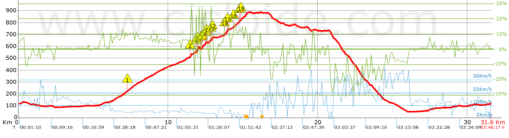
Distance in Km: 31.63
Climb in m: 1051
IBP: 92 BYC


 Height in m      Climb in %      Speed in Km/h      Speed < 2 Km/h

Climbs > 5%

Climbs >5% Climbs >10% Climbs >15% Climbs >20% Climbs >25%
 Steep slope of 238 m.   Average slope  Distances  Download as waypoint
1
 Km 0.07  5%  238 m
 Steep slope of 244 m.  Average slope  Distances  Download as waypoint
2
 Km 5.434  7%  244 m
 Steep slope of 2766 m.  Average slope  Distances  Download as waypoint
3
 Km 6.089  8%  1223 m
4
 Km 7.312  11%  197 m
5
 Km 7.509  8%  1346 m
 Steep slope of 332 m.  Average slope  Distances  Download as waypoint
6
 Km 8.983  8%  332 m
 Steep slope of 621 m.  Average slope  Distances  Download as waypoint
7
 Km 9.411  6%  621 m
 Steep slope of 257 m.  Average slope  Distances  Download as waypoint
8
 Km 10.465  7%  257 m
 Steep slope of 1119 m.  Average slope  Distances  Download as waypoint
9
 Km 10.922  7%  555 m
10
 Km 11.477  23%  101 m
11
 Km 11.578  5%  261 m
12
 Km 11.838  22%  35 m
13
 Km 11.873  17%  134 m
14
 Km 12.007  28%  33 m
 Steep slope of 134 m.  Average slope  Distances  Download as waypoint
15
 Km 12.207  20%  33 m
16
 Km 12.24  28%  101 m
 Steep slope of 129 m.  Average slope  Distances  Download as waypoint
17
 Km 12.438  27%  98 m
18
 Km 12.536  14%  31 m
 Steep slope of 300 m.  Average slope  Distances  Download as waypoint
19
 Km 12.665  9%  168 m
20
 Km 12.833  28%  33 m
21
 Km 12.866  27%  67 m
22
 Km 12.933  13%  32 m
 Steep slope of 335 m.  Average slope  Distances  Download as waypoint
23
 Km 13.739  15%  33 m
24
 Km 13.772  17%  204 m
25
 Km 13.976  15%  98 m
 Steep slope of 1098 m.  Average slope  Distances  Download as waypoint
26
 Km 14.204  7%  134 m
27
 Km 14.338  12%  413 m
28
 Km 14.751  11%  91 m
29
 Km 14.843  14%  355 m
30
 Km 15.198  14%  105 m
 Steep slope of 97 m.  Average slope  Distances  Download as waypoint
31
 Km 15.396  8%  97 m
 Steep slope of 96 m.  Average slope  Distances  Download as waypoint
32
 Km 18.253  6%  96 m
 Steep slope of 172 m.  Average slope  Distances  Download as waypoint
33
 Km 19.597  7%  172 m
 Steep slope of 96 m.  Average slope  Distances  Download as waypoint
34
 Km 27.743  6%  96 m
 Steep slope of 128 m.  Average slope  Distances  Download as waypoint
35
 Km 28.903  6%  128 m
 Steep slope of 104 m.  Average slope  Distances  Download as waypoint
36
 Km 29.203  6%  104 m


Description of the route


Presence of ramps


 Climbs  Distance  % of the total  Speed  Your speed would be  Time  Your time would be
   15 - 30%  1.168  3.69  5.45  ?  0:12:52  ?
   10 - 15%  1.69  5.34  4.84  ?  0:20:58  ?
   5 - 10%  6.058  19.15  6.93  ?  0:52:26  ?
   1 - 5%  5.298  16.75  9.72  ?  0:32:42  ?
   Total*  14.215 Km  44.94 %  7.17 Km/h  ? Km/h    1:58:58 h  ? h  
 Flat
   1 - -1%  6.378 Km  20.17 %  13.5 Km/h  ? Km/h    0:28:21 h  ? h  
 Descents
   -1 - -5%  3.469  10.97  14.75  ?  0:14:07  ?
   -5 - -10%  3.546  11.21  15.21  ?  0:13:59  ?
   -10 - -15%  1.265  4  20.15  ?  0:03:46  ?
   -15 - -30%  2.758  8.72  15.54  ?  0:10:39  ?
   Total*  11.038 Km  34.9 %  15.58 Km/h  ? Km/h    0:42:31 h  ? h  
* The total has not necessarily coincide with the sum of the partials after correction of errors

How long would it take you?

How long would it take you to cover this route?
There are routes without a valid time information, but with your average stats you can assess the possible duration

Iker_Barbarrubio_Cortijo to cover this route you've need a time of:   3:09:50 h 
If you sign in and have a minimum of two tracks of this same modality, you can know your time for this route, calculated from your stats..


¿Cuanto consumirá tu E-BIKE?

Entra tu E-IBP (formato n,nn)

E-IBP :   X 92 = 


 Detected activity type =  ()
 Penalization due to track conditions: 74 %   ( > 50 % = MTB, < 50 % = RDB)
 Reliability of the track: B   (1066/66/0/-/-/66)
 Correction level applied to the track: 0
DIFFICULTY OF THE ROUTE
IBP = 92 BYC
According to your statistics
 Your time in motion would be: ? h
Your average speed would be: ? Km/h
 

 Total Distance: 31.63 Km
 Analysed distance: 31.63 Km
 Linear distance: 0.08 Km

 Cumulated positive ramps: 1051.47 m  list of points info
 Cumulated negative ramps: 1061.24 m
 Maximum height: 891.1 m
 Minimum height: 49.1 m
 Climbing Ratio: 7.4 %
 Descent ratio: 9.61 %
 Cumulated postive ramps per Km: 33.24 m
 Cumulated negative ramps per Km: 33.55 m

 Total time: 3:48:17 h
 Time in movement: 3:09:50 h
 According to your statistics
 Your time in motion would be: ? h  
 Stopped time: 0:38:27 h
 Maximum slope filter: ~30 %
 Minimum separation analysed: ~30 m
 Number of points: 2644   (cad. 11.96 m)
 Significant waypoints: 908   (cad. 34.84 m / 34.34 %)

 Changes in direction per Km: 12.2
 Changes in direction > 5º por Km: 9.23
 Cumulated straight stretches: 4.599 Km
 Straight stretches per Km: 145.4 m
 Penalized slope changes: 5
 Penalized slope changes per Km: 0.158

 Average speed in total: 8.31 Km/h
 Average speed while moving: 10 Km/h
 According to your statistics
 Your average speed would be: ? Km/h  
 Maximum sustained speed: 41.93 Km/h


Comments

You can be the first one in commenting this route

 
My comments
:
Add comment  (Registered users)
 
Notify me answers to my comment  Do not notify answers to my comment


Share this route with a friend

Your friend will receive a message with a link to this page:
will see your email and your user name if you do it as registered user.


Write here your name (optional)

E-mail address of your friend(s). You can include various addresses separated by commas

Text or comment (optional) maximum 255 characters long, 255 Available characters

As a non registered users you need to fill-in the captcha text.
  Change image
Type the image characters.
 
 Share with a friend


Visited history

Delete history

Marked routes for review later or compare

My favorites


  Notify anomaly in this route Share in Facebook