2022 08 27 tocon collado del alguacil

MTB
MTB
Ref..: 1067245
Published: 29/08/2022
Performed: 27/08/2022
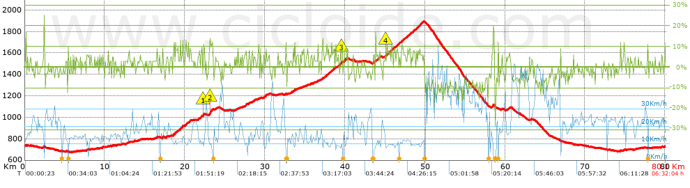
Distance in Km: 80.07
Climb in m: 1829
IBP: 134 BYC


 Height in m      Climb in %      Speed in Km/h      Speed < 2 Km/h

Climbs > 5%

Climbs >5% Climbs >10% Climbs >15% Climbs >20% Climbs >25%
 Steep slope of 107 m.   Average slope  Distances  Download as waypoint
1
 Km 7.679  5%  107 m
 Steep slope of 106 m.  Average slope  Distances  Download as waypoint
2
 Km 12.08  7%  106 m
 Steep slope of 140 m.  Average slope  Distances  Download as waypoint
3
 Km 12.913  6%  140 m
 Steep slope of 104 m.  Average slope  Distances  Download as waypoint
4
 Km 17.24  11%  104 m
 Steep slope of 101 m.  Average slope  Distances  Download as waypoint
5
 Km 17.664  8%  101 m
 Steep slope of 106 m.  Average slope  Distances  Download as waypoint
6
 Km 18.548  13%  106 m
 Steep slope of 170 m.  Average slope  Distances  Download as waypoint
7
 Km 18.769  8%  170 m
 Steep slope of 168 m.  Average slope  Distances  Download as waypoint
8
 Km 19.047  8%  168 m
 Steep slope of 372 m.  Average slope  Distances  Download as waypoint
9
 Km 19.375  9%  372 m
 Steep slope of 431 m.  Average slope  Distances  Download as waypoint
10
 Km 20.004  6%  431 m
 Steep slope of 165 m.  Average slope  Distances  Download as waypoint
11
 Km 20.568  8%  165 m
 Steep slope of 205 m.  Average slope  Distances  Download as waypoint
12
 Km 21.621  6%  205 m
 Steep slope of 423 m.  Average slope  Distances  Download as waypoint
13
 Km 21.963  5%  317 m
14
 Km 22.28  13%  106 m
 Steep slope of 523 m.  Average slope  Distances  Download as waypoint
15
 Km 22.99  8%  140 m
16
 Km 23.131  11%  182 m
17
 Km 23.312  10%  201 m
 Steep slope of 106 m.  Average slope  Distances  Download as waypoint
18
 Km 23.762  5%  106 m
 Steep slope of 281 m.  Average slope  Distances  Download as waypoint
19
 Km 27.441  9%  281 m
 Steep slope of 179 m.  Average slope  Distances  Download as waypoint
20
 Km 27.972  7%  179 m
 Steep slope of 111 m.  Average slope  Distances  Download as waypoint
21
 Km 28.329  5%  111 m
 Steep slope of 192 m.  Average slope  Distances  Download as waypoint
22
 Km 28.576  7%  192 m
 Steep slope of 331 m.  Average slope  Distances  Download as waypoint
23
 Km 29.823  8%  331 m
 Steep slope of 103 m.  Average slope  Distances  Download as waypoint
24
 Km 30.439  5%  103 m
 Steep slope of 145 m.  Average slope  Distances  Download as waypoint
25
 Km 33.166  7%  145 m
 Steep slope of 273 m.  Average slope  Distances  Download as waypoint
26
 Km 33.481  8%  273 m
 Steep slope of 110 m.  Average slope  Distances  Download as waypoint
27
 Km 33.933  5%  110 m
 Steep slope of 105 m.  Average slope  Distances  Download as waypoint
28
 Km 34.147  5%  105 m
 Steep slope of 108 m.  Average slope  Distances  Download as waypoint
29
 Km 34.58  6%  108 m
 Steep slope of 108 m.  Average slope  Distances  Download as waypoint
30
 Km 35.292  7%  108 m
 Steep slope of 108 m.  Average slope  Distances  Download as waypoint
31
 Km 35.84  6%  108 m
 Steep slope of 101 m.  Average slope  Distances  Download as waypoint
32
 Km 36.09  7%  101 m
 Steep slope of 108 m.  Average slope  Distances  Download as waypoint
33
 Km 36.641  6%  108 m
 Steep slope of 386 m.  Average slope  Distances  Download as waypoint
34
 Km 37.141  6%  386 m
 Steep slope of 416 m.  Average slope  Distances  Download as waypoint
35
 Km 37.629  7%  416 m
 Steep slope of 251 m.  Average slope  Distances  Download as waypoint
36
 Km 38.14  6%  251 m
 Steep slope of 324 m.  Average slope  Distances  Download as waypoint
37
 Km 38.492  7%  324 m
 Steep slope of 203 m.  Average slope  Distances  Download as waypoint
38
 Km 39.056  6%  203 m
 Steep slope of 351 m.  Average slope  Distances  Download as waypoint
39
 Km 39.361  11%  35 m
40
 Km 39.396  9%  140 m
41
 Km 39.536  10%  109 m
42
 Km 39.645  9%  67 m
 Steep slope of 316 m.  Average slope  Distances  Download as waypoint
43
 Km 39.895  8%  316 m
 Steep slope of 169 m.  Average slope  Distances  Download as waypoint
44
 Km 43.513  9%  169 m
 Steep slope of 382 m.  Average slope  Distances  Download as waypoint
45
 Km 43.781  11%  104 m
46
 Km 43.885  5%  278 m
 Steep slope of 179 m.  Average slope  Distances  Download as waypoint
47
 Km 44.261  6%  179 m
 Steep slope of 201 m.  Average slope  Distances  Download as waypoint
48
 Km 45.115  10%  135 m
49
 Km 45.251  9%  66 m
 Steep slope of 829 m.  Average slope  Distances  Download as waypoint
50
 Km 45.421  8%  257 m
51
 Km 45.678  8%  111 m
52
 Km 45.789  5%  109 m
53
 Km 45.898  6%  352 m
 Steep slope of 415 m.  Average slope  Distances  Download as waypoint
54
 Km 46.388  7%  415 m
 Steep slope of 652 m.  Average slope  Distances  Download as waypoint
55
 Km 46.914  6%  652 m
 Steep slope of 135 m.  Average slope  Distances  Download as waypoint
56
 Km 47.663  7%  135 m
 Steep slope of 443 m.  Average slope  Distances  Download as waypoint
57
 Km 47.899  7%  443 m
 Steep slope of 320 m.  Average slope  Distances  Download as waypoint
58
 Km 48.451  7%  320 m
 Steep slope of 763 m.  Average slope  Distances  Download as waypoint
59
 Km 48.875  8%  763 m
 Steep slope of 134 m.  Average slope  Distances  Download as waypoint
60
 Km 49.776  7%  134 m
 Steep slope of 240 m.  Average slope  Distances  Download as waypoint
61
 Km 58.381  6%  240 m
 Steep slope of 109 m.  Average slope  Distances  Download as waypoint
62
 Km 60.268  5%  109 m
 Steep slope of 108 m.  Average slope  Distances  Download as waypoint
63
 Km 60.527  6%  108 m
 Steep slope of 177 m.  Average slope  Distances  Download as waypoint
64
 Km 74.804  7%  177 m
 Steep slope of 106 m.  Average slope  Distances  Download as waypoint
65
 Km 79.492  5%  106 m


Description of the route


Presence of ramps


 Climbs  Distance  % of the total  Speed  Your speed would be  Time  Your time would be
   15 - 30%  0.489  0.61  6.24  ?  0:04:42  ?
   10 - 15%  3.378  4.22  11.75  ?  0:17:15  ?
   5 - 10%  13.438  16.78  12.66  ?  1:03:40  ?
   1 - 5%  15.007  18.74  16.2  ?  0:55:35  ?
   Total*  32.313 Km  40.35 %  13.73 Km/h  ? Km/h    2:21:12 h  ? h  
 Flat
   1 - -1%  17.198 Km  21.48 %  18.5 Km/h  ? Km/h    0:55:46 h  ? h  
 Descents
   -1 - -5%  14.207  17.74  21.6  ?  0:39:28  ?
   -5 - -10%  12.121  15.14  28.96  ?  0:25:07  ?
   -10 - -15%  3.49  4.36  27.74  ?  0:07:33  ?
   -15 - -30%  0.759  0.95  12.04  ?  0:03:47  ?
   Total*  30.577 Km  38.19 %  24.17 Km/h  ? Km/h    1:15:55 h  ? h  
* The total has not necessarily coincide with the sum of the partials after correction of errors

How long would it take you?

How long would it take you to cover this route?
There are routes without a valid time information, but with your average stats you can assess the possible duration

Armando_Rodriguez_Nieto to cover this route you've need a time of:   4:32:53 h 
If you sign in and have a minimum of two tracks of this same modality, you can know your time for this route, calculated from your stats..


¿Cuanto consumirá tu E-BIKE?

Entra tu E-IBP (formato n,nn)

E-IBP :   X 134 = 


 Detected activity type =  ()
 Penalization due to track conditions: 75 %   ( > 50 % = MTB, < 50 % = RDB)
 Reliability of the track: C   (1835/52/0/-/-/52)
 Correction level applied to the track: 0
DIFFICULTY OF THE ROUTE
IBP = 134 BYC
According to your statistics
 Your time in motion would be: ? h
Your average speed would be: ? Km/h
 

 Total Distance: 80.07 Km
 Analysed distance: 80.07 Km
 Linear distance: 0.02 Km

 Cumulated positive ramps: 1829.02 m  list of points info
 Cumulated negative ramps: 1831.18 m
 Maximum height: 1894 m
 Minimum height: 674 m
 Climbing Ratio: 5.66 %
 Descent ratio: 5.99 %
 Cumulated postive ramps per Km: 22.84 m
 Cumulated negative ramps per Km: 22.87 m

 Total time: 6:32:04 h
 Time in movement: 4:32:53 h
 According to your statistics
 Your time in motion would be: ? h  
 Stopped time: 1:59:11 h
 Maximum slope filter: ~30 %
 Minimum separation analysed: ~30 m
 Number of points: 6313   (cad. 12.68 m)
 Significant waypoints: 2215   (cad. 36.17 m / 35.09 %)

 Changes in direction per Km: 10.73
 Changes in direction > 5º por Km: 6.91
 Cumulated straight stretches: 18.06 Km
 Straight stretches per Km: 225.55 m
 Penalized slope changes: 11
 Penalized slope changes per Km: 0.137

 Average speed in total: 12.25 Km/h
 Average speed while moving: 17.61 Km/h
 According to your statistics
 Your average speed would be: ? Km/h  
 Maximum sustained speed: 62.09 Km/h


Comments

You can be the first one in commenting this route

 
My comments
:
Add comment  (Registered users)
 
Notify me answers to my comment  Do not notify answers to my comment


Share this route with a friend

Your friend will receive a message with a link to this page:
will see your email and your user name if you do it as registered user.


Write here your name (optional)

E-mail address of your friend(s). You can include various addresses separated by commas

Text or comment (optional) maximum 255 characters long, 255 Available characters

As a non registered users you need to fill-in the captcha text.
  Change image
Type the image characters.
 
 Share with a friend


Visited history

Delete history

Marked routes for review later or compare

My favorites


  Notify anomaly in this route Share in Facebook