Pedra Llarga-Pla de les Arenes-Norris

Road
Road
Ref..: 1061061
Published: 25/07/2022
Performed: 24/07/2022
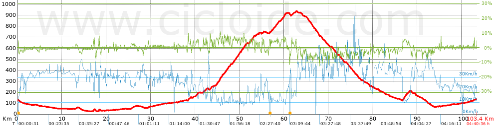
Distance in Km: 103.39
Climb in m: 1200
IBP: 86 BYC

Rally
Author: Rally
823 published routes

Add to my Group or Club

 Height in m      Climb in %      Speed in Km/h      Speed < 2 Km/h

Climbs > 5%

Climbs >5% Climbs >10% Climbs >15% Climbs >20% Climbs >25%
 Steep slope of 163 m.   Average slope  Distances  Download as waypoint
1
 Km 17.116  7%  163 m
 Steep slope of 119 m.  Average slope  Distances  Download as waypoint
2
 Km 18.268  10%  119 m
 Steep slope of 139 m.  Average slope  Distances  Download as waypoint
3
 Km 38.384  8%  139 m
 Steep slope of 148 m.  Average slope  Distances  Download as waypoint
4
 Km 40.543  6%  148 m
 Steep slope of 188 m.  Average slope  Distances  Download as waypoint
5
 Km 42.277  6%  188 m
 Steep slope of 128 m.  Average slope  Distances  Download as waypoint
6
 Km 43.339  8%  128 m
 Steep slope of 123 m.  Average slope  Distances  Download as waypoint
7
 Km 43.631  6%  123 m
 Steep slope of 370 m.  Average slope  Distances  Download as waypoint
8
 Km 44.832  6%  370 m
 Steep slope of 535 m.  Average slope  Distances  Download as waypoint
9
 Km 45.322  7%  535 m
 Steep slope of 284 m.  Average slope  Distances  Download as waypoint
10
 Km 45.973  6%  284 m
 Steep slope of 224 m.  Average slope  Distances  Download as waypoint
11
 Km 46.546  7%  224 m
 Steep slope of 350 m.  Average slope  Distances  Download as waypoint
12
 Km 46.899  6%  350 m
 Steep slope of 216 m.  Average slope  Distances  Download as waypoint
13
 Km 47.378  7%  216 m
 Steep slope of 250 m.  Average slope  Distances  Download as waypoint
14
 Km 47.767  7%  250 m
 Steep slope of 514 m.  Average slope  Distances  Download as waypoint
15
 Km 48.373  6%  514 m
 Steep slope of 1018 m.  Average slope  Distances  Download as waypoint
16
 Km 49.049  6%  1018 m
 Steep slope of 403 m.  Average slope  Distances  Download as waypoint
17
 Km 50.264  6%  403 m
 Steep slope of 382 m.  Average slope  Distances  Download as waypoint
18
 Km 50.802  7%  382 m
 Steep slope of 196 m.  Average slope  Distances  Download as waypoint
19
 Km 51.312  6%  196 m
 Steep slope of 194 m.  Average slope  Distances  Download as waypoint
20
 Km 52.174  6%  194 m
 Steep slope of 207 m.  Average slope  Distances  Download as waypoint
21
 Km 52.52  6%  207 m
 Steep slope of 398 m.  Average slope  Distances  Download as waypoint
22
 Km 52.914  6%  398 m
 Steep slope of 146 m.  Average slope  Distances  Download as waypoint
23
 Km 55.33  6%  146 m
 Steep slope of 136 m.  Average slope  Distances  Download as waypoint
24
 Km 56.678  6%  136 m
 Steep slope of 124 m.  Average slope  Distances  Download as waypoint
25
 Km 56.971  6%  124 m
 Steep slope of 113 m.  Average slope  Distances  Download as waypoint
26
 Km 57.244  6%  113 m
 Steep slope of 198 m.  Average slope  Distances  Download as waypoint
27
 Km 57.699  5%  198 m
 Steep slope of 226 m.  Average slope  Distances  Download as waypoint
28
 Km 58.055  5%  226 m
 Steep slope of 236 m.  Average slope  Distances  Download as waypoint
29
 Km 58.604  6%  236 m
 Steep slope of 148 m.  Average slope  Distances  Download as waypoint
30
 Km 59.272  5%  148 m
 Steep slope of 213 m.  Average slope  Distances  Download as waypoint
31
 Km 59.522  5%  213 m
 Steep slope of 494 m.  Average slope  Distances  Download as waypoint
32
 Km 59.864  6%  494 m
 Steep slope of 126 m.  Average slope  Distances  Download as waypoint
33
 Km 62.639  6%  126 m
 Steep slope of 269 m.  Average slope  Distances  Download as waypoint
34
 Km 86.694  5%  269 m
 Steep slope of 468 m.  Average slope  Distances  Download as waypoint
35
 Km 87.12  6%  468 m


Description of the route


Presence of ramps


 Climbs  Distance  % of the total  Speed  Your speed would be  Time  Your time would be
   15 - 30%  0  0  0  ?  0:00:00  ?
   10 - 15%  0.067  0.06  10.98  ?  0:00:22  ?
   5 - 10%  10.641  10.29  12.43  ?  0:51:21  ?
   1 - 5%  19.884  19.23  19.53  ?  1:01:05  ?
   Total*  30.593 Km  29.59 %  16.27 Km/h  ? Km/h    1:52:48 h  ? h  
 Flat
   1 - -1%  39.547 Km  38.25 %  29.83 Km/h  ? Km/h    1:19:33 h  ? h  
 Descents
   -1 - -5%  25.046  24.22  35.18  ?  0:42:43  ?
   -5 - -10%  7.922  7.66  40.63  ?  0:11:42  ?
   -10 - -15%  0.254  0.25  31.49  ?  0:00:29  ?
   -15 - -30%  0.029  0.03  26.33  ?  0:00:04  ?
   Total*  33.251 Km  32.16 %  36.3 Km/h  ? Km/h    0:54:58 h  ? h  
* The total has not necessarily coincide with the sum of the partials after correction of errors

How long would it take you?

How long would it take you to cover this route?
There are routes without a valid time information, but with your average stats you can assess the possible duration

Rally to cover this route you've need a time of:   4:07:19 h 
If you sign in and have a minimum of two tracks of this same modality, you can know your time for this route, calculated from your stats..


¿Cuanto consumirá tu E-BIKE?

Entra tu E-IBP (formato n,nn)

E-IBP :   X 86 = 


 Detected activity type =  ()
 Penalization due to track conditions: 33 %   ( > 50 % = MTB, < 50 % = RDB)
 Reliability of the track: A   (1200/78/0/-/-/78)
 Correction level applied to the track: 0
DIFFICULTY OF THE ROUTE
IBP = 86 BYC
According to your statistics
 Your time in motion would be: ? h
Your average speed would be: ? Km/h
 

 Total Distance: 103.39 Km
 Analysed distance: 103.39 Km
 Linear distance: 1.06 Km

 Cumulated positive ramps: 1200.4 m  list of points info
 Cumulated negative ramps: 1184.8 m
 Maximum height: 936.6 m
 Minimum height: 24.8 m
 Climbing Ratio: 3.92 %
 Descent ratio: 3.56 %
 Cumulated postive ramps per Km: 11.61 m
 Cumulated negative ramps per Km: 11.46 m

 Total time: 4:40:36 h
 Time in movement: 4:07:19 h
 According to your statistics
 Your time in motion would be: ? h  
 Stopped time: 0:33:17 h
 Maximum slope filter: ~30 %
 Minimum separation analysed: ~30 m
 Number of points: 3815   (cad. 27.1 m)
 Significant waypoints: 2194   (cad. 47.12 m / 57.51 %)

 Changes in direction per Km: 7.12
 Changes in direction > 5º por Km: 4.26
 Cumulated straight stretches: 43.359 Km
 Straight stretches per Km: 419.37 m
 Penalized slope changes: 10
 Penalized slope changes per Km: 0.097

 Average speed in total: 22.11 Km/h
 Average speed while moving: 25.08 Km/h
 According to your statistics
 Your average speed would be: ? Km/h  
 Maximum sustained speed: 64.22 Km/h


Comments

You can be the first one in commenting this route

 
My comments
:
Add comment  (Registered users)
 
Notify me answers to my comment  Do not notify answers to my comment


Share this route with a friend

Your friend will receive a message with a link to this page:
will see your email and your user name if you do it as registered user.


Write here your name (optional)

E-mail address of your friend(s). You can include various addresses separated by commas

Text or comment (optional) maximum 255 characters long, 255 Available characters

As a non registered users you need to fill-in the captcha text.
  Change image
Type the image characters.
 
 Share with a friend


Visited history

Delete history

Marked routes for review later or compare

My favorites


  Notify anomaly in this route Share in Facebook