Volta post-COVID per Viladelleva, Creu del Perelló i Torre del Moro ___
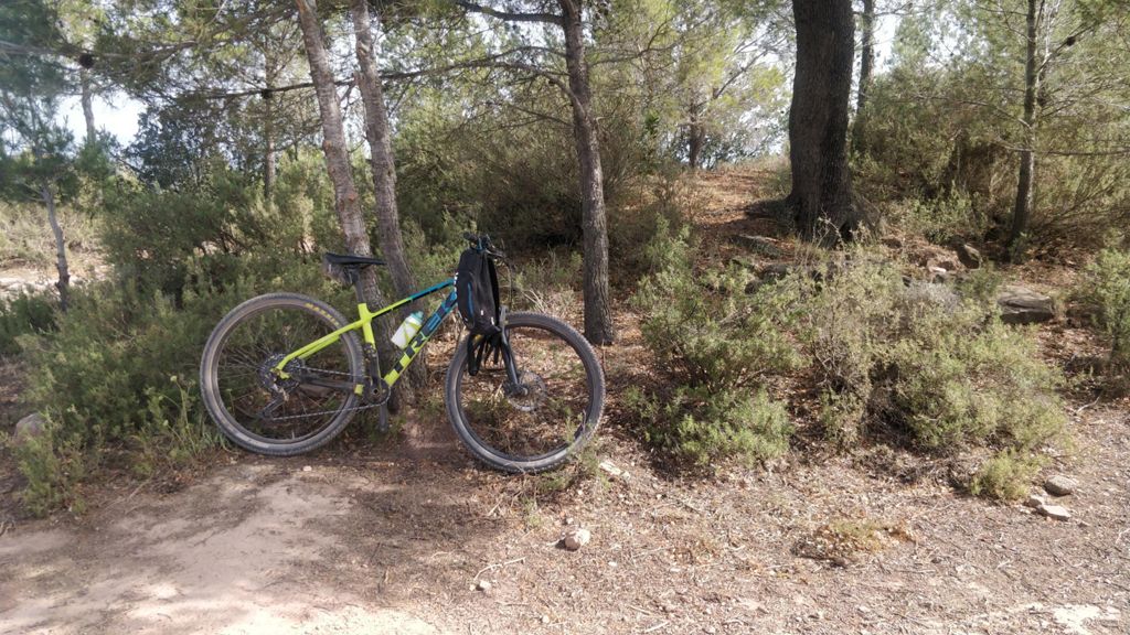
MTB
MTB
Ref..: 1055399
Published: 19/06/2022
Performed: 19/06/2022
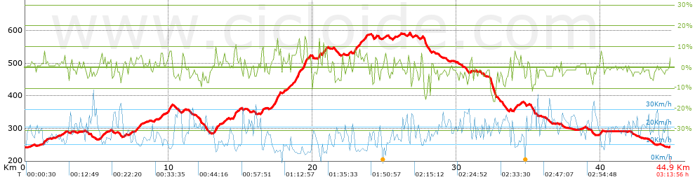
Distance in Km: 44.92
Climb in m: 745
IBP: 49 BYC

Bernat Bozzo
Author: Bernat Bozzo
290 published routes

Add to my Group or Club

 Height in m      Climb in %      Speed in Km/h      Speed < 2 Km/h

Climbs > 5%

Climbs >5% Climbs >10% Climbs >15% Climbs >20% Climbs >25%
 Steep slope of 149 m.   Average slope  Distances  Download as waypoint
1
 Km 1.278  6%  149 m
 Steep slope of 151 m.  Average slope  Distances  Download as waypoint
2
 Km 5.276  7%  151 m
 Steep slope of 139 m.  Average slope  Distances  Download as waypoint
3
 Km 9.442  6%  139 m
 Steep slope of 301 m.  Average slope  Distances  Download as waypoint
4
 Km 9.939  8%  301 m
 Steep slope of 179 m.  Average slope  Distances  Download as waypoint
5
 Km 13.183  9%  179 m
 Steep slope of 98 m.  Average slope  Distances  Download as waypoint
6
 Km 13.79  6%  98 m
 Steep slope of 215 m.  Average slope  Distances  Download as waypoint
7
 Km 14.504  9%  215 m
 Steep slope of 208 m.  Average slope  Distances  Download as waypoint
8
 Km 16.378  8%  208 m
 Steep slope of 547 m.  Average slope  Distances  Download as waypoint
9
 Km 17.179  8%  547 m
 Steep slope of 136 m.  Average slope  Distances  Download as waypoint
10
 Km 18.289  7%  136 m
 Steep slope of 102 m.  Average slope  Distances  Download as waypoint
11
 Km 18.53  5%  102 m
 Steep slope of 434 m.  Average slope  Distances  Download as waypoint
12
 Km 18.735  8%  206 m
13
 Km 18.941  11%  98 m
14
 Km 19.039  8%  130 m
 Steep slope of 282 m.  Average slope  Distances  Download as waypoint
15
 Km 19.305  6%  102 m
16
 Km 19.407  14%  148 m
17
 Km 19.555  10%  32 m
 Steep slope of 173 m.  Average slope  Distances  Download as waypoint
18
 Km 19.686  5%  173 m
 Steep slope of 132 m.  Average slope  Distances  Download as waypoint
19
 Km 20.4  8%  35 m
20
 Km 20.435  13%  97 m
 Steep slope of 100 m.  Average slope  Distances  Download as waypoint
21
 Km 20.706  10%  100 m
 Steep slope of 98 m.  Average slope  Distances  Download as waypoint
22
 Km 20.903  8%  98 m
 Steep slope of 99 m.  Average slope  Distances  Download as waypoint
23
 Km 22.504  7%  99 m
 Steep slope of 236 m.  Average slope  Distances  Download as waypoint
24
 Km 22.852  7%  236 m
 Steep slope of 134 m.  Average slope  Distances  Download as waypoint
25
 Km 23.189  7%  134 m
 Steep slope of 165 m.  Average slope  Distances  Download as waypoint
26
 Km 23.601  7%  165 m
 Steep slope of 102 m.  Average slope  Distances  Download as waypoint
27
 Km 24.341  7%  102 m
 Steep slope of 110 m.  Average slope  Distances  Download as waypoint
28
 Km 26.635  7%  110 m
 Steep slope of 132 m.  Average slope  Distances  Download as waypoint
29
 Km 34.007  7%  132 m
 Steep slope of 134 m.  Average slope  Distances  Download as waypoint
30
 Km 40.022  7%  134 m


Description of the route


Presence of ramps


 Climbs  Distance  % of the total  Speed  Your speed would be  Time  Your time would be
   15 - 30%  0.076  0.17  5.69  ?  0:00:48  ?
   10 - 15%  0.714  1.59  6.81  ?  0:06:17  ?
   5 - 10%  4.737  10.54  8.83  ?  0:32:10  ?
   1 - 5%  11.753  26.17  12.73  ?  0:55:23  ?
   Total*  17.279 Km  38.47 %  10.96 Km/h  ? Km/h    1:34:38 h  ? h  
 Flat
   1 - -1%  9.695 Km  21.58 %  19.14 Km/h  ? Km/h    0:30:24 h  ? h  
 Descents
   -1 - -5%  12.89  28.69  21.08  ?  0:36:41  ?
   -5 - -10%  4.18  9.31  22.07  ?  0:11:22  ?
   -10 - -15%  0.732  1.63  17.68  ?  0:02:29  ?
   -15 - -30%  0.143  0.32  19.86  ?  0:00:26  ?
   Total*  17.945 Km  39.95 %  21.13 Km/h  ? Km/h    0:50:58 h  ? h  
* The total has not necessarily coincide with the sum of the partials after correction of errors

How long would it take you?

How long would it take you to cover this route?
There are routes without a valid time information, but with your average stats you can assess the possible duration

Bernat Bozzo to cover this route you've need a time of:   2:56:00 h 
If you sign in and have a minimum of two tracks of this same modality, you can know your time for this route, calculated from your stats..


¿Cuanto consumirá tu E-BIKE?

Entra tu E-IBP (formato n,nn)

E-IBP :   X 49 = 


 Detected activity type =  ()
 Penalization due to track conditions: 63 %   ( > 50 % = MTB, < 50 % = RDB)
 Reliability of the track: B   (745/58/0/-/-/58)
 Correction level applied to the track: 0
DIFFICULTY OF THE ROUTE
IBP = 49 BYC
According to your statistics
 Your time in motion would be: ? h
Your average speed would be: ? Km/h
 

 Total Distance: 44.92 Km
 Analysed distance: 44.92 Km
 Linear distance: 0.02 Km

 Cumulated positive ramps: 744.8 m  list of points info
 Cumulated negative ramps: 742.9 m
 Maximum height: 593.2 m
 Minimum height: 241.6 m
 Climbing Ratio: 4.31 %
 Descent ratio: 4.14 %
 Cumulated postive ramps per Km: 16.58 m
 Cumulated negative ramps per Km: 16.54 m

 Total time: 3:13:56 h
 Time in movement: 2:56:00 h
 According to your statistics
 Your time in motion would be: ? h  
 Stopped time: 0:17:56 h
 Maximum slope filter: ~30 %
 Minimum separation analysed: ~30 m
 Number of points: 3544   (cad. 12.67 m)
 Significant waypoints: 1245   (cad. 36.08 m / 35.13 %)

 Changes in direction per Km: 12.27
 Changes in direction > 5º por Km: 8.97
 Cumulated straight stretches: 7.945 Km
 Straight stretches per Km: 176.87 m
 Penalized slope changes: 6
 Penalized slope changes per Km: 0.134

 Average speed in total: 13.9 Km/h
 Average speed while moving: 15.31 Km/h
 According to your statistics
 Your average speed would be: ? Km/h  
 Maximum sustained speed: 39.27 Km/h


Comments

You can be the first one in commenting this route

 
My comments
:
Add comment  (Registered users)
 
Notify me answers to my comment  Do not notify answers to my comment


Share this route with a friend

Your friend will receive a message with a link to this page:
will see your email and your user name if you do it as registered user.


Write here your name (optional)

E-mail address of your friend(s). You can include various addresses separated by commas

Text or comment (optional) maximum 255 characters long, 255 Available characters

As a non registered users you need to fill-in the captcha text.
  Change image
Type the image characters.
 
 Share with a friend


Visited history

Delete history

Marked routes for review later or compare

My favorites


  Notify anomaly in this route Share in Facebook