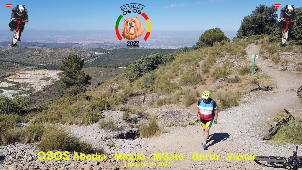
2022 06 04 osos abadia maullo mgato berta viznar

MTB
MTB
Ref..: 1051373
Published: 05/06/2022
Performed: 04/06/2022
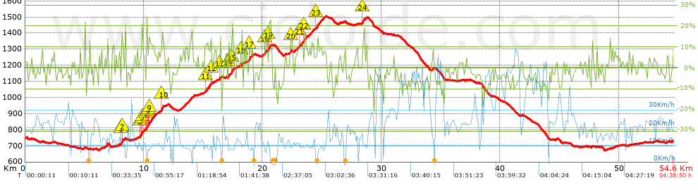
Distance in Km: 54.6
Climb in m: 1442
IBP: 124 BYC


 Height in m      Climb in %      Speed in Km/h      Speed < 2 Km/h

Climbs > 5%

Climbs >5% Climbs >10% Climbs >15% Climbs >20% Climbs >25%
 Steep slope of 257 m.   Average slope  Distances  Download as waypoint
1
 Km 6.692  7%  257 m
 Steep slope of 107 m.  Average slope  Distances  Download as waypoint
2
 Km 7.855  8%  107 m
 Steep slope of 210 m.  Average slope  Distances  Download as waypoint
3
 Km 8.068  6%  34 m
4
 Km 8.102  12%  33 m
5
 Km 8.135  21%  109 m
6
 Km 8.244  9%  34 m
 Steep slope of 406 m.  Average slope  Distances  Download as waypoint
7
 Km 9.659  10%  136 m
8
 Km 9.794  12%  100 m
9
 Km 9.894  13%  102 m
10
 Km 9.996  10%  68 m
 Steep slope of 1006 m.  Average slope  Distances  Download as waypoint
11
 Km 10.17  7%  29 m
12
 Km 10.199  11%  36 m
13
 Km 10.235  17%  100 m
14
 Km 10.335  11%  103 m
15
 Km 10.438  11%  274 m
16
 Km 10.712  8%  464 m
 Steep slope of 352 m.  Average slope  Distances  Download as waypoint
17
 Km 11.347  7%  110 m
18
 Km 11.457  14%  175 m
19
 Km 11.632  6%  67 m
 Steep slope of 354 m.  Average slope  Distances  Download as waypoint
20
 Km 13.015  6%  354 m
 Steep slope of 237 m.  Average slope  Distances  Download as waypoint
21
 Km 13.471  8%  237 m
 Steep slope of 206 m.  Average slope  Distances  Download as waypoint
22
 Km 13.807  10%  206 m
 Steep slope of 102 m.  Average slope  Distances  Download as waypoint
23
 Km 14.112  5%  102 m
 Steep slope of 523 m.  Average slope  Distances  Download as waypoint
24
 Km 15.145  11%  177 m
25
 Km 15.322  9%  310 m
26
 Km 15.632  14%  36 m
 Steep slope of 217 m.  Average slope  Distances  Download as waypoint
27
 Km 15.889  6%  217 m
 Steep slope of 160 m.  Average slope  Distances  Download as waypoint
28
 Km 16.359  14%  130 m
29
 Km 16.488  18%  30 m
 Steep slope of 117 m.  Average slope  Distances  Download as waypoint
30
 Km 16.841  7%  117 m
 Steep slope of 135 m.  Average slope  Distances  Download as waypoint
31
 Km 17.1  14%  99 m
32
 Km 17.199  19%  36 m
 Steep slope of 479 m.  Average slope  Distances  Download as waypoint
33
 Km 17.337  6%  31 m
34
 Km 17.367  15%  138 m
35
 Km 17.505  5%  310 m
 Steep slope of 173 m.  Average slope  Distances  Download as waypoint
36
 Km 18.164  12%  140 m
37
 Km 18.304  12%  33 m
 Steep slope of 501 m.  Average slope  Distances  Download as waypoint
38
 Km 18.754  7%  97 m
39
 Km 18.851  14%  99 m
40
 Km 18.95  7%  305 m
 Steep slope of 877 m.  Average slope  Distances  Download as waypoint
41
 Km 19.893  5%  311 m
42
 Km 20.204  10%  101 m
43
 Km 20.304  5%  174 m
44
 Km 20.478  15%  208 m
45
 Km 20.687  7%  83 m
 Steep slope of 68 m.  Average slope  Distances  Download as waypoint
46
 Km 22.336  9%  68 m
 Steep slope of 247 m.  Average slope  Distances  Download as waypoint
47
 Km 22.654  6%  247 m
 Steep slope of 480 m.  Average slope  Distances  Download as waypoint
48
 Km 23.012  9%  33 m
49
 Km 23.045  10%  275 m
50
 Km 23.32  8%  139 m
51
 Km 23.459  12%  33 m
 Steep slope of 1620 m.  Average slope  Distances  Download as waypoint
52
 Km 23.594  11%  72 m
53
 Km 23.666  6%  342 m
54
 Km 24.008  7%  103 m
55
 Km 24.112  15%  33 m
56
 Km 24.145  8%  315 m
57
 Km 24.459  10%  171 m
58
 Km 24.631  9%  584 m
 Steep slope of 134 m.  Average slope  Distances  Download as waypoint
59
 Km 26.43  7%  134 m
 Steep slope of 116 m.  Average slope  Distances  Download as waypoint
60
 Km 27.836  5%  116 m
 Steep slope of 36 m.  Average slope  Distances  Download as waypoint
61
 Km 28.362  14%  36 m
 Steep slope of 223 m.  Average slope  Distances  Download as waypoint
62
 Km 28.504  16%  38 m
63
 Km 28.541  6%  185 m
 Steep slope of 103 m.  Average slope  Distances  Download as waypoint
64
 Km 34.298  11%  103 m
 Steep slope of 106 m.  Average slope  Distances  Download as waypoint
65
 Km 44.667  7%  106 m
 Steep slope of 185 m.  Average slope  Distances  Download as waypoint
66
 Km 49.609  5%  185 m
 Steep slope of 173 m.  Average slope  Distances  Download as waypoint
67
 Km 53.993  5%  173 m


Description of the route


Presence of ramps


 Climbs  Distance  % of the total  Speed  Your speed would be  Time  Your time would be
   15 - 30%  1.485  2.72  7.74  ?  0:11:31  ?
   10 - 15%  3.116  5.71  9.21  ?  0:20:18  ?
   5 - 10%  7.976  14.61  11.54  ?  0:41:28  ?
   1 - 5%  7.645  14  16.23  ?  0:28:16  ?
   Total*  20.223 Km  37.04 %  11.95 Km/h  ? Km/h    1:41:33 h  ? h  
 Flat
   1 - -1%  9.434 Km  17.28 %  17.09 Km/h  ? Km/h    0:33:07 h  ? h  
 Descents
   -1 - -5%  12.18  22.31  22.87  ?  0:31:57  ?
   -5 - -10%  9.925  18.18  24.69  ?  0:24:07  ?
   -10 - -15%  2.099  3.84  13.54  ?  0:09:18  ?
   -15 - -30%  0.741  1.36  10.58  ?  0:04:12  ?
   Total*  24.945 Km  45.68 %  21.51 Km/h  ? Km/h    1:09:34 h  ? h  
* The total has not necessarily coincide with the sum of the partials after correction of errors

How long would it take you?

How long would it take you to cover this route?
There are routes without a valid time information, but with your average stats you can assess the possible duration

Armando_Rodriguez_Nieto to cover this route you've need a time of:   3:24:14 h 
If you sign in and have a minimum of two tracks of this same modality, you can know your time for this route, calculated from your stats..


¿Cuanto consumirá tu E-BIKE?

Entra tu E-IBP (formato n,nn)

E-IBP :   X 124 = 


 Detected activity type =  ()
 Penalization due to track conditions: 82 %   ( > 50 % = MTB, < 50 % = RDB)
 Reliability of the track: C   (1446/52/0/-/-/52)
 Correction level applied to the track: 0
DIFFICULTY OF THE ROUTE
IBP = 124 BYC
According to your statistics
 Your time in motion would be: ? h
Your average speed would be: ? Km/h
 

 Total Distance: 54.6 Km
 Analysed distance: 54.6 Km
 Linear distance: 0.14 Km

 Cumulated positive ramps: 1442.29 m  list of points info
 Cumulated negative ramps: 1460.37 m
 Maximum height: 1504 m
 Minimum height: 673 m
 Climbing Ratio: 7.13 %
 Descent ratio: 5.85 %
 Cumulated postive ramps per Km: 26.42 m
 Cumulated negative ramps per Km: 26.75 m

 Total time: 4:38:50 h
 Time in movement: 3:24:14 h
 According to your statistics
 Your time in motion would be: ? h  
 Stopped time: 1:14:36 h
 Maximum slope filter: ~30 %
 Minimum separation analysed: ~30 m
 Number of points: 4296   (cad. 12.71 m)
 Significant waypoints: 1522   (cad. 35.88 m / 35.43 %)

 Changes in direction per Km: 10.6
 Changes in direction > 5º por Km: 6.76
 Cumulated straight stretches: 12.448 Km
 Straight stretches per Km: 227.99 m
 Penalized slope changes: 12
 Penalized slope changes per Km: 0.22

 Average speed in total: 11.75 Km/h
 Average speed while moving: 16.04 Km/h
 According to your statistics
 Your average speed would be: ? Km/h  
 Maximum sustained speed: 64.77 Km/h


Comments

You can be the first one in commenting this route

 
My comments
:
Add comment  (Registered users)
 
Notify me answers to my comment  Do not notify answers to my comment


Share this route with a friend

Your friend will receive a message with a link to this page:
will see your email and your user name if you do it as registered user.


Write here your name (optional)

E-mail address of your friend(s). You can include various addresses separated by commas

Text or comment (optional) maximum 255 characters long, 255 Available characters

As a non registered users you need to fill-in the captcha text.
  Change image
Type the image characters.
 
 Share with a friend


Visited history

Delete history

Marked routes for review later or compare

My favorites


  Notify anomaly in this route Share in Facebook