2022 05 02 osos cogollos collado agua kalirfakir cogollos

MTB
MTB
Ref..: 1042967
Published: 03/05/2022
Performed: 02/05/2022
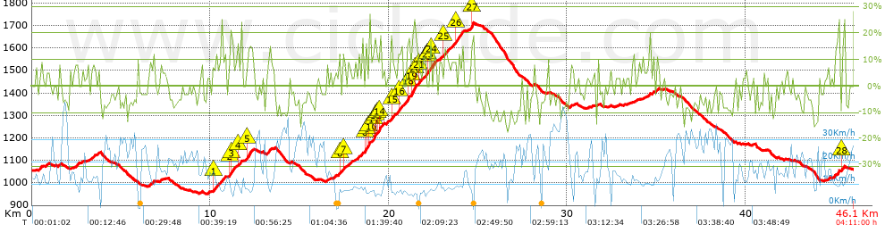
Distance in Km: 46.14
Climb in m: 1452
IBP: 133 BYC


 Height in m      Climb in %      Speed in Km/h      Speed < 2 Km/h

Climbs > 5%

Climbs >5% Climbs >10% Climbs >15% Climbs >20% Climbs >25%
 Steep slope of 101 m.   Average slope  Distances  Download as waypoint
1
 Km 0.472  9%  101 m
 Steep slope of 217 m.  Average slope  Distances  Download as waypoint
2
 Km 0.765  6%  217 m
 Steep slope of 108 m.  Average slope  Distances  Download as waypoint
3
 Km 1.485  7%  108 m
 Steep slope of 221 m.  Average slope  Distances  Download as waypoint
4
 Km 2.429  9%  221 m
 Steep slope of 423 m.  Average slope  Distances  Download as waypoint
5
 Km 3.118  6%  423 m
 Steep slope of 172 m.  Average slope  Distances  Download as waypoint
6
 Km 3.651  8%  172 m
 Steep slope of 247 m.  Average slope  Distances  Download as waypoint
7
 Km 6.591  7%  247 m
 Steep slope of 117 m.  Average slope  Distances  Download as waypoint
8
 Km 7.205  7%  117 m
 Steep slope of 113 m.  Average slope  Distances  Download as waypoint
9
 Km 9.855  7%  113 m
 Steep slope of 516 m.  Average slope  Distances  Download as waypoint
10
 Km 10.123  6%  69 m
11
 Km 10.192  10%  138 m
12
 Km 10.33  7%  309 m
 Steep slope of 101 m.  Average slope  Distances  Download as waypoint
13
 Km 10.743  9%  101 m
 Steep slope of 308 m.  Average slope  Distances  Download as waypoint
14
 Km 11.087  14%  36 m
15
 Km 11.123  13%  98 m
16
 Km 11.221  10%  174 m
 Steep slope of 167 m.  Average slope  Distances  Download as waypoint
17
 Km 11.54  11%  104 m
18
 Km 11.644  10%  63 m
 Steep slope of 338 m.  Average slope  Distances  Download as waypoint
19
 Km 12.11  14%  206 m
20
 Km 12.316  8%  132 m
 Steep slope of 344 m.  Average slope  Distances  Download as waypoint
21
 Km 13.209  7%  344 m
 Steep slope of 144 m.  Average slope  Distances  Download as waypoint
22
 Km 16.862  6%  144 m
 Steep slope of 230 m.  Average slope  Distances  Download as waypoint
23
 Km 17.113  7%  135 m
24
 Km 17.248  14%  95 m
 Steep slope of 510 m.  Average slope  Distances  Download as waypoint
25
 Km 17.442  11%  103 m
26
 Km 17.544  5%  139 m
27
 Km 17.684  8%  268 m
 Steep slope of 165 m.  Average slope  Distances  Download as waypoint
28
 Km 18.126  7%  165 m
 Steep slope of 630 m.  Average slope  Distances  Download as waypoint
29
 Km 18.393  7%  265 m
30
 Km 18.658  14%  98 m
31
 Km 18.756  11%  98 m
32
 Km 18.855  15%  34 m
33
 Km 18.888  10%  135 m
 Steep slope of 638 m.  Average slope  Distances  Download as waypoint
34
 Km 19.056  7%  69 m
35
 Km 19.125  12%  34 m
36
 Km 19.159  18%  101 m
37
 Km 19.26  6%  35 m
38
 Km 19.295  10%  102 m
39
 Km 19.396  11%  65 m
40
 Km 19.461  19%  99 m
41
 Km 19.561  6%  133 m
 Steep slope of 103 m.  Average slope  Distances  Download as waypoint
42
 Km 19.88  11%  103 m
 Steep slope of 634 m.  Average slope  Distances  Download as waypoint
43
 Km 20.123  12%  133 m
44
 Km 20.256  8%  269 m
45
 Km 20.525  11%  166 m
46
 Km 20.691  11%  66 m
 Steep slope of 1875 m.  Average slope  Distances  Download as waypoint
47
 Km 20.79  8%  66 m
48
 Km 20.856  12%  33 m
49
 Km 20.89  7%  133 m
50
 Km 21.022  15%  95 m
51
 Km 21.118  13%  31 m
52
 Km 21.149  7%  101 m
53
 Km 21.249  9%  66 m
54
 Km 21.315  16%  132 m
55
 Km 21.447  16%  135 m
56
 Km 21.582  6%  103 m
57
 Km 21.685  13%  97 m
58
 Km 21.783  8%  268 m
59
 Km 22.051  10%  101 m
60
 Km 22.152  12%  100 m
61
 Km 22.251  9%  69 m
62
 Km 22.32  12%  212 m
63
 Km 22.532  10%  133 m
 Steep slope of 510 m.  Average slope  Distances  Download as waypoint
64
 Km 22.841  7%  241 m
65
 Km 23.082  10%  136 m
66
 Km 23.218  11%  133 m
 Steep slope of 755 m.  Average slope  Distances  Download as waypoint
67
 Km 23.449  9%  307 m
68
 Km 23.756  12%  210 m
69
 Km 23.966  11%  238 m
 Steep slope of 198 m.  Average slope  Distances  Download as waypoint
70
 Km 24.553  7%  67 m
71
 Km 24.621  19%  131 m
 Steep slope of 170 m.  Average slope  Distances  Download as waypoint
72
 Km 30.196  6%  170 m
 Steep slope of 104 m.  Average slope  Distances  Download as waypoint
73
 Km 33.48  5%  104 m
 Steep slope of 95 m.  Average slope  Distances  Download as waypoint
74
 Km 33.73  8%  95 m
 Steep slope of 182 m.  Average slope  Distances  Download as waypoint
75
 Km 34.239  5%  182 m
 Steep slope of 112 m.  Average slope  Distances  Download as waypoint
76
 Km 34.521  5%  112 m
 Steep slope of 314 m.  Average slope  Distances  Download as waypoint
77
 Km 34.78  7%  314 m
 Steep slope of 115 m.  Average slope  Distances  Download as waypoint
78
 Km 44.626  9%  115 m
 Steep slope of 151 m.  Average slope  Distances  Download as waypoint
79
 Km 44.878  5%  151 m
 Steep slope of 138 m.  Average slope  Distances  Download as waypoint
80
 Km 45.137  15%  138 m
 Steep slope of 149 m.  Average slope  Distances  Download as waypoint
81
 Km 45.412  12%  109 m
82
 Km 45.521  25%  40 m


Description of the route


Presence of ramps


 Climbs  Distance  % of the total  Speed  Your speed would be  Time  Your time would be
   15 - 30%  2.074  4.5  7.49  ?  0:16:37  ?
   10 - 15%  3.005  6.51  9.79  ?  0:18:25  ?
   5 - 10%  7.734  16.76  10.62  ?  0:43:41  ?
   1 - 5%  4.698  10.18  12.62  ?  0:22:20  ?
   Total*  17.511 Km  37.95 %  10.4 Km/h  ? Km/h    1:41:03 h  ? h  
 Flat
   1 - -1%  6.33 Km  13.72 %  15.67 Km/h  ? Km/h    0:24:14 h  ? h  
 Descents
   -1 - -5%  7.714  16.72  18.85  ?  0:24:33  ?
   -5 - -10%  11.448  24.81  23.79  ?  0:28:52  ?
   -10 - -15%  2.596  5.63  20.05  ?  0:07:46  ?
   -15 - -30%  0.539  1.17  9.56  ?  0:03:23  ?
   Total*  22.296 Km  48.33 %  20.72 Km/h  ? Km/h    1:04:34 h  ? h  
* The total has not necessarily coincide with the sum of the partials after correction of errors

How long would it take you?

How long would it take you to cover this route?
There are routes without a valid time information, but with your average stats you can assess the possible duration

Armando_Rodriguez_Nieto to cover this route you've need a time of:   3:09:51 h 
If you sign in and have a minimum of two tracks of this same modality, you can know your time for this route, calculated from your stats..


¿Cuanto consumirá tu E-BIKE?

Entra tu E-IBP (formato n,nn)

E-IBP :   X 133 = 


 Detected activity type =  ()
 Penalization due to track conditions: 82 %   ( > 50 % = MTB, < 50 % = RDB)
 Reliability of the track: B   (1457/63/0/-/-/63)
 Correction level applied to the track: 0
DIFFICULTY OF THE ROUTE
IBP = 133 BYC
According to your statistics
 Your time in motion would be: ? h
Your average speed would be: ? Km/h
 

 Total Distance: 46.14 Km
 Analysed distance: 46.14 Km
 Linear distance: 0.01 Km

 Cumulated positive ramps: 1452.37 m  list of points info
 Cumulated negative ramps: 1445.97 m
 Maximum height: 1712 m
 Minimum height: 951 m
 Climbing Ratio: 8.29 %
 Descent ratio: 6.49 %
 Cumulated postive ramps per Km: 31.48 m
 Cumulated negative ramps per Km: 31.34 m

 Total time: 4:11:00 h
 Time in movement: 3:09:51 h
 According to your statistics
 Your time in motion would be: ? h  
 Stopped time: 1:01:09 h
 Maximum slope filter: ~30 %
 Minimum separation analysed: ~30 m
 Number of points: 3663   (cad. 12.6 m)
 Significant waypoints: 1298   (cad. 35.54 m / 35.44 %)

 Changes in direction per Km: 10.36
 Changes in direction > 5º por Km: 7.72
 Cumulated straight stretches: 8.78 Km
 Straight stretches per Km: 190.29 m
 Penalized slope changes: 9
 Penalized slope changes per Km: 0.195

 Average speed in total: 11.03 Km/h
 Average speed while moving: 14.58 Km/h
 According to your statistics
 Your average speed would be: ? Km/h  
 Maximum sustained speed: 49.43 Km/h


Comments

You can be the first one in commenting this route

 
My comments
:
Add comment  (Registered users)
 
Notify me answers to my comment  Do not notify answers to my comment


Share this route with a friend

Your friend will receive a message with a link to this page:
will see your email and your user name if you do it as registered user.


Write here your name (optional)

E-mail address of your friend(s). You can include various addresses separated by commas

Text or comment (optional) maximum 255 characters long, 255 Available characters

As a non registered users you need to fill-in the captcha text.
  Change image
Type the image characters.
 
 Share with a friend


Visited history

Delete history

Marked routes for review later or compare

My favorites


  Notify anomaly in this route Share in Facebook