2022 04 19 mansos malaha cortijo blanco sierra pera

Road
Road
Ref..: 1039930
Published: 19/04/2022
Performed: 19/04/2022
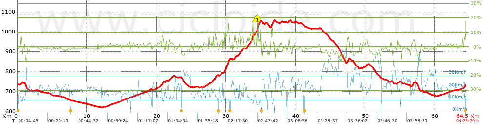
Distance in Km: 64.48
Climb in m: 751
IBP: 48 BYC


 Height in m      Climb in %      Speed in Km/h      Speed < 2 Km/h

Climbs > 5%

Climbs >5% Climbs >10% Climbs >15% Climbs >20% Climbs >25%
 Steep slope of 100 m.   Average slope  Distances  Download as waypoint
1
 Km 0.518  8%  100 m
 Steep slope of 205 m.  Average slope  Distances  Download as waypoint
2
 Km 20.842  7%  205 m
 Steep slope of 106 m.  Average slope  Distances  Download as waypoint
3
 Km 27.544  7%  106 m
 Steep slope of 104 m.  Average slope  Distances  Download as waypoint
4
 Km 28.075  7%  104 m
 Steep slope of 180 m.  Average slope  Distances  Download as waypoint
5
 Km 28.393  8%  180 m
 Steep slope of 642 m.  Average slope  Distances  Download as waypoint
6
 Km 29.751  7%  324 m
7
 Km 30.075  11%  142 m
8
 Km 30.217  10%  176 m
 Steep slope of 140 m.  Average slope  Distances  Download as waypoint
9
 Km 31.196  8%  140 m
 Steep slope of 187 m.  Average slope  Distances  Download as waypoint
10
 Km 31.842  9%  187 m
 Steep slope of 147 m.  Average slope  Distances  Download as waypoint
11
 Km 32.237  5%  147 m
 Steep slope of 170 m.  Average slope  Distances  Download as waypoint
12
 Km 32.965  5%  170 m
 Steep slope of 139 m.  Average slope  Distances  Download as waypoint
13
 Km 33.419  7%  139 m
 Steep slope of 244 m.  Average slope  Distances  Download as waypoint
14
 Km 33.67  8%  102 m
15
 Km 33.771  12%  107 m
16
 Km 33.878  13%  35 m
 Steep slope of 174 m.  Average slope  Distances  Download as waypoint
17
 Km 34.123  8%  174 m
 Steep slope of 275 m.  Average slope  Distances  Download as waypoint
18
 Km 34.398  6%  102 m
19
 Km 34.501  23%  104 m
20
 Km 34.605  6%  69 m
 Steep slope of 211 m.  Average slope  Distances  Download as waypoint
21
 Km 36.511  11%  211 m
 Steep slope of 208 m.  Average slope  Distances  Download as waypoint
22
 Km 47.435  7%  208 m
 Steep slope of 112 m.  Average slope  Distances  Download as waypoint
23
 Km 56.866  8%  112 m


Description of the route


Presence of ramps


 Climbs  Distance  % of the total  Speed  Your speed would be  Time  Your time would be
   15 - 30%  0.182  0.28  9.09  ?  0:01:12  ?
   10 - 15%  0.714  1.11  8.8  ?  0:04:52  ?
   5 - 10%  3.325  5.16  12.71  ?  0:15:42  ?
   1 - 5%  17.012  26.38  15.98  ?  1:03:53  ?
   Total*  21.233 Km  32.93 %  14.87 Km/h  ? Km/h    1:25:39 h  ? h  
 Flat
   1 - -1%  21.401 Km  33.19 %  19.33 Km/h  ? Km/h    1:06:26 h  ? h  
 Descents
   -1 - -5%  17.716  27.48  23.56  ?  0:45:07  ?
   -5 - -10%  3.983  6.18  29.69  ?  0:08:03  ?
   -10 - -15%  0.148  0.23  25.33  ?  0:00:21  ?
   -15 - -30%  0  0  0  ?  0:00:00  ?
   Total*  21.847 Km  33.88 %  24.49 Km/h  ? Km/h    0:53:31 h  ? h  
* The total has not necessarily coincide with the sum of the partials after correction of errors

How long would it take you?

How long would it take you to cover this route?
There are routes without a valid time information, but with your average stats you can assess the possible duration

Armando_Rodriguez_Nieto to cover this route you've need a time of:   3:25:36 h 
If you sign in and have a minimum of two tracks of this same modality, you can know your time for this route, calculated from your stats..


¿Cuanto consumirá tu E-BIKE?

Entra tu E-IBP (formato n,nn)

E-IBP :   X 48 = 


 Detected activity type =  ()
 Penalization due to track conditions: 35 %   ( > 50 % = MTB, < 50 % = RDB)
 Reliability of the track: B   (750/66/0/-/-/66)
 Correction level applied to the track: 0
DIFFICULTY OF THE ROUTE
IBP = 48 BYC
According to your statistics
 Your time in motion would be: ? h
Your average speed would be: ? Km/h
 

 Total Distance: 64.48 Km
 Analysed distance: 64.48 Km
 Linear distance: 0 Km

 Cumulated positive ramps: 750.7 m  list of points info
 Cumulated negative ramps: 732.4 m
 Maximum height: 1058.5 m
 Minimum height: 621 m
 Climbing Ratio: 3.54 %
 Descent ratio: 3.35 %
 Cumulated postive ramps per Km: 11.64 m
 Cumulated negative ramps per Km: 11.36 m

 Total time: 4:23:29 h
 Time in movement: 3:25:36 h
 According to your statistics
 Your time in motion would be: ? h  
 Stopped time: 0:57:53 h
 Maximum slope filter: ~30 %
 Minimum separation analysed: ~30 m
 Number of points: 5021   (cad. 12.84 m)
 Significant waypoints: 1799   (cad. 35.84 m / 35.83 %)

 Changes in direction per Km: 12.53
 Changes in direction > 5º por Km: 5.46
 Cumulated straight stretches: 24.402 Km
 Straight stretches per Km: 378.44 m
 Penalized slope changes: 9
 Penalized slope changes per Km: 0.14

 Average speed in total: 14.68 Km/h
 Average speed while moving: 18.82 Km/h
 According to your statistics
 Your average speed would be: ? Km/h  
 Maximum sustained speed: 56.06 Km/h


Comments

You can be the first one in commenting this route

 
My comments
:
Add comment  (Registered users)
 
Notify me answers to my comment  Do not notify answers to my comment


Share this route with a friend

Your friend will receive a message with a link to this page:
will see your email and your user name if you do it as registered user.


Write here your name (optional)

E-mail address of your friend(s). You can include various addresses separated by commas

Text or comment (optional) maximum 255 characters long, 255 Available characters

As a non registered users you need to fill-in the captcha text.
  Change image
Type the image characters.
 
 Share with a friend


Visited history

Delete history

Marked routes for review later or compare

My favorites


  Notify anomaly in this route Share in Facebook