Viajeros Románticos

MTB
MTB
Ref..: 1027021
Published: 16/02/2022
Performed: 13/02/2022
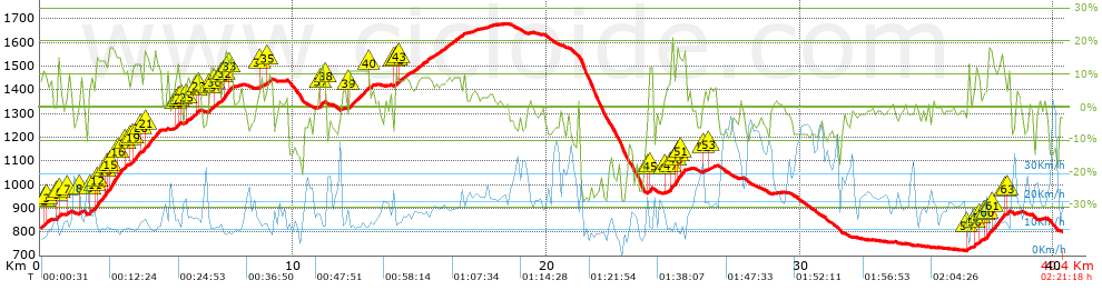
Distance in Km: 40.35
Climb in m: 1448
IBP: 120 BYC

Near ...
Barrio De La Vega, Barrio De Monachil, Cajar, Cenes De La Vega, Huetor Vega, Monachil
fernan2g
Author: fernan2g
1943 published routes

Add to my Group or Club

 Height in m      Climb in %      Speed in Km/h      Speed < 2 Km/h

Climbs > 10%

Climbs >5% Climbs >10% Climbs >15% Climbs >20% Climbs >25%
 Steep slope of 105 m.   Average slope  Distances  Download as waypoint
1
 Km 0.135  11%  105 m
 Steep slope of 106 m.  Average slope  Distances  Download as waypoint
2
 Km 0.704  14%  106 m
 Steep slope of 2211 m.  Average slope  Distances  Download as waypoint
3
 Km 2.156  10%  41 m
4
 Km 2.197  15%  105 m
5
 Km 2.302  14%  269 m
6
 Km 2.571  15%  107 m
7
 Km 2.679  15%  104 m
8
 Km 2.782  16%  293 m
9
 Km 3.075  13%  322 m
10
 Km 3.615  12%  369 m
11
 Km 4.149  14%  601 m
 Steep slope of 260 m.  Average slope  Distances  Download as waypoint
12
 Km 5.443  12%  105 m
13
 Km 6.117  11%  155 m
 Steep slope of 557 m.  Average slope  Distances  Download as waypoint
14
 Km 6.707  11%  151 m
15
 Km 7.198  13%  101 m
16
 Km 7.299  16%  137 m
17
 Km 7.435  13%  168 m
 Steep slope of 166 m.  Average slope  Distances  Download as waypoint
18
 Km 11.069  12%  166 m
 Steep slope of 795 m.  Average slope  Distances  Download as waypoint
19
 Km 12.191  11%  795 m
 Steep slope of 103 m.  Average slope  Distances  Download as waypoint
20
 Km 14.021  11%  103 m
 Steep slope of 138 m.  Average slope  Distances  Download as waypoint
21
 Km 24.031  13%  138 m
 Steep slope of 541 m.  Average slope  Distances  Download as waypoint
22
 Km 24.886  13%  210 m
23
 Km 25.096  18%  101 m
24
 Km 25.197  17%  69 m
25
 Km 25.267  10%  35 m
26
 Km 25.301  14%  195 m
 Steep slope of 913 m.  Average slope  Distances  Download as waypoint
27
 Km 36.902  10%  151 m
28
 Km 37.378  14%  37 m
29
 Km 37.416  17%  139 m
30
 Km 37.554  13%  479 m
31
 Km 38.175  11%  107 m


Description of the route


Presence of ramps


 Climbs  Distance  % of the total  Speed  Your speed would be  Time  Your time would be
   15 - 30%  1.333  3.3  10.91  ?  0:07:20  ?
   10 - 15%  4.811  11.92  12.08  ?  0:23:54  ?
   5 - 10%  6.43  15.94  15.08  ?  0:25:35  ?
   1 - 5%  5.388  13.35  18.09  ?  0:17:52  ?
   Total*  17.962 Km  44.51 %  14.43 Km/h  ? Km/h    1:14:41 h  ? h  
 Flat
   1 - -1%  4.424 Km  10.96 %  19.33 Km/h  ? Km/h    0:13:44 h  ? h  
 Descents
   -1 - -5%  7.284  18.05  23.02  ?  0:18:59  ?
   -5 - -10%  6.348  15.73  31.88  ?  0:11:57  ?
   -10 - -15%  1.507  3.73  20.39  ?  0:04:26  ?
   -15 - -30%  2.826  7  9.68  ?  0:17:31  ?
   Total*  17.965 Km  44.52 %  20.38 Km/h  ? Km/h    0:52:53 h  ? h  
* The total has not necessarily coincide with the sum of the partials after correction of errors

How long would it take you?

How long would it take you to cover this route?
There are routes without a valid time information, but with your average stats you can assess the possible duration

fernan2g to cover this route you've need a time of:   2:21:18 h 
If you sign in and have a minimum of two tracks of this same modality, you can know your time for this route, calculated from your stats..


¿Cuanto consumirá tu E-BIKE?

Entra tu E-IBP (formato n,nn)

E-IBP :   X 120 = 


 Detected activity type =  ()
 Penalization due to track conditions: 60 %   ( > 50 % = MTB, < 50 % = RDB)
 Reliability of the track: A   (1448/80/0/-/-/80)
 Correction level applied to the track: 0
DIFFICULTY OF THE ROUTE
IBP = 120 BYC
According to your statistics
 Your time in motion would be: ? h
Your average speed would be: ? Km/h
 

 Total Distance: 40.35 Km
 Analysed distance: 40.35 Km
 Linear distance: 0.14 Km

 Cumulated positive ramps: 1448.3 m  list of points info
 Cumulated negative ramps: 1455.8 m
 Maximum height: 1678.4 m
 Minimum height: 720.9 m
 Climbing Ratio: 8.06 %
 Descent ratio: 8.1 %
 Cumulated postive ramps per Km: 35.89 m
 Cumulated negative ramps per Km: 36.08 m

 Total time: 2:21:18 h
 Time in movement: 2:21:18 h
 According to your statistics
 Your time in motion would be: ? h  
 Stopped time: 0:00:00 h
 Maximum slope filter: ~30 %
 Minimum separation analysed: ~30 m
 Number of points: 3244   (cad. 12.44 m)
 Significant waypoints: 1134   (cad. 35.58 m / 34.96 %)

 Changes in direction per Km: 11.67
 Changes in direction > 5º por Km: 8.92
 Cumulated straight stretches: 5.75 Km
 Straight stretches per Km: 142.5 m
 Penalized slope changes: 13
 Penalized slope changes per Km: 0.322

 Average speed in total: 17.13 Km/h
 Average speed while moving: 17.13 Km/h
 According to your statistics
 Your average speed would be: ? Km/h  
 Maximum sustained speed: 60.14 Km/h


Comments

You can be the first one in commenting this route

 
My comments
:
Add comment  (Registered users)
 
Notify me answers to my comment  Do not notify answers to my comment


Share this route with a friend

Your friend will receive a message with a link to this page:
will see your email and your user name if you do it as registered user.


Write here your name (optional)

E-mail address of your friend(s). You can include various addresses separated by commas

Text or comment (optional) maximum 255 characters long, 255 Available characters

As a non registered users you need to fill-in the captcha text.
  Change image
Type the image characters.
 
 Share with a friend


Visited history

Delete history

Marked routes for review later or compare

My favorites


  Notify anomaly in this route Share in Facebook