Goikolendi y bajada por Olarreaga

MTB
MTB
Ref..: 1023007
Published: 30/01/2022
Performed: 30/01/2022
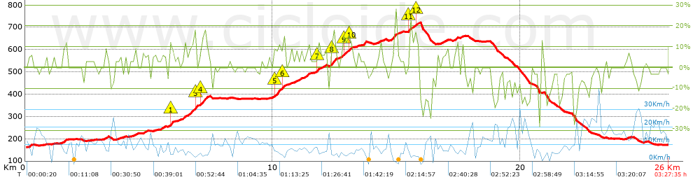
Distance in Km: 25.98
Climb in m: 737
IBP: 69 BYC


 Height in m      Climb in %      Speed in Km/h      Speed < 2 Km/h

Climbs > 5%

Climbs >5% Climbs >10% Climbs >15% Climbs >20% Climbs >25%
 Steep slope of 121 m.   Average slope  Distances  Download as waypoint
1
 Km 0.119  6%  121 m
 Steep slope of 210 m.  Average slope  Distances  Download as waypoint
2
 Km 1.484  8%  210 m
 Steep slope of 104 m.  Average slope  Distances  Download as waypoint
3
 Km 3.236  10%  104 m
 Steep slope of 151 m.  Average slope  Distances  Download as waypoint
4
 Km 3.702  5%  151 m
 Steep slope of 112 m.  Average slope  Distances  Download as waypoint
5
 Km 4.719  7%  112 m
 Steep slope of 218 m.  Average slope  Distances  Download as waypoint
6
 Km 5.451  6%  218 m
 Steep slope of 101 m.  Average slope  Distances  Download as waypoint
7
 Km 5.846  16%  101 m
 Steep slope of 529 m.  Average slope  Distances  Download as waypoint
8
 Km 6.374  8%  283 m
9
 Km 6.657  9%  176 m
10
 Km 6.832  18%  34 m
11
 Km 6.866  25%  36 m
 Steep slope of 270 m.  Average slope  Distances  Download as waypoint
12
 Km 7.114  18%  137 m
13
 Km 7.25  8%  133 m
 Steep slope of 574 m.  Average slope  Distances  Download as waypoint
14
 Km 9.849  5%  251 m
15
 Km 10.1  13%  179 m
16
 Km 10.279  9%  108 m
17
 Km 10.387  17%  36 m
 Steep slope of 261 m.  Average slope  Distances  Download as waypoint
18
 Km 10.888  6%  261 m
 Steep slope of 223 m.  Average slope  Distances  Download as waypoint
19
 Km 11.299  9%  223 m
 Steep slope of 317 m.  Average slope  Distances  Download as waypoint
20
 Km 11.704  6%  72 m
21
 Km 11.777  12%  106 m
22
 Km 11.882  6%  139 m
 Steep slope of 298 m.  Average slope  Distances  Download as waypoint
23
 Km 12.298  9%  68 m
24
 Km 12.366  13%  201 m
25
 Km 12.567  10%  29 m
 Steep slope of 553 m.  Average slope  Distances  Download as waypoint
26
 Km 12.701  6%  143 m
27
 Km 12.844  12%  100 m
28
 Km 12.945  8%  103 m
29
 Km 13.048  12%  102 m
30
 Km 13.15  9%  105 m
 Steep slope of 153 m.  Average slope  Distances  Download as waypoint
31
 Km 14.189  5%  153 m
 Steep slope of 298 m.  Average slope  Distances  Download as waypoint
32
 Km 14.763  10%  298 m
 Steep slope of 450 m.  Average slope  Distances  Download as waypoint
33
 Km 15.484  14%  103 m
34
 Km 15.587  6%  140 m
35
 Km 15.727  11%  104 m
36
 Km 15.831  14%  70 m
37
 Km 15.9  12%  33 m
 Steep slope of 180 m.  Average slope  Distances  Download as waypoint
38
 Km 16.832  5%  180 m
 Steep slope of 113 m.  Average slope  Distances  Download as waypoint
39
 Km 17.333  9%  113 m
 Steep slope of 149 m.  Average slope  Distances  Download as waypoint
40
 Km 17.587  7%  149 m


Description of the route


Presence of ramps


 Climbs  Distance  % of the total  Speed  Your speed would be  Time  Your time would be
   15 - 30%  0.693  2.67  4.67  ?  0:08:54  ?
   10 - 15%  1.531  5.89  5.81  ?  0:15:48  ?
   5 - 10%  4.216  16.22  7.41  ?  0:34:09  ?
   1 - 5%  4.39  16.89  8.87  ?  0:29:42  ?
   Total*  10.83 Km  41.68 %  7.34 Km/h  ? Km/h    1:28:33 h  ? h  
 Flat
   1 - -1%  6.463 Km  24.87 %  11.09 Km/h  ? Km/h    0:34:59 h  ? h  
 Descents
   -1 - -5%  3.05  11.74  12.86  ?  0:14:14  ?
   -5 - -10%  3.086  11.88  15.24  ?  0:12:09  ?
   -10 - -15%  1.185  4.56  10.86  ?  0:06:33  ?
   -15 - -30%  1.369  5.27  10.21  ?  0:08:03  ?
   Total*  8.691 Km  33.45 %  12.72 Km/h  ? Km/h    0:40:59 h  ? h  
* The total has not necessarily coincide with the sum of the partials after correction of errors

How long would it take you?

How long would it take you to cover this route?
There are routes without a valid time information, but with your average stats you can assess the possible duration

Iker_Barbarrubio_Cortijo to cover this route you've need a time of:   2:44:31 h 
If you sign in and have a minimum of two tracks of this same modality, you can know your time for this route, calculated from your stats..


¿Cuanto consumirá tu E-BIKE?

Entra tu E-IBP (formato n,nn)

E-IBP :   X 69 = 


 Detected activity type =  ()
 Penalization due to track conditions: 74 %   ( > 50 % = MTB, < 50 % = RDB)
 Reliability of the track: B   (737/68/0/-/-/68)
 Correction level applied to the track: 0
DIFFICULTY OF THE ROUTE
IBP = 69 BYC
According to your statistics
 Your time in motion would be: ? h
Your average speed would be: ? Km/h
 

 Total Distance: 25.98 Km
 Analysed distance: 25.98 Km
 Linear distance: 0.14 Km

 Cumulated positive ramps: 737 m  list of points info
 Cumulated negative ramps: 725 m
 Maximum height: 726 m
 Minimum height: 162 m
 Climbing Ratio: 6.8 %
 Descent ratio: 8.34 %
 Cumulated postive ramps per Km: 28.37 m
 Cumulated negative ramps per Km: 27.91 m

 Total time: 3:27:35 h
 Time in movement: 2:44:31 h
 According to your statistics
 Your time in motion would be: ? h  
 Stopped time: 0:43:04 h
 Maximum slope filter: ~30 %
 Minimum separation analysed: ~30 m
 Number of points: 2014   (cad. 12.9 m)
 Significant waypoints: 718   (cad. 36.19 m / 35.65 %)

 Changes in direction per Km: 12.93
 Changes in direction > 5º por Km: 8.39
 Cumulated straight stretches: 4.028 Km
 Straight stretches per Km: 155.04 m
 Penalized slope changes: 7
 Penalized slope changes per Km: 0.269

 Average speed in total: 7.51 Km/h
 Average speed while moving: 9.48 Km/h
 According to your statistics
 Your average speed would be: ? Km/h  
 Maximum sustained speed: 32.59 Km/h


Comments

You can be the first one in commenting this route

 
My comments
:
Add comment  (Registered users)
 
Notify me answers to my comment  Do not notify answers to my comment


Share this route with a friend

Your friend will receive a message with a link to this page:
will see your email and your user name if you do it as registered user.


Write here your name (optional)

E-mail address of your friend(s). You can include various addresses separated by commas

Text or comment (optional) maximum 255 characters long, 255 Available characters

As a non registered users you need to fill-in the captcha text.
  Change image
Type the image characters.
 
 Share with a friend


Visited history

Delete history

Marked routes for review later or compare

My favorites


  Notify anomaly in this route Share in Facebook