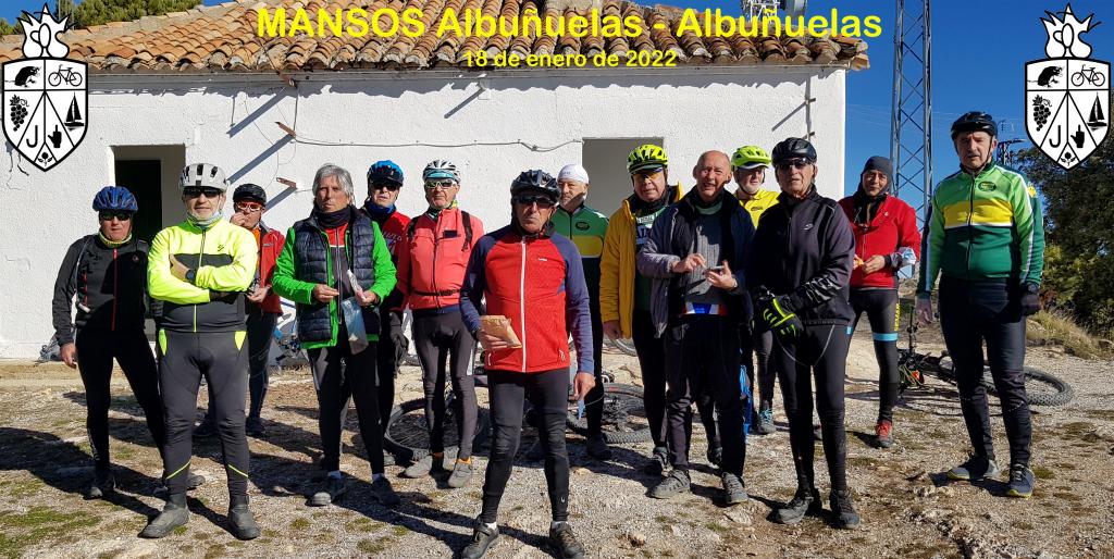
2022 01 18 mansos albuñuelas albuñuelas

MTB
MTB
Ref..: 1020623
Published: 19/01/2022
Performed: 18/01/2022
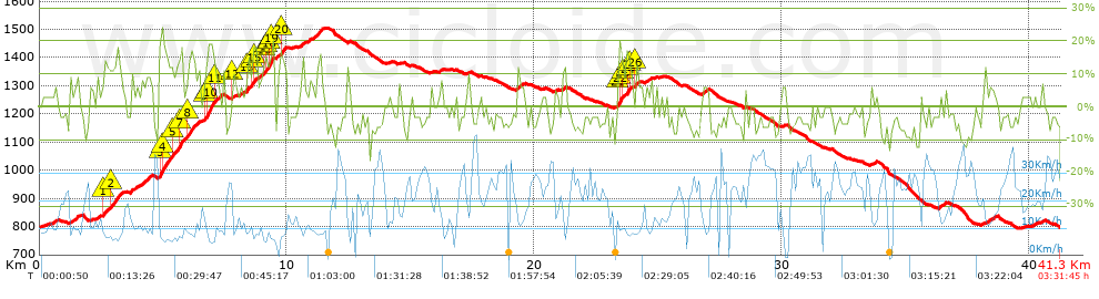
Distance in Km: 41.32
Climb in m: 1155
IBP: 109 BYC


 Height in m      Climb in %      Speed in Km/h      Speed < 2 Km/h

Climbs > 5%

Climbs >5% Climbs >10% Climbs >15% Climbs >20% Climbs >25%
 Steep slope of 177 m.   Average slope  Distances  Download as waypoint
1
 Km 0.48  6%  177 m
 Steep slope of 348 m.  Average slope  Distances  Download as waypoint
2
 Km 1.235  7%  348 m
 Steep slope of 137 m.  Average slope  Distances  Download as waypoint
3
 Km 2.305  8%  137 m
 Steep slope of 769 m.  Average slope  Distances  Download as waypoint
4
 Km 2.549  7%  67 m
5
 Km 2.616  11%  168 m
6
 Km 2.784  9%  102 m
7
 Km 2.885  12%  200 m
8
 Km 3.085  11%  232 m
 Steep slope of 273 m.  Average slope  Distances  Download as waypoint
9
 Km 3.667  7%  273 m
 Steep slope of 488 m.  Average slope  Distances  Download as waypoint
10
 Km 4.077  8%  488 m
 Steep slope of 1587 m.  Average slope  Distances  Download as waypoint
11
 Km 4.843  18%  163 m
12
 Km 5.006  13%  366 m
13
 Km 5.372  10%  267 m
14
 Km 5.64  14%  36 m
15
 Km 5.676  19%  99 m
16
 Km 5.775  9%  98 m
17
 Km 5.873  8%  137 m
18
 Km 6.01  14%  237 m
19
 Km 6.247  9%  184 m
 Steep slope of 683 m.  Average slope  Distances  Download as waypoint
20
 Km 6.614  5%  76 m
21
 Km 6.69  12%  73 m
22
 Km 6.763  17%  264 m
23
 Km 7.027  16%  67 m
24
 Km 7.094  8%  203 m
 Steep slope of 103 m.  Average slope  Distances  Download as waypoint
25
 Km 7.81  11%  103 m
 Steep slope of 141 m.  Average slope  Distances  Download as waypoint
26
 Km 8.094  6%  141 m
 Steep slope of 1115 m.  Average slope  Distances  Download as waypoint
27
 Km 8.345  6%  32 m
28
 Km 8.377  13%  105 m
29
 Km 8.482  6%  135 m
30
 Km 8.617  13%  100 m
31
 Km 8.717  13%  31 m
32
 Km 8.748  8%  101 m
33
 Km 8.849  6%  170 m
34
 Km 9.018  9%  68 m
35
 Km 9.087  16%  100 m
36
 Km 9.187  10%  103 m
37
 Km 9.29  17%  103 m
38
 Km 9.393  18%  34 m
39
 Km 9.427  21%  33 m
 Steep slope of 383 m.  Average slope  Distances  Download as waypoint
40
 Km 9.59  6%  141 m
41
 Km 9.731  13%  173 m
42
 Km 9.904  10%  69 m
 Steep slope of 173 m.  Average slope  Distances  Download as waypoint
43
 Km 10.516  8%  173 m
 Steep slope of 211 m.  Average slope  Distances  Download as waypoint
44
 Km 10.874  6%  211 m
 Steep slope of 337 m.  Average slope  Distances  Download as waypoint
45
 Km 11.183  9%  337 m
 Steep slope of 115 m.  Average slope  Distances  Download as waypoint
46
 Km 16.172  7%  115 m
 Steep slope of 271 m.  Average slope  Distances  Download as waypoint
47
 Km 19.3  8%  271 m
 Steep slope of 100 m.  Average slope  Distances  Download as waypoint
48
 Km 21.121  6%  100 m
 Steep slope of 206 m.  Average slope  Distances  Download as waypoint
49
 Km 23.41  12%  34 m
50
 Km 23.444  18%  139 m
51
 Km 23.583  15%  33 m
 Steep slope of 241 m.  Average slope  Distances  Download as waypoint
52
 Km 23.72  16%  104 m
53
 Km 23.824  14%  36 m
54
 Km 23.86  8%  101 m
 Steep slope of 164 m.  Average slope  Distances  Download as waypoint
55
 Km 24.065  12%  98 m
56
 Km 24.162  8%  66 m
 Steep slope of 176 m.  Average slope  Distances  Download as waypoint
57
 Km 24.546  6%  176 m
 Steep slope of 209 m.  Average slope  Distances  Download as waypoint
58
 Km 26.762  6%  209 m
 Steep slope of 218 m.  Average slope  Distances  Download as waypoint
59
 Km 36.389  6%  218 m
 Steep slope of 323 m.  Average slope  Distances  Download as waypoint
60
 Km 38.242  6%  323 m
 Steep slope of 112 m.  Average slope  Distances  Download as waypoint
61
 Km 40.169  5%  112 m


Description of the route


Presence of ramps


 Climbs  Distance  % of the total  Speed  Your speed would be  Time  Your time would be
   15 - 30%  1.573  3.81  8.12  ?  0:11:37  ?
   10 - 15%  2.745  6.64  9.2  ?  0:17:54  ?
   5 - 10%  6.1  14.77  11.19  ?  0:32:43  ?
   1 - 5%  4.242  10.27  13.49  ?  0:18:52  ?
   Total*  14.66 Km  35.48 %  10.85 Km/h  ? Km/h    1:21:06 h  ? h  
 Flat
   1 - -1%  5.631 Km  13.63 %  17.27 Km/h  ? Km/h    0:19:34 h  ? h  
 Descents
   -1 - -5%  9.143  22.13  21.96  ?  0:24:59  ?
   -5 - -10%  10.457  25.31  24.27  ?  0:25:51  ?
   -10 - -15%  1.249  3.02  24.18  ?  0:03:06  ?
   -15 - -30%  0.176  0.43  9.88  ?  0:01:04  ?
   Total*  21.025 Km  50.89 %  22.94 Km/h  ? Km/h    0:55:00 h  ? h  
* The total has not necessarily coincide with the sum of the partials after correction of errors

How long would it take you?

How long would it take you to cover this route?
There are routes without a valid time information, but with your average stats you can assess the possible duration

Armando_Rodriguez_Nieto to cover this route you've need a time of:   2:35:40 h 
If you sign in and have a minimum of two tracks of this same modality, you can know your time for this route, calculated from your stats..


¿Cuanto consumirá tu E-BIKE?

Entra tu E-IBP (formato n,nn)

E-IBP :   X 109 = 


 Detected activity type =  ()
 Penalization due to track conditions: 76 %   ( > 50 % = MTB, < 50 % = RDB)
 Reliability of the track: B   (1158/67/0/-/-/67)
 Correction level applied to the track: 0
DIFFICULTY OF THE ROUTE
IBP = 109 BYC
According to your statistics
 Your time in motion would be: ? h
Your average speed would be: ? Km/h
 

 Total Distance: 41.32 Km
 Analysed distance: 41.32 Km
 Linear distance: 0 Km

 Cumulated positive ramps: 1154.52 m  list of points info
 Cumulated negative ramps: 1158.52 m
 Maximum height: 1508.7 m
 Minimum height: 795 m
 Climbing Ratio: 7.88 %
 Descent ratio: 5.51 %
 Cumulated postive ramps per Km: 27.94 m
 Cumulated negative ramps per Km: 28.04 m

 Total time: 3:31:45 h
 Time in movement: 2:35:40 h
 According to your statistics
 Your time in motion would be: ? h  
 Stopped time: 0:56:05 h
 Maximum slope filter: ~30 %
 Minimum separation analysed: ~30 m
 Number of points: 3197   (cad. 12.92 m)
 Significant waypoints: 1168   (cad. 35.37 m / 36.53 %)

 Changes in direction per Km: 10.87
 Changes in direction > 5º por Km: 7.38
 Cumulated straight stretches: 10.725 Km
 Straight stretches per Km: 259.56 m
 Penalized slope changes: 7
 Penalized slope changes per Km: 0.169

 Average speed in total: 11.71 Km/h
 Average speed while moving: 15.93 Km/h
 According to your statistics
 Your average speed would be: ? Km/h  
 Maximum sustained speed: 46.98 Km/h


Comments

You can be the first one in commenting this route

 
My comments
:
Add comment  (Registered users)
 
Notify me answers to my comment  Do not notify answers to my comment


Share this route with a friend

Your friend will receive a message with a link to this page:
will see your email and your user name if you do it as registered user.


Write here your name (optional)

E-mail address of your friend(s). You can include various addresses separated by commas

Text or comment (optional) maximum 255 characters long, 255 Available characters

As a non registered users you need to fill-in the captcha text.
  Change image
Type the image characters.
 
 Share with a friend


Visited history

Delete history

Marked routes for review later or compare

My favorites


  Notify anomaly in this route Share in Facebook