Llanars, Taga

MTB
MTB
Ref..: 1000430
Published: 09/10/2021
Performed: 09/10/2021
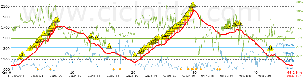
Distance in Km: 46.17
Climb in m: 2066
IBP: 191 BYC

Near ...
Camprodon, Colonia Estevenell, La, Llanars, Sant Bernabe De Les Tenes, Vilallonga De Ter
jarcass
Author: jarcass
1338 published routes

Add to my Group or Club

 Height in m      Climb in %      Speed in Km/h      Speed < 2 Km/h

Climbs > 10%

Climbs >5% Climbs >10% Climbs >15% Climbs >20% Climbs >25%
 Steep slope of 2034 m.   Average slope  Distances  Download as waypoint
1
 Km 1.453  12%  456 m
2
 Km 2.977  10%  160 m
3
 Km 3.764  10%  267 m
4
 Km 4.032  18%  146 m
5
 Km 4.178  14%  117 m
6
 Km 4.295  18%  140 m
7
 Km 4.435  15%  37 m
8
 Km 4.67  12%  184 m
9
 Km 4.854  18%  494 m
10
 Km 5.348  11%  33 m
 Steep slope of 640 m.  Average slope  Distances  Download as waypoint
11
 Km 5.995  11%  69 m
12
 Km 6.064  17%  35 m
13
 Km 6.1  28%  253 m
14
 Km 6.353  19%  141 m
15
 Km 6.494  18%  108 m
16
 Km 6.602  18%  34 m
 Steep slope of 574 m.  Average slope  Distances  Download as waypoint
17
 Km 6.786  18%  146 m
18
 Km 6.932  22%  72 m
19
 Km 7.004  28%  258 m
20
 Km 7.263  20%  30 m
21
 Km 7.293  13%  68 m
 Steep slope of 997 m.  Average slope  Distances  Download as waypoint
22
 Km 21.127  12%  168 m
23
 Km 21.414  13%  313 m
24
 Km 22.5  12%  404 m
25
 Km 23.217  12%  112 m
 Steep slope of 329 m.  Average slope  Distances  Download as waypoint
26
 Km 23.439  12%  329 m
 Steep slope of 110 m.  Average slope  Distances  Download as waypoint
27
 Km 24.669  15%  110 m
 Steep slope of 983 m.  Average slope  Distances  Download as waypoint
28
 Km 25.293  15%  31 m
29
 Km 25.323  28%  111 m
30
 Km 25.434  24%  43 m
31
 Km 25.478  15%  109 m
32
 Km 25.587  16%  34 m
33
 Km 26.068  14%  232 m
34
 Km 26.416  10%  211 m
35
 Km 26.627  12%  106 m
36
 Km 26.733  14%  107 m
37
 Km 26.84  16%  105 m
 Steep slope of 2114 m.  Average slope  Distances  Download as waypoint
38
 Km 27.566  12%  264 m
39
 Km 27.83  18%  424 m
40
 Km 28.254  17%  35 m
41
 Km 28.289  10%  106 m
42
 Km 28.395  13%  145 m
43
 Km 28.54  16%  131 m
44
 Km 28.671  12%  181 m
45
 Km 28.852  18%  478 m
46
 Km 29.33  20%  126 m
47
 Km 29.456  28%  192 m
48
 Km 29.648  28%  68 m
49
 Km 29.716  19%  70 m
 Steep slope of 306 m.  Average slope  Distances  Download as waypoint
50
 Km 36.573  12%  66 m
51
 Km 36.639  16%  174 m
52
 Km 36.813  17%  66 m
 Steep slope of 145 m.  Average slope  Distances  Download as waypoint
53
 Km 42.324  12%  145 m


Description of the route


Presence of ramps


 Climbs  Distance  % of the total  Speed  Your speed would be  Time  Your time would be
   15 - 30%  4.497  9.74  4.56  ?  0:59:09  ?
   10 - 15%  4.295  9.3  5.79  ?  0:44:31  ?
   5 - 10%  6.396  13.85  8.26  ?  0:46:28  ?
   1 - 5%  4.971  10.77  10.17  ?  0:29:19  ?
   Total*  20.159 Km  43.66 %  6.74 Km/h  ? Km/h    2:59:27 h  ? h  
 Flat
   1 - -1%  2.514 Km  5.44 %  9.01 Km/h  ? Km/h    0:16:44 h  ? h  
 Descents
   -1 - -5%  6.418  13.9  12.32  ?  0:31:15  ?
   -5 - -10%  9.37  20.29  15.24  ?  0:36:54  ?
   -10 - -15%  4.321  9.36  13.26  ?  0:19:33  ?
   -15 - -30%  3.398  7.36  9.49  ?  0:21:29  ?
   Total*  23.507 Km  50.91 %  12.92 Km/h  ? Km/h    1:49:11 h  ? h  
* The total has not necessarily coincide with the sum of the partials after correction of errors

How long would it take you?

How long would it take you to cover this route?
There are routes without a valid time information, but with your average stats you can assess the possible duration

jarcass to cover this route you've need a time of:   5:05:22 h 
If you sign in and have a minimum of two tracks of this same modality, you can know your time for this route, calculated from your stats..


¿Cuanto consumirá tu E-BIKE?

Entra tu E-IBP (formato n,nn)

E-IBP :   X 191 = 


 Detected activity type =  ()
 Penalization due to track conditions: 63 %   ( > 50 % = MTB, < 50 % = RDB)
 Reliability of the track: A   (2061/84/0/-/-/84)
 Correction level applied to the track: 0
DIFFICULTY OF THE ROUTE
IBP = 191 BYC
According to your statistics
 Your time in motion would be: ? h
Your average speed would be: ? Km/h
 

 Total Distance: 46.17 Km
 Analysed distance: 46.17 Km
 Linear distance: 0.01 Km

 Cumulated positive ramps: 2065.9 m  list of points info
 Cumulated negative ramps: 2067.5 m
 Maximum height: 2020.7 m
 Minimum height: 982.1 m
 Climbing Ratio: 10.25 %
 Descent ratio: 8.8 %
 Cumulated postive ramps per Km: 44.75 m
 Cumulated negative ramps per Km: 44.78 m

 Total time: 6:37:51 h
 Time in movement: 5:05:22 h
 According to your statistics
 Your time in motion would be: ? h  
 Stopped time: 1:32:29 h
 Maximum slope filter: ~30 %
 Minimum separation analysed: ~30 m
 Number of points: 3141   (cad. 14.7 m)
 Significant waypoints: 1261   (cad. 36.65 m / 40.15 %)

 Changes in direction per Km: 11.91
 Changes in direction > 5º por Km: 9.31
 Cumulated straight stretches: 5.46 Km
 Straight stretches per Km: 118.26 m
 Penalized slope changes: 18
 Penalized slope changes per Km: 0.39

 Average speed in total: 6.96 Km/h
 Average speed while moving: 9.07 Km/h
 According to your statistics
 Your average speed would be: ? Km/h  
 Maximum sustained speed: 43.78 Km/h


Comments

You can be the first one in commenting this route

 
My comments
:
Add comment  (Registered users)
 
Notify me answers to my comment  Do not notify answers to my comment


Share this route with a friend

Your friend will receive a message with a link to this page:
will see your email and your user name if you do it as registered user.


Write here your name (optional)

E-mail address of your friend(s). You can include various addresses separated by commas

Text or comment (optional) maximum 255 characters long, 255 Available characters

As a non registered users you need to fill-in the captcha text.
  Change image
Type the image characters.
 
 Share with a friend


Visited history

Delete history

Marked routes for review later or compare

My favorites


  Notify anomaly in this route Share in Facebook