Mare à mare centre j4 Cozzano

Hiking
Hiking
Ref..: 1057923
Published: 05/07/2022
Performed: 05/07/2022
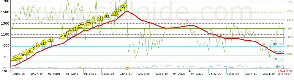
Distance in Km: 15.33
Climb in m: 1082
IBP: 95 HKG

Autor 33750
Author: Autor 33750
206 published routes

Add to my Group or Club

 Height in m      Climb in %      Speed in Km/h      Speed < 2 Km/h

Climbs > 5%

Climbs >5% Climbs >10% Climbs >15% Climbs >20% Climbs >25%
 Steep slope of 3950 m.   Average slope  Distances  Download as waypoint
1
 Km 0.129  8%  62 m
2
 Km 0.191  13%  30 m
3
 Km 0.221  15%  95 m
4
 Km 0.316  14%  63 m
5
 Km 0.38  10%  92 m
6
 Km 0.471  21%  162 m
7
 Km 0.633  17%  221 m
8
 Km 0.854  16%  225 m
9
 Km 1.079  25%  143 m
10
 Km 1.222  24%  217 m
11
 Km 1.439  23%  31 m
12
 Km 1.47  30%  30 m
13
 Km 1.5  11%  280 m
14
 Km 1.78  16%  93 m
15
 Km 1.873  14%  187 m
16
 Km 2.06  7%  95 m
17
 Km 2.154  13%  30 m
18
 Km 2.184  15%  94 m
19
 Km 2.278  10%  29 m
20
 Km 2.307  9%  454 m
21
 Km 2.761  6%  96 m
22
 Km 2.857  14%  36 m
23
 Km 2.893  16%  31 m
24
 Km 2.924  22%  202 m
25
 Km 3.126  24%  100 m
26
 Km 3.226  20%  157 m
27
 Km 3.384  14%  154 m
28
 Km 3.538  19%  94 m
29
 Km 3.632  19%  225 m
30
 Km 3.857  22%  63 m
31
 Km 3.92  26%  66 m
32
 Km 3.986  15%  93 m
 Steep slope of 621 m.  Average slope  Distances  Download as waypoint
33
 Km 4.241  14%  171 m
34
 Km 4.411  21%  155 m
35
 Km 4.566  13%  204 m
36
 Km 4.77  12%  91 m
 Steep slope of 222 m.  Average slope  Distances  Download as waypoint
37
 Km 4.956  10%  125 m
38
 Km 5.081  24%  97 m
 Steep slope of 422 m.  Average slope  Distances  Download as waypoint
39
 Km 5.208  5%  94 m
40
 Km 5.302  9%  33 m
41
 Km 5.335  17%  132 m
42
 Km 5.467  13%  163 m
 Steep slope of 756 m.  Average slope  Distances  Download as waypoint
43
 Km 5.758  10%  62 m
44
 Km 5.82  26%  202 m
45
 Km 6.022  25%  95 m
46
 Km 6.116  26%  127 m
47
 Km 6.243  27%  70 m
48
 Km 6.313  20%  98 m
49
 Km 6.411  19%  31 m
50
 Km 6.443  17%  71 m
 Steep slope of 132 m.  Average slope  Distances  Download as waypoint
51
 Km 9.421  5%  132 m
 Steep slope of 230 m.  Average slope  Distances  Download as waypoint
52
 Km 9.849  5%  230 m


Description of the route


Presence of ramps


 Climbs  Distance  % of the total  Speed  Your speed would be  Time  Your time would be
   15 - 30%  2.967  19.35  2.14  ?  1:23:01  ?
   10 - 15%  1.273  8.3  2.44  ?  0:31:21  ?
   5 - 10%  1.977  12.89  3.26  ?  0:36:24  ?
   1 - 5%  1.108  7.23  4.2  ?  0:15:49  ?
   Total*  7.672 Km  50.05 %  2.59 Km/h  ? Km/h    2:57:40 h  ? h  
 Flat
   1 - -1%  1.458 Km  9.51 %  3.38 Km/h  ? Km/h    0:25:52 h  ? h  
 Descents
   -1 - -5%  0.908  5.92  3.81  ?  0:14:17  ?
   -5 - -10%  1.525  9.95  4.24  ?  0:21:36  ?
   -10 - -15%  1.05  6.85  3.59  ?  0:17:34  ?
   -15 - -30%  2.485  16.21  3.11  ?  0:48:01  ?
   Total*  6.199 Km  40.44 %  3.45 Km/h  ? Km/h    1:47:51 h  ? h  
* The total has not necessarily coincide with the sum of the partials after correction of errors

How long would it take you?

How long would it take you to cover this route?
There are routes without a valid time information, but with your average stats you can assess the possible duration

Autor 33750 to cover this route you've need a time of:   5:11:23 h 
If you sign in and have a minimum of two tracks of this same modality, you can know your time for this route, calculated from your stats..


 Detected activity type =  ()
 Penalization due to track conditions: 0 %   ( > 50 % = MTB, < 50 % = RDB)
 Reliability of the track: A   (1082/90/0/-/-/90)
 Correction level applied to the track: 0
DIFFICULTY OF THE ROUTE
IBP = 95 HKG
According to your statistics
 Your time in motion would be: ? h
Your average speed would be: ? Km/h
 

 Total Distance: 15.33 Km
 Analysed distance: 15.33 Km
 Linear distance: 8.73 Km

 Cumulated positive ramps: 1082 m  list of points info
 Cumulated negative ramps: 858.07 m
 Maximum height: 1523 m
 Minimum height: 538 m
 Climbing Ratio: 14.1 %
 Descent ratio: 13.84 %
 Cumulated postive ramps per Km: 70.58 m
 Cumulated negative ramps per Km: 55.97 m

 Total time: 5:57:06 h
 Time in movement: 5:11:23 h
 According to your statistics
 Your time in motion would be: ? h  
 Stopped time: 0:45:43 h
 Maximum slope filter: ~55 %
 Minimum separation analysed: ~30 m
 Number of points: 1472   (cad. 10.41 m)
 Significant waypoints: 474   (cad. 32.34 m / 32.2 %)

 Changes in direction per Km: 16.76
 Changes in direction > 5º por Km: 14.29
 Cumulated straight stretches: 1.342 Km
 Straight stretches per Km: 87.54 m
 Penalized slope changes: 7
 Penalized slope changes per Km: 0.457

 Average speed in total: 2.58 Km/h
 Average speed while moving: 2.95 Km/h
 According to your statistics
 Your average speed would be: ? Km/h  
 Maximum sustained speed: 6.83 Km/h


Comments

You can be the first one in commenting this route

 
My comments
:
Add comment  (Registered users)
 
Notify me answers to my comment  Do not notify answers to my comment


Share this route with a friend

Your friend will receive a message with a link to this page:
will see your email and your user name if you do it as registered user.


Write here your name (optional)

E-mail address of your friend(s). You can include various addresses separated by commas

Text or comment (optional) maximum 255 characters long, 255 Available characters

As a non registered users you need to fill-in the captcha text.
  Change image
Type the image characters.
 
 Share with a friend


Visited history

Delete history

Marked routes for review later or compare

My favorites


  Notify anomaly in this route Share in Facebook