Talajara 2021

Road
Road
Ref..: 999026
Published: 03/10/2021
Performed: 02/10/2021
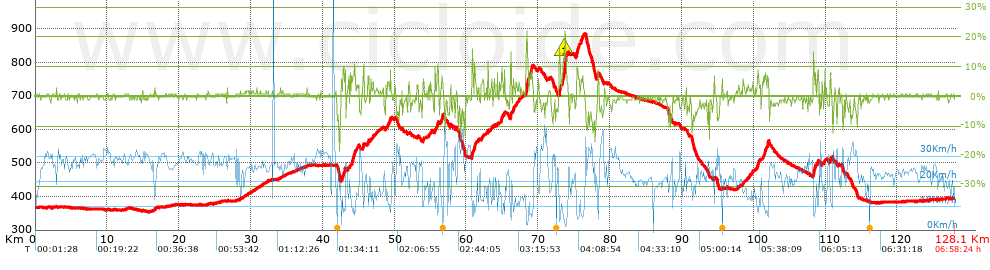
Distance in Km: 128.07
Climb in m: 1298
IBP: 122 BYC


 Height in m      Climb in %      Speed in Km/h      Speed < 2 Km/h

Climbs > 5%

Climbs >5% Climbs >10% Climbs >15% Climbs >20% Climbs >25%
 Steep slope of 147 m.   Average slope  Distances  Download as waypoint
1
 Km 42.635  5%  147 m
 Steep slope of 236 m.  Average slope  Distances  Download as waypoint
2
 Km 42.885  8%  236 m
 Steep slope of 102 m.  Average slope  Distances  Download as waypoint
3
 Km 43.514  6%  102 m
 Steep slope of 307 m.  Average slope  Distances  Download as waypoint
4
 Km 44.032  8%  307 m
 Steep slope of 135 m.  Average slope  Distances  Download as waypoint
5
 Km 44.446  9%  135 m
 Steep slope of 138 m.  Average slope  Distances  Download as waypoint
6
 Km 45.636  9%  138 m
 Steep slope of 210 m.  Average slope  Distances  Download as waypoint
7
 Km 46.266  7%  210 m
 Steep slope of 135 m.  Average slope  Distances  Download as waypoint
8
 Km 49.377  8%  135 m
 Steep slope of 142 m.  Average slope  Distances  Download as waypoint
9
 Km 53.979  6%  142 m
 Steep slope of 179 m.  Average slope  Distances  Download as waypoint
10
 Km 55.616  6%  179 m
 Steep slope of 203 m.  Average slope  Distances  Download as waypoint
11
 Km 55.948  8%  203 m
 Steep slope of 174 m.  Average slope  Distances  Download as waypoint
12
 Km 56.513  7%  174 m
 Steep slope of 202 m.  Average slope  Distances  Download as waypoint
13
 Km 60.792  12%  103 m
14
 Km 60.895  10%  99 m
 Steep slope of 203 m.  Average slope  Distances  Download as waypoint
15
 Km 61.102  8%  203 m
 Steep slope of 197 m.  Average slope  Distances  Download as waypoint
16
 Km 64.86  8%  197 m
 Steep slope of 107 m.  Average slope  Distances  Download as waypoint
17
 Km 65.277  8%  107 m
 Steep slope of 164 m.  Average slope  Distances  Download as waypoint
18
 Km 66.148  7%  33 m
19
 Km 66.181  14%  131 m
 Steep slope of 175 m.  Average slope  Distances  Download as waypoint
20
 Km 66.529  7%  175 m
 Steep slope of 393 m.  Average slope  Distances  Download as waypoint
21
 Km 68.325  14%  257 m
22
 Km 68.582  8%  136 m
 Steep slope of 432 m.  Average slope  Distances  Download as waypoint
23
 Km 68.849  8%  432 m
 Steep slope of 1095 m.  Average slope  Distances  Download as waypoint
24
 Km 72.945  14%  164 m
25
 Km 73.109  7%  279 m
26
 Km 73.389  8%  103 m
27
 Km 73.492  13%  196 m
28
 Km 73.688  18%  221 m
29
 Km 73.909  15%  31 m
30
 Km 73.94  8%  101 m
 Steep slope of 440 m.  Average slope  Distances  Download as waypoint
31
 Km 75.303  8%  440 m
 Steep slope of 390 m.  Average slope  Distances  Download as waypoint
32
 Km 75.916  6%  390 m
 Steep slope of 138 m.  Average slope  Distances  Download as waypoint
33
 Km 78.312  11%  104 m
34
 Km 78.416  11%  34 m
 Steep slope of 235 m.  Average slope  Distances  Download as waypoint
35
 Km 100.527  7%  235 m
 Steep slope of 139 m.  Average slope  Distances  Download as waypoint
36
 Km 101.28  5%  139 m
 Steep slope of 281 m.  Average slope  Distances  Download as waypoint
37
 Km 101.531  6%  281 m
 Steep slope of 195 m.  Average slope  Distances  Download as waypoint
38
 Km 101.918  9%  195 m
 Steep slope of 304 m.  Average slope  Distances  Download as waypoint
39
 Km 108.33  13%  136 m
40
 Km 108.467  8%  168 m
 Steep slope of 104 m.  Average slope  Distances  Download as waypoint
41
 Km 108.948  8%  104 m
 Steep slope of 118 m.  Average slope  Distances  Download as waypoint
42
 Km 109.769  5%  118 m
 Steep slope of 136 m.  Average slope  Distances  Download as waypoint
43
 Km 110.663  8%  136 m


Description of the route


Presence of ramps


 Climbs  Distance  % of the total  Speed  Your speed would be  Time  Your time would be
   15 - 30%  0.511  0.4  4.26  ?  0:07:12  ?
   10 - 15%  1.747  1.36  6.99  ?  0:15:00  ?
   5 - 10%  6.96  5.43  9.69  ?  0:43:07  ?
   1 - 5%  22.407  17.5  17.31  ?  1:17:41  ?
   Total*  31.624 Km  24.69 %  13.27 Km/h  ? Km/h    2:23:00 h  ? h  
 Flat
   1 - -1%  65.193 Km  50.9 %  25.24 Km/h  ? Km/h    2:34:57 h  ? h  
 Descents
   -1 - -5%  21.674  16.92  24.61  ?  0:52:50  ?
   -5 - -10%  8.055  6.29  25.78  ?  0:18:45  ?
   -10 - -15%  1.274  0.99  25.33  ?  0:03:01  ?
   -15 - -30%  0.25  0.19  11.38  ?  0:01:19  ?
   Total*  31.252 Km  24.4 %  24.7 Km/h  ? Km/h    1:15:55 h  ? h  
* The total has not necessarily coincide with the sum of the partials after correction of errors

How long would it take you?

How long would it take you to cover this route?
There are routes without a valid time information, but with your average stats you can assess the possible duration

Antonio_Alejandro_Martinez_Diaz to cover this route you've need a time of:   6:13:52 h 
If you sign in and have a minimum of two tracks of this same modality, you can know your time for this route, calculated from your stats..


¿Cuanto consumirá tu E-BIKE?

Entra tu E-IBP (formato n,nn)

E-IBP :   X 122 = 


 Detected activity type =  ()
 Penalization due to track conditions: 36 %   ( > 50 % = MTB, < 50 % = RDB)
 Reliability of the track: B   (1297/59/0/-/-/59)
 Correction level applied to the track: 0
DIFFICULTY OF THE ROUTE
IBP = 122 BYC
According to your statistics
 Your time in motion would be: ? h
Your average speed would be: ? Km/h
 

 Total Distance: 128.07 Km
 Analysed distance: 128.07 Km
 Linear distance: 0.1 Km

 Cumulated positive ramps: 1298.2 m  list of points info
 Cumulated negative ramps: 1264.6 m
 Maximum height: 885.2 m
 Minimum height: 354.2 m
 Climbing Ratio: 4.11 %
 Descent ratio: 4.05 %
 Cumulated postive ramps per Km: 10.14 m
 Cumulated negative ramps per Km: 9.87 m

 Total time: 6:58:24 h
 Time in movement: 6:13:52 h
 According to your statistics
 Your time in motion would be: ? h  
 Stopped time: 0:44:32 h
 Maximum slope filter: ~30 %
 Minimum separation analysed: ~30 m
 Number of points: 6379   (cad. 20.08 m)
 Significant waypoints: 2985   (cad. 42.9 m / 46.79 %)

 Changes in direction per Km: 9.14
 Changes in direction > 5º por Km: 4.63
 Cumulated straight stretches: 51.292 Km
 Straight stretches per Km: 400.5 m
 Penalized slope changes: 17
 Penalized slope changes per Km: 0.133

 Average speed in total: 18.37 Km/h
 Average speed while moving: 20.55 Km/h
 According to your statistics
 Your average speed would be: ? Km/h  
 Maximum sustained speed: 49.21 Km/h


Comments

You can be the first one in commenting this route

 
My comments
:
Add comment  (Registered users)
 
Notify me answers to my comment  Do not notify answers to my comment


Share this route with a friend

Your friend will receive a message with a link to this page:
will see your email and your user name if you do it as registered user.


Write here your name (optional)

E-mail address of your friend(s). You can include various addresses separated by commas

Text or comment (optional) maximum 255 characters long, 255 Available characters

As a non registered users you need to fill-in the captcha text.
  Change image
Type the image characters.
 
 Share with a friend


Visited history

Delete history

Marked routes for review later or compare

My favorites


  Notify anomaly in this route Share in Facebook