Quebrantahuesos 2021,passada per aigua

Road
Road
Ref..: 995986
Published: 20/09/2021
Performed: 18/09/2021
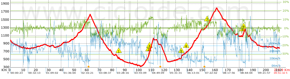
Distance in Km: 211.93
Climb in m: 3745
IBP: 262 BYC

Adam_Orozco_Vall
676 published routes

Add to my Group or Club

 Height in m      Climb in %      Speed in Km/h      Speed < 2 Km/h

Climbs > 5%

Climbs >5% Climbs >10% Climbs >15% Climbs >20% Climbs >25%
 Steep slope of 336 m.   Average slope  Distances  Download as waypoint
1
 Km 10.091  10%  336 m
 Steep slope of 157 m.  Average slope  Distances  Download as waypoint
2
 Km 13.233  7%  157 m
 Steep slope of 179 m.  Average slope  Distances  Download as waypoint
3
 Km 31.486  9%  179 m
 Steep slope of 369 m.  Average slope  Distances  Download as waypoint
4
 Km 40.253  6%  369 m
 Steep slope of 221 m.  Average slope  Distances  Download as waypoint
5
 Km 41.557  6%  221 m
 Steep slope of 261 m.  Average slope  Distances  Download as waypoint
6
 Km 46.978  6%  261 m
 Steep slope of 181 m.  Average slope  Distances  Download as waypoint
7
 Km 47.884  7%  181 m
 Steep slope of 140 m.  Average slope  Distances  Download as waypoint
8
 Km 50.245  6%  140 m
 Steep slope of 117 m.  Average slope  Distances  Download as waypoint
9
 Km 50.498  6%  117 m
 Steep slope of 145 m.  Average slope  Distances  Download as waypoint
10
 Km 51.435  5%  145 m
 Steep slope of 1027 m.  Average slope  Distances  Download as waypoint
11
 Km 52.381  7%  1027 m
 Steep slope of 142 m.  Average slope  Distances  Download as waypoint
12
 Km 54.694  5%  142 m
 Steep slope of 190 m.  Average slope  Distances  Download as waypoint
13
 Km 55.402  8%  190 m
 Steep slope of 177 m.  Average slope  Distances  Download as waypoint
14
 Km 56.125  6%  177 m
 Steep slope of 1959 m.  Average slope  Distances  Download as waypoint
15
 Km 56.757  8%  1959 m
 Steep slope of 555 m.  Average slope  Distances  Download as waypoint
16
 Km 59.073  7%  555 m
 Steep slope of 539 m.  Average slope  Distances  Download as waypoint
17
 Km 59.935  7%  539 m
 Steep slope of 414 m.  Average slope  Distances  Download as waypoint
18
 Km 60.729  7%  414 m
 Steep slope of 1527 m.  Average slope  Distances  Download as waypoint
19
 Km 61.261  7%  1527 m
 Steep slope of 109 m.  Average slope  Distances  Download as waypoint
20
 Km 72.768  6%  109 m
 Steep slope of 239 m.  Average slope  Distances  Download as waypoint
21
 Km 85.166  8%  121 m
22
 Km 85.287  14%  118 m
 Steep slope of 105 m.  Average slope  Distances  Download as waypoint
23
 Km 98.767  6%  105 m
 Steep slope of 142 m.  Average slope  Distances  Download as waypoint
24
 Km 100.178  6%  142 m
 Steep slope of 141 m.  Average slope  Distances  Download as waypoint
25
 Km 102.7  7%  141 m
 Steep slope of 133 m.  Average slope  Distances  Download as waypoint
26
 Km 104.305  6%  133 m
 Steep slope of 114 m.  Average slope  Distances  Download as waypoint
27
 Km 104.767  6%  114 m
 Steep slope of 254 m.  Average slope  Distances  Download as waypoint
28
 Km 105.501  5%  254 m
 Steep slope of 485 m.  Average slope  Distances  Download as waypoint
29
 Km 106.076  6%  485 m
 Steep slope of 210 m.  Average slope  Distances  Download as waypoint
30
 Km 106.727  7%  210 m
 Steep slope of 251 m.  Average slope  Distances  Download as waypoint
31
 Km 107.233  6%  251 m
 Steep slope of 4834 m.  Average slope  Distances  Download as waypoint
32
 Km 107.705  7%  913 m
33
 Km 108.618  11%  719 m
34
 Km 109.337  10%  98 m
35
 Km 109.436  12%  3061 m
36
 Km 112.497  6%  43 m
 Steep slope of 126 m.  Average slope  Distances  Download as waypoint
37
 Km 131.57  6%  126 m
 Steep slope of 654 m.  Average slope  Distances  Download as waypoint
38
 Km 134.18  7%  239 m
39
 Km 134.419  13%  415 m
 Steep slope of 139 m.  Average slope  Distances  Download as waypoint
40
 Km 138.367  12%  139 m
 Steep slope of 101 m.  Average slope  Distances  Download as waypoint
41
 Km 138.816  8%  101 m
 Steep slope of 131 m.  Average slope  Distances  Download as waypoint
42
 Km 139.246  6%  131 m
 Steep slope of 414 m.  Average slope  Distances  Download as waypoint
43
 Km 139.818  6%  414 m
 Steep slope of 234 m.  Average slope  Distances  Download as waypoint
44
 Km 141.035  7%  234 m
 Steep slope of 197 m.  Average slope  Distances  Download as waypoint
45
 Km 141.567  5%  197 m
 Steep slope of 228 m.  Average slope  Distances  Download as waypoint
46
 Km 141.96  6%  228 m
 Steep slope of 1183 m.  Average slope  Distances  Download as waypoint
47
 Km 142.637  7%  1183 m
 Steep slope of 759 m.  Average slope  Distances  Download as waypoint
48
 Km 144.14  8%  759 m
 Steep slope of 635 m.  Average slope  Distances  Download as waypoint
49
 Km 145.629  6%  635 m
 Steep slope of 113 m.  Average slope  Distances  Download as waypoint
50
 Km 146.386  5%  113 m
 Steep slope of 388 m.  Average slope  Distances  Download as waypoint
51
 Km 146.988  6%  388 m
 Steep slope of 794 m.  Average slope  Distances  Download as waypoint
52
 Km 147.49  8%  794 m
 Steep slope of 256 m.  Average slope  Distances  Download as waypoint
53
 Km 148.392  8%  256 m
 Steep slope of 340 m.  Average slope  Distances  Download as waypoint
54
 Km 148.769  7%  340 m
 Steep slope of 1124 m.  Average slope  Distances  Download as waypoint
55
 Km 149.313  7%  1124 m
 Steep slope of 142 m.  Average slope  Distances  Download as waypoint
56
 Km 152.795  6%  142 m
 Steep slope of 323 m.  Average slope  Distances  Download as waypoint
57
 Km 153.462  6%  323 m
 Steep slope of 187 m.  Average slope  Distances  Download as waypoint
58
 Km 154.664  11%  146 m
59
 Km 154.81  6%  41 m
 Steep slope of 140 m.  Average slope  Distances  Download as waypoint
60
 Km 155.442  12%  140 m
 Steep slope of 1286 m.  Average slope  Distances  Download as waypoint
61
 Km 156.068  8%  1286 m
 Steep slope of 1976 m.  Average slope  Distances  Download as waypoint
62
 Km 157.452  7%  1976 m
 Steep slope of 495 m.  Average slope  Distances  Download as waypoint
63
 Km 159.543  7%  495 m
 Steep slope of 1082 m.  Average slope  Distances  Download as waypoint
64
 Km 161.052  7%  1082 m
 Steep slope of 2139 m.  Average slope  Distances  Download as waypoint
65
 Km 182.612  7%  83 m
66
 Km 182.695  10%  187 m
67
 Km 182.882  9%  575 m
68
 Km 183.457  11%  100 m
69
 Km 183.557  8%  1194 m
 Steep slope of 429 m.  Average slope  Distances  Download as waypoint
70
 Km 187.464  6%  429 m
 Steep slope of 144 m.  Average slope  Distances  Download as waypoint
71
 Km 209.862  5%  144 m


Description of the route


Presence of ramps


 Climbs  Distance  % of the total  Speed  Your speed would be  Time  Your time would be
   15 - 30%  0.211  0.1  18.54  ?  0:00:41  ?
   10 - 15%  5.386  2.54  8.84  ?  0:36:33  ?
   5 - 10%  27.471  12.96  11.36  ?  2:25:02  ?
   1 - 5%  46.106  21.75  19.45  ?  2:22:15  ?
   Total*  79.175 Km  37.36 %  14.64 Km/h  ? Km/h    5:24:31 h  ? h  
 Flat
   1 - -1%  48.297 Km  22.79 %  28.33 Km/h  ? Km/h    1:42:17 h  ? h  
 Descents
   -1 - -5%  49.537  23.37  34.46  ?  1:26:15  ?
   -5 - -10%  30.981  14.62  40.9  ?  0:45:27  ?
   -10 - -15%  3.845  1.81  30.36  ?  0:07:36  ?
   -15 - -30%  0.1  0.05  32.84  ?  0:00:11  ?
   Total*  84.464 Km  39.85 %  36.33 Km/h  ? Km/h    2:19:29 h  ? h  
* The total has not necessarily coincide with the sum of the partials after correction of errors

How long would it take you?

How long would it take you to cover this route?
There are routes without a valid time information, but with your average stats you can assess the possible duration

Adam_Orozco_Vall to cover this route you've need a time of:   9:26:17 h 
If you sign in and have a minimum of two tracks of this same modality, you can know your time for this route, calculated from your stats..


¿Cuanto consumirá tu E-BIKE?

Entra tu E-IBP (formato n,nn)

E-IBP :   X 262 = 


 Detected activity type =  ()
 Penalization due to track conditions: 29 %   ( > 50 % = MTB, < 50 % = RDB)
 Reliability of the track: A   (3743/81/0/-/-/81)
 Correction level applied to the track: 0
DIFFICULTY OF THE ROUTE
IBP = 262 BYC
According to your statistics
 Your time in motion would be: ? h
Your average speed would be: ? Km/h
 

 Total Distance: 211.93 Km
 Analysed distance: 211.93 Km
 Linear distance: 10.78 Km

 Cumulated positive ramps: 3744.6 m  list of points info
 Cumulated negative ramps: 3938.9 m
 Maximum height: 1792.5 m
 Minimum height: 318.6 m
 Climbing Ratio: 4.73 %
 Descent ratio: 4.66 %
 Cumulated postive ramps per Km: 17.67 m
 Cumulated negative ramps per Km: 18.59 m

 Total time: 9:51:32 h
 Time in movement: 9:26:17 h
 According to your statistics
 Your time in motion would be: ? h  
 Stopped time: 0:25:15 h
 Maximum slope filter: ~30 %
 Minimum separation analysed: ~30 m
 Number of points: 8074   (cad. 26.25 m)
 Significant waypoints: 4611   (cad. 45.96 m / 57.11 %)

 Changes in direction per Km: 6.62
 Changes in direction > 5º por Km: 3.84
 Cumulated straight stretches: 74.828 Km
 Straight stretches per Km: 353.08 m
 Penalized slope changes: 23
 Penalized slope changes per Km: 0.109

 Average speed in total: 21.5 Km/h
 Average speed while moving: 22.45 Km/h
 According to your statistics
 Your average speed would be: ? Km/h  
 Maximum sustained speed: 65.9 Km/h


Comments

You can be the first one in commenting this route

 
My comments
:
Add comment  (Registered users)
 
Notify me answers to my comment  Do not notify answers to my comment


Share this route with a friend

Your friend will receive a message with a link to this page:
will see your email and your user name if you do it as registered user.


Write here your name (optional)

E-mail address of your friend(s). You can include various addresses separated by commas

Text or comment (optional) maximum 255 characters long, 255 Available characters

As a non registered users you need to fill-in the captcha text.
  Change image
Type the image characters.
 
 Share with a friend


Visited history

Delete history

Marked routes for review later or compare

My favorites


  Notify anomaly in this route Share in Facebook