Polientes, Mirador del Chivo, Polientes (vaya tostada _)

Road
Road
Ref..: 986352
Published: 15/08/2021
Performed: 14/08/2021
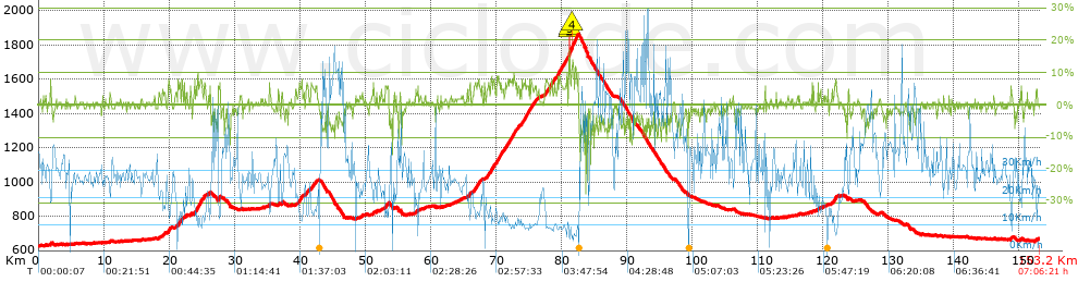
Distance in Km: 153.21
Climb in m: 1952
IBP: 147 BYC

Near ...
Arantiones, Campo De Ebro, Montecillo, Polientes, Quintanilla De An, Rebollar De Ebro
emilioea
Author: emilioea
178 published routes

Add to my Group or Club

 Height in m      Climb in %      Speed in Km/h      Speed < 2 Km/h

Climbs > 5%

Climbs >5% Climbs >10% Climbs >15% Climbs >20% Climbs >25%
 Steep slope of 289 m.   Average slope  Distances  Download as waypoint
1
 Km 19.857  7%  289 m
 Steep slope of 350 m.  Average slope  Distances  Download as waypoint
2
 Km 21.345  7%  350 m
 Steep slope of 210 m.  Average slope  Distances  Download as waypoint
3
 Km 21.874  7%  210 m
 Steep slope of 105 m.  Average slope  Distances  Download as waypoint
4
 Km 22.611  6%  105 m
 Steep slope of 249 m.  Average slope  Distances  Download as waypoint
5
 Km 23.92  6%  249 m
 Steep slope of 745 m.  Average slope  Distances  Download as waypoint
6
 Km 24.271  7%  745 m
 Steep slope of 144 m.  Average slope  Distances  Download as waypoint
7
 Km 25.357  6%  144 m
 Steep slope of 204 m.  Average slope  Distances  Download as waypoint
8
 Km 27.546  9%  204 m
 Steep slope of 111 m.  Average slope  Distances  Download as waypoint
9
 Km 35.266  8%  111 m
 Steep slope of 398 m.  Average slope  Distances  Download as waypoint
10
 Km 39.931  7%  398 m
 Steep slope of 302 m.  Average slope  Distances  Download as waypoint
11
 Km 40.965  6%  302 m
 Steep slope of 315 m.  Average slope  Distances  Download as waypoint
12
 Km 41.678  5%  315 m
 Steep slope of 123 m.  Average slope  Distances  Download as waypoint
13
 Km 42.376  5%  123 m
 Steep slope of 225 m.  Average slope  Distances  Download as waypoint
14
 Km 53.04  6%  225 m
 Steep slope of 106 m.  Average slope  Distances  Download as waypoint
15
 Km 53.414  5%  106 m
 Steep slope of 101 m.  Average slope  Distances  Download as waypoint
16
 Km 65.585  5%  101 m
 Steep slope of 219 m.  Average slope  Distances  Download as waypoint
17
 Km 65.879  7%  219 m
 Steep slope of 611 m.  Average slope  Distances  Download as waypoint
18
 Km 66.627  6%  611 m
 Steep slope of 224 m.  Average slope  Distances  Download as waypoint
19
 Km 67.34  6%  224 m
 Steep slope of 116 m.  Average slope  Distances  Download as waypoint
20
 Km 68.555  5%  116 m
 Steep slope of 245 m.  Average slope  Distances  Download as waypoint
21
 Km 68.777  6%  245 m
 Steep slope of 635 m.  Average slope  Distances  Download as waypoint
22
 Km 69.17  7%  635 m
 Steep slope of 922 m.  Average slope  Distances  Download as waypoint
23
 Km 70.055  7%  922 m
 Steep slope of 175 m.  Average slope  Distances  Download as waypoint
24
 Km 71.081  5%  175 m
 Steep slope of 270 m.  Average slope  Distances  Download as waypoint
25
 Km 71.357  6%  270 m
 Steep slope of 1102 m.  Average slope  Distances  Download as waypoint
26
 Km 71.728  7%  1102 m
 Steep slope of 108 m.  Average slope  Distances  Download as waypoint
27
 Km 73.123  6%  108 m
 Steep slope of 96 m.  Average slope  Distances  Download as waypoint
28
 Km 73.323  5%  96 m
 Steep slope of 705 m.  Average slope  Distances  Download as waypoint
29
 Km 73.86  6%  705 m
 Steep slope of 519 m.  Average slope  Distances  Download as waypoint
30
 Km 74.667  7%  519 m
 Steep slope of 316 m.  Average slope  Distances  Download as waypoint
31
 Km 75.29  7%  316 m
 Steep slope of 259 m.  Average slope  Distances  Download as waypoint
32
 Km 75.756  6%  259 m
 Steep slope of 150 m.  Average slope  Distances  Download as waypoint
33
 Km 76.126  5%  150 m
 Steep slope of 176 m.  Average slope  Distances  Download as waypoint
34
 Km 77.421  5%  176 m
 Steep slope of 109 m.  Average slope  Distances  Download as waypoint
35
 Km 77.721  6%  109 m
 Steep slope of 447 m.  Average slope  Distances  Download as waypoint
36
 Km 77.936  6%  447 m
 Steep slope of 175 m.  Average slope  Distances  Download as waypoint
37
 Km 78.486  7%  175 m
 Steep slope of 205 m.  Average slope  Distances  Download as waypoint
38
 Km 78.763  6%  205 m
 Steep slope of 239 m.  Average slope  Distances  Download as waypoint
39
 Km 79.257  7%  239 m
 Steep slope of 672 m.  Average slope  Distances  Download as waypoint
40
 Km 79.595  7%  672 m
 Steep slope of 587 m.  Average slope  Distances  Download as waypoint
41
 Km 80.377  7%  587 m
 Steep slope of 897 m.  Average slope  Distances  Download as waypoint
42
 Km 81.138  13%  36 m
43
 Km 81.174  16%  103 m
44
 Km 81.277  13%  66 m
45
 Km 81.344  6%  184 m
46
 Km 81.528  11%  168 m
47
 Km 81.696  8%  340 m
 Steep slope of 409 m.  Average slope  Distances  Download as waypoint
48
 Km 82.142  8%  409 m
 Steep slope of 297 m.  Average slope  Distances  Download as waypoint
49
 Km 121.715  7%  297 m
 Steep slope of 141 m.  Average slope  Distances  Download as waypoint
50
 Km 148.7  7%  141 m


Description of the route


Presence of ramps


 Climbs  Distance  % of the total  Speed  Your speed would be  Time  Your time would be
   15 - 30%  0.171  0.11  5.04  ?  0:02:02  ?
   10 - 15%  0.788  0.51  7.17  ?  0:06:36  ?
   5 - 10%  16.089  10.5  12.16  ?  1:19:24  ?
   1 - 5%  30.702  20.04  19.81  ?  1:32:59  ?
   Total*  47.75 Km  31.17 %  15.83 Km/h  ? Km/h    3:01:01 h  ? h  
 Flat
   1 - -1%  58.974 Km  38.49 %  29.18 Km/h  ? Km/h    2:01:16 h  ? h  
 Descents
   -1 - -5%  31.317  20.44  38.35  ?  0:49:00  ?
   -5 - -10%  13.685  8.93  51.43  ?  0:15:58  ?
   -10 - -15%  1.112  0.73  18.62  ?  0:03:35  ?
   -15 - -30%  0.376  0.25  31.47  ?  0:00:43  ?
   Total*  46.49 Km  30.34 %  40.27 Km/h  ? Km/h    1:09:16 h  ? h  
* The total has not necessarily coincide with the sum of the partials after correction of errors

How long would it take you?

How long would it take you to cover this route?
There are routes without a valid time information, but with your average stats you can assess the possible duration

emilioea to cover this route you've need a time of:   6:11:33 h 
If you sign in and have a minimum of two tracks of this same modality, you can know your time for this route, calculated from your stats..


¿Cuanto consumirá tu E-BIKE?

Entra tu E-IBP (formato n,nn)

E-IBP :   X 147 = 


 Detected activity type =  ()
 Penalization due to track conditions: 22 %   ( > 50 % = MTB, < 50 % = RDB)
 Reliability of the track: A   (1952/76/0/-/-/76)
 Correction level applied to the track: 0
DIFFICULTY OF THE ROUTE
IBP = 147 BYC
According to your statistics
 Your time in motion would be: ? h
Your average speed would be: ? Km/h
 

 Total Distance: 153.21 Km
 Analysed distance: 153.21 Km
 Linear distance: 0.75 Km

 Cumulated positive ramps: 1952.4 m  list of points info
 Cumulated negative ramps: 1920.2 m
 Maximum height: 1862 m
 Minimum height: 627 m
 Climbing Ratio: 4.09 %
 Descent ratio: 4.13 %
 Cumulated postive ramps per Km: 12.74 m
 Cumulated negative ramps per Km: 12.53 m

 Total time: 7:06:21 h
 Time in movement: 6:11:33 h
 According to your statistics
 Your time in motion would be: ? h  
 Stopped time: 0:54:48 h
 Maximum slope filter: ~30 %
 Minimum separation analysed: ~30 m
 Number of points: 10408   (cad. 14.72 m)
 Significant waypoints: 4234   (cad. 36.19 m / 40.68 %)

 Changes in direction per Km: 5.7
 Changes in direction > 5º por Km: 2.73
 Cumulated straight stretches: 68.385 Km
 Straight stretches per Km: 446.35 m
 Penalized slope changes: 16
 Penalized slope changes per Km: 0.104

 Average speed in total: 21.56 Km/h
 Average speed while moving: 24.74 Km/h
 According to your statistics
 Your average speed would be: ? Km/h  
 Maximum sustained speed: 76.72 Km/h


Comments

You can be the first one in commenting this route

 
My comments
:
Add comment  (Registered users)
 
Notify me answers to my comment  Do not notify answers to my comment


Share this route with a friend

Your friend will receive a message with a link to this page:
will see your email and your user name if you do it as registered user.


Write here your name (optional)

E-mail address of your friend(s). You can include various addresses separated by commas

Text or comment (optional) maximum 255 characters long, 255 Available characters

As a non registered users you need to fill-in the captcha text.
  Change image
Type the image characters.
 
 Share with a friend


Visited history

Delete history

Marked routes for review later or compare

My favorites


  Notify anomaly in this route Share in Facebook