Cercedilla, las Dehesas, Cercedilla

Hiking
Hiking
Ref..: 983665
Published: 05/08/2021
Performed: 04/08/2021
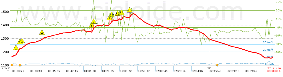
Distance in Km: 13.24
Climb in m: 456
IBP: 50 HKG

Near ...
Barrio Tablada, Cercedilla, Dehesas, Las, Sanatorio Tablada, Tablada (Apeadero)

 Height in m      Climb in %      Speed in Km/h      Speed < 2 Km/h

Climbs > 5%

Climbs >5% Climbs >10% Climbs >15% Climbs >20% Climbs >25%
 Steep slope of 909 m.   Average slope  Distances  Download as waypoint
1
 Km 0  8%  284 m
2
 Km 0.284  21%  166 m
3
 Km 0.45  22%  35 m
4
 Km 0.484  7%  129 m
5
 Km 0.613  12%  165 m
6
 Km 0.778  8%  130 m
 Steep slope of 297 m.  Average slope  Distances  Download as waypoint
7
 Km 1.399  7%  161 m
8
 Km 1.561  13%  99 m
9
 Km 1.66  7%  37 m
 Steep slope of 95 m.  Average slope  Distances  Download as waypoint
10
 Km 3.392  6%  95 m
 Steep slope of 233 m.  Average slope  Distances  Download as waypoint
11
 Km 4.037  13%  29 m
12
 Km 4.066  26%  130 m
13
 Km 4.196  17%  35 m
14
 Km 4.231  10%  39 m
 Steep slope of 97 m.  Average slope  Distances  Download as waypoint
15
 Km 4.593  10%  97 m
 Steep slope of 234 m.  Average slope  Distances  Download as waypoint
16
 Km 4.912  16%  38 m
17
 Km 4.95  22%  100 m
18
 Km 5.051  25%  35 m
19
 Km 5.085  17%  30 m
20
 Km 5.115  8%  31 m
 Steep slope of 32 m.  Average slope  Distances  Download as waypoint
21
 Km 5.416  10%  32 m
 Steep slope of 33 m.  Average slope  Distances  Download as waypoint
22
 Km 5.554  25%  33 m
 Steep slope of 200 m.  Average slope  Distances  Download as waypoint
23
 Km 5.918  11%  99 m
24
 Km 6.018  19%  101 m
 Steep slope of 166 m.  Average slope  Distances  Download as waypoint
25
 Km 8.22  7%  166 m
 Steep slope of 98 m.  Average slope  Distances  Download as waypoint
26
 Km 13.036  7%  98 m


Description of the route


Presence of ramps


 Climbs  Distance  % of the total  Speed  Your speed would be  Time  Your time would be
   15 - 30%  0.708  5.35  2.17  ?  0:19:37  ?
   10 - 15%  0.72  5.44  3.13  ?  0:13:48  ?
   5 - 10%  1.673  12.64  3.56  ?  0:28:10  ?
   1 - 5%  2.352  17.76  4.27  ?  0:33:04  ?
   Total*  5.554 Km  41.94 %  3.43 Km/h  ? Km/h    1:37:01 h  ? h  
 Flat
   1 - -1%  0.805 Km  6.08 %  4.31 Km/h  ? Km/h    0:11:12 h  ? h  
 Descents
   -1 - -5%  2.954  22.31  4.71  ?  0:37:37  ?
   -5 - -10%  2.862  21.61  4.54  ?  0:37:52  ?
   -10 - -15%  0.681  5.14  4.27  ?  0:09:34  ?
   -15 - -30%  0.386  2.92  3.48  ?  0:06:40  ?
   Total*  6.884 Km  51.98 %  4.5 Km/h  ? Km/h    1:31:43 h  ? h  
* The total has not necessarily coincide with the sum of the partials after correction of errors

How long would it take you?

How long would it take you to cover this route?
There are routes without a valid time information, but with your average stats you can assess the possible duration

miguel ángel méndez to cover this route you've need a time of:   3:19:56 h 
If you sign in and have a minimum of two tracks of this same modality, you can know your time for this route, calculated from your stats..


 Detected activity type =  ()
 Penalization due to track conditions: 0 %   ( > 50 % = MTB, < 50 % = RDB)
 Reliability of the track: B   (456/62/0/-/-/62)
 Correction level applied to the track: 0
DIFFICULTY OF THE ROUTE
IBP = 50 HKG
According to your statistics
 Your time in motion would be: ? h
Your average speed would be: ? Km/h
 

 Total Distance: 13.24 Km
 Analysed distance: 13.24 Km
 Linear distance: 0.06 Km

 Cumulated positive ramps: 456 m  list of points info
 Cumulated negative ramps: 451.3 m
 Maximum height: 1487.3 m
 Minimum height: 1152.9 m
 Climbing Ratio: 8.21 %
 Descent ratio: 6.56 %
 Cumulated postive ramps per Km: 34.44 m
 Cumulated negative ramps per Km: 34.09 m

 Total time: 3:31:09 h
 Time in movement: 3:19:56 h
 According to your statistics
 Your time in motion would be: ? h  
 Stopped time: 0:11:13 h
 Maximum slope filter: ~55 %
 Minimum separation analysed: ~30 m
 Number of points: 1278   (cad. 10.36 m)
 Significant waypoints: 406   (cad. 32.62 m / 31.77 %)

 Changes in direction per Km: 15.33
 Changes in direction > 5º por Km: 12.16
 Cumulated straight stretches: 1.349 Km
 Straight stretches per Km: 101.89 m
 Penalized slope changes: 1
 Penalized slope changes per Km: 0.076

 Average speed in total: 3.76 Km/h
 Average speed while moving: 3.97 Km/h
 According to your statistics
 Your average speed would be: ? Km/h  
 Maximum sustained speed: 7.29 Km/h


Comments

You can be the first one in commenting this route

 
My comments
:
Add comment  (Registered users)
 
Notify me answers to my comment  Do not notify answers to my comment


Share this route with a friend

Your friend will receive a message with a link to this page:
will see your email and your user name if you do it as registered user.


Write here your name (optional)

E-mail address of your friend(s). You can include various addresses separated by commas

Text or comment (optional) maximum 255 characters long, 255 Available characters

As a non registered users you need to fill-in the captcha text.
  Change image
Type the image characters.
 
 Share with a friend


Visited history

Delete history

Marked routes for review later or compare

My favorites


  Notify anomaly in this route Share in Facebook