Puigmal d'Err i algún error

MTB
MTB
Ref..: 977616
Published: 14/07/2021
Performed: 13/07/2021
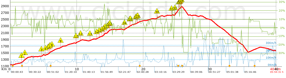
Distance in Km: 40.04
Climb in m: 2162
IBP: 186 BYC

silvesterbike
396 published routes

Add to my Group or Club

 Height in m      Climb in %      Speed in Km/h      Speed < 2 Km/h

Climbs > 5%

Climbs >5% Climbs >10% Climbs >15% Climbs >20% Climbs >25%
 Steep slope of 1241 m.   Average slope  Distances  Download as waypoint
1
 Km 1.375  6%  299 m
2
 Km 1.674  17%  522 m
3
 Km 2.196  15%  420 m
 Steep slope of 180 m.  Average slope  Distances  Download as waypoint
4
 Km 3.052  9%  180 m
 Steep slope of 98 m.  Average slope  Distances  Download as waypoint
5
 Km 3.504  8%  98 m
 Steep slope of 338 m.  Average slope  Distances  Download as waypoint
6
 Km 4.639  9%  40 m
7
 Km 4.679  16%  265 m
8
 Km 4.944  12%  33 m
 Steep slope of 160 m.  Average slope  Distances  Download as waypoint
9
 Km 5.246  7%  51 m
10
 Km 5.297  13%  109 m
 Steep slope of 1281 m.  Average slope  Distances  Download as waypoint
11
 Km 5.517  8%  161 m
12
 Km 5.679  17%  186 m
13
 Km 5.865  20%  84 m
14
 Km 5.949  9%  34 m
15
 Km 5.983  15%  133 m
16
 Km 6.116  7%  143 m
17
 Km 6.259  12%  464 m
18
 Km 6.723  10%  76 m
 Steep slope of 211 m.  Average slope  Distances  Download as waypoint
19
 Km 6.927  6%  211 m
 Steep slope of 640 m.  Average slope  Distances  Download as waypoint
20
 Km 7.305  9%  270 m
21
 Km 7.575  13%  267 m
22
 Km 7.842  6%  103 m
 Steep slope of 695 m.  Average slope  Distances  Download as waypoint
23
 Km 8.263  8%  695 m
 Steep slope of 340 m.  Average slope  Distances  Download as waypoint
24
 Km 9.172  6%  340 m
 Steep slope of 971 m.  Average slope  Distances  Download as waypoint
25
 Km 9.819  8%  32 m
26
 Km 9.851  13%  36 m
27
 Km 9.887  16%  96 m
28
 Km 9.982  9%  80 m
29
 Km 10.062  9%  484 m
30
 Km 10.546  12%  138 m
31
 Km 10.683  7%  105 m
 Steep slope of 634 m.  Average slope  Distances  Download as waypoint
32
 Km 11.938  11%  138 m
33
 Km 12.076  9%  496 m
 Steep slope of 695 m.  Average slope  Distances  Download as waypoint
34
 Km 12.924  5%  34 m
35
 Km 12.958  11%  254 m
36
 Km 13.212  9%  156 m
37
 Km 13.368  12%  179 m
38
 Km 13.546  9%  72 m
 Steep slope of 579 m.  Average slope  Distances  Download as waypoint
39
 Km 13.761  13%  281 m
40
 Km 14.042  24%  176 m
41
 Km 14.218  17%  39 m
42
 Km 14.257  18%  39 m
43
 Km 14.296  7%  44 m
 Steep slope of 698 m.  Average slope  Distances  Download as waypoint
44
 Km 14.483  6%  29 m
45
 Km 14.512  17%  77 m
46
 Km 14.589  21%  249 m
47
 Km 14.838  20%  84 m
48
 Km 14.923  16%  32 m
49
 Km 14.954  7%  227 m
 Steep slope of 132 m.  Average slope  Distances  Download as waypoint
50
 Km 15.411  6%  132 m
 Steep slope of 1311 m.  Average slope  Distances  Download as waypoint
51
 Km 17.127  6%  40 m
52
 Km 17.167  13%  804 m
53
 Km 17.971  12%  108 m
54
 Km 18.079  12%  294 m
55
 Km 18.373  6%  65 m
 Steep slope of 1244 m.  Average slope  Distances  Download as waypoint
56
 Km 18.637  6%  256 m
57
 Km 18.894  10%  211 m
58
 Km 19.105  10%  110 m
59
 Km 19.215  11%  187 m
60
 Km 19.401  7%  480 m
 Steep slope of 237 m.  Average slope  Distances  Download as waypoint
61
 Km 20.489  5%  237 m
 Steep slope of 349 m.  Average slope  Distances  Download as waypoint
62
 Km 20.941  9%  349 m
 Steep slope of 715 m.  Average slope  Distances  Download as waypoint
63
 Km 21.897  6%  127 m
64
 Km 22.024  13%  545 m
65
 Km 22.569  6%  43 m
 Steep slope of 458 m.  Average slope  Distances  Download as waypoint
66
 Km 23.156  7%  458 m
 Steep slope of 32 m.  Average slope  Distances  Download as waypoint
67
 Km 24.302  17%  32 m
 Steep slope of 1108 m.  Average slope  Distances  Download as waypoint
68
 Km 24.682  6%  47 m
69
 Km 24.729  28%  616 m
70
 Km 25.345  23%  35 m
71
 Km 25.38  16%  38 m
72
 Km 25.418  11%  106 m
73
 Km 25.524  28%  128 m
74
 Km 25.652  13%  37 m
75
 Km 25.689  19%  35 m
76
 Km 25.724  23%  35 m
77
 Km 25.759  15%  31 m
 Steep slope of 103 m.  Average slope  Distances  Download as waypoint
78
 Km 26.877  12%  103 m
 Steep slope of 254 m.  Average slope  Distances  Download as waypoint
79
 Km 28.352  7%  254 m
 Steep slope of 1722 m.  Average slope  Distances  Download as waypoint
80
 Km 35.788  9%  1722 m
 Steep slope of 119 m.  Average slope  Distances  Download as waypoint
81
 Km 39.707  7%  119 m


Description of the route


Presence of ramps


 Climbs  Distance  % of the total  Speed  Your speed would be  Time  Your time would be
   15 - 30%  3.079  7.69  5.57  ?  0:33:12  ?
   10 - 15%  5.519  13.78  7.15  ?  0:46:17  ?
   5 - 10%  8.908  22.25  8.67  ?  1:01:38  ?
   1 - 5%  5.321  13.29  8.93  ?  0:35:46  ?
   Total*  22.827 Km  57.01 %  7.74 Km/h  ? Km/h    2:56:53 h  ? h  
 Flat
   1 - -1%  1.777 Km  4.44 %  11.71 Km/h  ? Km/h    0:09:06 h  ? h  
 Descents
   -1 - -5%  4.763  11.89  12.8  ?  0:22:20  ?
   -5 - -10%  3.297  8.23  18.69  ?  0:10:35  ?
   -10 - -15%  2.489  6.22  15.11  ?  0:09:53  ?
   -15 - -30%  4.889  12.21  11.58  ?  0:25:20  ?
   Total*  15.438 Km  38.56 %  13.6 Km/h  ? Km/h    1:08:08 h  ? h  
* The total has not necessarily coincide with the sum of the partials after correction of errors

How long would it take you?

How long would it take you to cover this route?
There are routes without a valid time information, but with your average stats you can assess the possible duration

silvesterbike to cover this route you've need a time of:   4:14:07 h 
If you sign in and have a minimum of two tracks of this same modality, you can know your time for this route, calculated from your stats..


¿Cuanto consumirá tu E-BIKE?

Entra tu E-IBP (formato n,nn)

E-IBP :   X 186 = 


 Detected activity type =  ()
 Penalization due to track conditions: 71 %   ( > 50 % = MTB, < 50 % = RDB)
 Reliability of the track: A   (2162/85/0/-/-/85)
 Correction level applied to the track: 0
DIFFICULTY OF THE ROUTE
IBP = 186 BYC
According to your statistics
 Your time in motion would be: ? h
Your average speed would be: ? Km/h
 

 Total Distance: 40.04 Km
 Analysed distance: 40.04 Km
 Linear distance: 3.61 Km

 Cumulated positive ramps: 2161.6 m  list of points info
 Cumulated negative ramps: 1740 m
 Maximum height: 2888.2 m
 Minimum height: 1145.1 m
 Climbing Ratio: 9.47 %
 Descent ratio: 11.27 %
 Cumulated postive ramps per Km: 53.99 m
 Cumulated negative ramps per Km: 43.46 m

 Total time: 5:54:31 h
 Time in movement: 4:14:07 h
 According to your statistics
 Your time in motion would be: ? h  
 Stopped time: 1:40:24 h
 Maximum slope filter: ~30 %
 Minimum separation analysed: ~30 m
 Number of points: 2336   (cad. 17.14 m)
 Significant waypoints: 1035   (cad. 38.69 m / 44.31 %)

 Changes in direction per Km: 11.01
 Changes in direction > 5º por Km: 7.52
 Cumulated straight stretches: 5.383 Km
 Straight stretches per Km: 134.44 m
 Penalized slope changes: 16
 Penalized slope changes per Km: 0.4

 Average speed in total: 6.78 Km/h
 Average speed while moving: 9.45 Km/h
 According to your statistics
 Your average speed would be: ? Km/h  
 Maximum sustained speed: 47.17 Km/h


Comments

You can be the first one in commenting this route

 
My comments
:
Add comment  (Registered users)
 
Notify me answers to my comment  Do not notify answers to my comment


Share this route with a friend

Your friend will receive a message with a link to this page:
will see your email and your user name if you do it as registered user.


Write here your name (optional)

E-mail address of your friend(s). You can include various addresses separated by commas

Text or comment (optional) maximum 255 characters long, 255 Available characters

As a non registered users you need to fill-in the captcha text.
  Change image
Type the image characters.
 
 Share with a friend


Visited history

Delete history

Marked routes for review later or compare

My favorites


  Notify anomaly in this route Share in Facebook