26^Dolomiti Superbike 2021

MTB
MTB
Ref..: 976805
Published: 11/07/2021
Performed: 10/07/2021
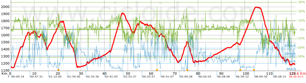
Distance in Km: 121.63
Climb in m: 3576
IBP: 248 BYC

Beppe Cavalli
569 published routes

Add to my Group or Club

 Height in m      Climb in %      Speed in Km/h      Speed < 2 Km/h

Climbs > 5%

Climbs >5% Climbs >10% Climbs >15% Climbs >20% Climbs >25%
 Steep slope of 2841 m.   Average slope  Distances  Download as waypoint
1
 Km 1.274  9%  331 m
2
 Km 1.605  10%  97 m
3
 Km 1.702  9%  195 m
4
 Km 1.897  11%  301 m
5
 Km 2.198  9%  531 m
6
 Km 2.729  11%  98 m
7
 Km 2.827  9%  100 m
8
 Km 2.927  11%  131 m
9
 Km 3.058  9%  162 m
10
 Km 3.219  11%  199 m
11
 Km 3.418  10%  137 m
12
 Km 3.555  10%  102 m
13
 Km 3.657  10%  127 m
14
 Km 3.784  10%  230 m
15
 Km 4.013  9%  100 m
 Steep slope of 108 m.  Average slope  Distances  Download as waypoint
16
 Km 4.288  7%  108 m
 Steep slope of 1526 m.  Average slope  Distances  Download as waypoint
17
 Km 5.04  9%  172 m
18
 Km 5.212  13%  291 m
19
 Km 5.503  9%  99 m
20
 Km 5.602  11%  129 m
21
 Km 5.731  9%  100 m
22
 Km 5.831  12%  95 m
23
 Km 5.926  5%  102 m
24
 Km 6.028  11%  261 m
25
 Km 6.289  8%  277 m
 Steep slope of 330 m.  Average slope  Distances  Download as waypoint
26
 Km 6.895  10%  134 m
27
 Km 7.029  10%  196 m
 Steep slope of 284 m.  Average slope  Distances  Download as waypoint
28
 Km 8.194  6%  284 m
 Steep slope of 299 m.  Average slope  Distances  Download as waypoint
29
 Km 9.481  8%  36 m
30
 Km 9.517  11%  101 m
31
 Km 9.618  11%  162 m
 Steep slope of 515 m.  Average slope  Distances  Download as waypoint
32
 Km 12.243  8%  515 m
 Steep slope of 459 m.  Average slope  Distances  Download as waypoint
33
 Km 15.6  12%  391 m
34
 Km 15.991  10%  68 m
 Steep slope of 104 m.  Average slope  Distances  Download as waypoint
35
 Km 16.444  11%  104 m
 Steep slope of 776 m.  Average slope  Distances  Download as waypoint
36
 Km 16.816  7%  776 m
 Steep slope of 666 m.  Average slope  Distances  Download as waypoint
37
 Km 17.693  9%  166 m
38
 Km 17.86  10%  99 m
39
 Km 17.959  9%  169 m
40
 Km 18.127  10%  133 m
41
 Km 18.26  11%  99 m
 Steep slope of 174 m.  Average slope  Distances  Download as waypoint
42
 Km 18.537  7%  174 m
 Steep slope of 104 m.  Average slope  Distances  Download as waypoint
43
 Km 18.89  5%  104 m
 Steep slope of 532 m.  Average slope  Distances  Download as waypoint
44
 Km 19.098  7%  204 m
45
 Km 19.302  15%  165 m
46
 Km 19.467  7%  163 m
 Steep slope of 607 m.  Average slope  Distances  Download as waypoint
47
 Km 20.017  7%  308 m
48
 Km 20.325  13%  232 m
49
 Km 20.557  12%  67 m
 Steep slope of 172 m.  Average slope  Distances  Download as waypoint
50
 Km 20.931  8%  172 m
 Steep slope of 106 m.  Average slope  Distances  Download as waypoint
51
 Km 21.967  9%  106 m
 Steep slope of 167 m.  Average slope  Distances  Download as waypoint
52
 Km 28.532  7%  167 m
 Steep slope of 322 m.  Average slope  Distances  Download as waypoint
53
 Km 32.339  6%  37 m
54
 Km 32.376  14%  191 m
55
 Km 32.568  5%  94 m
 Steep slope of 101 m.  Average slope  Distances  Download as waypoint
56
 Km 34.925  6%  101 m
 Steep slope of 132 m.  Average slope  Distances  Download as waypoint
57
 Km 35.129  5%  132 m
 Steep slope of 218 m.  Average slope  Distances  Download as waypoint
58
 Km 37.061  6%  218 m
 Steep slope of 99 m.  Average slope  Distances  Download as waypoint
59
 Km 42.123  9%  99 m
 Steep slope of 3241 m.  Average slope  Distances  Download as waypoint
60
 Km 42.52  9%  561 m
61
 Km 43.082  13%  387 m
62
 Km 43.468  9%  201 m
63
 Km 43.67  9%  97 m
64
 Km 43.766  12%  99 m
65
 Km 43.865  13%  515 m
66
 Km 44.38  9%  194 m
67
 Km 44.574  13%  386 m
68
 Km 44.96  9%  130 m
69
 Km 45.091  10%  96 m
70
 Km 45.187  9%  127 m
71
 Km 45.314  13%  287 m
72
 Km 45.602  12%  161 m
 Steep slope of 1425 m.  Average slope  Distances  Download as waypoint
73
 Km 45.862  6%  34 m
74
 Km 45.895  17%  93 m
75
 Km 45.988  13%  288 m
76
 Km 46.276  8%  129 m
77
 Km 46.405  10%  213 m
78
 Km 46.618  14%  95 m
79
 Km 46.712  11%  154 m
80
 Km 46.867  13%  325 m
81
 Km 47.192  12%  94 m
 Steep slope of 102 m.  Average slope  Distances  Download as waypoint
82
 Km 47.587  8%  102 m
 Steep slope of 166 m.  Average slope  Distances  Download as waypoint
83
 Km 52.251  14%  133 m
84
 Km 52.384  7%  33 m
 Steep slope of 977 m.  Average slope  Distances  Download as waypoint
85
 Km 52.768  11%  129 m
86
 Km 52.897  9%  162 m
87
 Km 53.059  12%  131 m
88
 Km 53.19  8%  131 m
89
 Km 53.321  11%  96 m
90
 Km 53.418  7%  231 m
91
 Km 53.648  13%  97 m
 Steep slope of 296 m.  Average slope  Distances  Download as waypoint
92
 Km 53.812  5%  33 m
93
 Km 53.846  8%  197 m
94
 Km 54.043  12%  66 m
 Steep slope of 332 m.  Average slope  Distances  Download as waypoint
95
 Km 54.575  9%  136 m
96
 Km 54.71  12%  98 m
97
 Km 54.809  10%  98 m
 Steep slope of 131 m.  Average slope  Distances  Download as waypoint
98
 Km 55.006  7%  33 m
99
 Km 55.039  15%  98 m
 Steep slope of 134 m.  Average slope  Distances  Download as waypoint
100
 Km 63.395  10%  134 m
 Steep slope of 102 m.  Average slope  Distances  Download as waypoint
101
 Km 63.966  7%  102 m
 Steep slope of 131 m.  Average slope  Distances  Download as waypoint
102
 Km 68.028  7%  131 m
 Steep slope of 107 m.  Average slope  Distances  Download as waypoint
103
 Km 71.652  5%  107 m
 Steep slope of 1646 m.  Average slope  Distances  Download as waypoint
104
 Km 72.69  8%  323 m
105
 Km 73.013  13%  256 m
106
 Km 73.27  9%  297 m
107
 Km 73.567  9%  99 m
108
 Km 73.666  18%  96 m
109
 Km 73.762  12%  224 m
110
 Km 73.986  10%  98 m
111
 Km 74.084  12%  221 m
112
 Km 74.305  11%  32 m
 Steep slope of 101 m.  Average slope  Distances  Download as waypoint
113
 Km 74.62  7%  101 m
 Steep slope of 438 m.  Average slope  Distances  Download as waypoint
114
 Km 74.831  15%  32 m
115
 Km 74.863  14%  95 m
116
 Km 74.958  14%  155 m
117
 Km 75.112  19%  94 m
118
 Km 75.206  13%  62 m
 Steep slope of 346 m.  Average slope  Distances  Download as waypoint
119
 Km 78.466  8%  346 m
 Steep slope of 138 m.  Average slope  Distances  Download as waypoint
120
 Km 80.054  8%  138 m
 Steep slope of 104 m.  Average slope  Distances  Download as waypoint
121
 Km 94.639  5%  104 m
 Steep slope of 398 m.  Average slope  Distances  Download as waypoint
122
 Km 98.019  9%  398 m
 Steep slope of 661 m.  Average slope  Distances  Download as waypoint
123
 Km 98.517  9%  499 m
124
 Km 99.016  10%  98 m
125
 Km 99.114  9%  64 m
 Steep slope of 1420 m.  Average slope  Distances  Download as waypoint
126
 Km 99.279  8%  861 m
127
 Km 100.139  10%  101 m
128
 Km 100.24  8%  458 m
 Steep slope of 3088 m.  Average slope  Distances  Download as waypoint
129
 Km 100.792  9%  899 m
130
 Km 101.691  10%  96 m
131
 Km 101.788  9%  1638 m
132
 Km 103.425  10%  98 m
133
 Km 103.523  8%  357 m
 Steep slope of 369 m.  Average slope  Distances  Download as waypoint
134
 Km 103.976  7%  369 m
 Steep slope of 164 m.  Average slope  Distances  Download as waypoint
135
 Km 113.286  18%  98 m
136
 Km 113.384  7%  66 m
 Steep slope of 180 m.  Average slope  Distances  Download as waypoint
137
 Km 116.196  9%  180 m
 Steep slope of 139 m.  Average slope  Distances  Download as waypoint
138
 Km 117.478  10%  139 m
 Steep slope of 243 m.  Average slope  Distances  Download as waypoint
139
 Km 120.096  5%  243 m


Description of the route


Presence of ramps


 Climbs  Distance  % of the total  Speed  Your speed would be  Time  Your time would be
   15 - 30%  1.699  1.4  5.05  ?  0:20:12  ?
   10 - 15%  9.549  7.85  6.01  ?  1:35:17  ?
   5 - 10%  19.483  16.02  8.19  ?  2:22:42  ?
   1 - 5%  25.292  20.79  14.92  ?  1:41:43  ?
   Total*  56.024 Km  46.06 %  9.34 Km/h  ? Km/h    5:59:54 h  ? h  
 Flat
   1 - -1%  20.662 Km  16.99 %  22.53 Km/h  ? Km/h    0:55:02 h  ? h  
 Descents
   -1 - -5%  16.885  13.88  29.28  ?  0:34:36  ?
   -5 - -10%  14.078  11.57  35.74  ?  0:23:38  ?
   -10 - -15%  8.823  7.25  33.72  ?  0:15:42  ?
   -15 - -30%  5.161  4.24  27.2  ?  0:11:23  ?
   Total*  44.947 Km  36.95 %  31.61 Km/h  ? Km/h    1:25:19 h  ? h  
* The total has not necessarily coincide with the sum of the partials after correction of errors

How long would it take you?

How long would it take you to cover this route?
There are routes without a valid time information, but with your average stats you can assess the possible duration

Beppe Cavalli to cover this route you've need a time of:   8:20:15 h 
If you sign in and have a minimum of two tracks of this same modality, you can know your time for this route, calculated from your stats..


¿Cuanto consumirá tu E-BIKE?

Entra tu E-IBP (formato n,nn)

E-IBP :   X 248 = 


 Detected activity type =  ()
 Penalization due to track conditions: 60 %   ( > 50 % = MTB, < 50 % = RDB)
 Reliability of the track: A   (3580/80/0/-/-/80)
 Correction level applied to the track: 0
DIFFICULTY OF THE ROUTE
IBP = 248 BYC
According to your statistics
 Your time in motion would be: ? h
Your average speed would be: ? Km/h
 

 Total Distance: 121.63 Km
 Analysed distance: 121.63 Km
 Linear distance: 0.11 Km

 Cumulated positive ramps: 3575.6 m  list of points info
 Cumulated negative ramps: 3562.8 m
 Maximum height: 1998.2 m
 Minimum height: 1141 m
 Climbing Ratio: 6.38 %
 Descent ratio: 7.93 %
 Cumulated postive ramps per Km: 29.4 m
 Cumulated negative ramps per Km: 29.29 m

 Total time: 8:50:53 h
 Time in movement: 8:20:15 h
 According to your statistics
 Your time in motion would be: ? h  
 Stopped time: 0:30:38 h
 Maximum slope filter: ~30 %
 Minimum separation analysed: ~30 m
 Number of points: 9607   (cad. 12.66 m)
 Significant waypoints: 3443   (cad. 35.33 m / 35.84 %)

 Changes in direction per Km: 12.05
 Changes in direction > 5º por Km: 8.32
 Cumulated straight stretches: 24.306 Km
 Straight stretches per Km: 199.84 m
 Penalized slope changes: 28
 Penalized slope changes per Km: 0.23

 Average speed in total: 13.75 Km/h
 Average speed while moving: 14.59 Km/h
 According to your statistics
 Your average speed would be: ? Km/h  
 Maximum sustained speed: 69.9 Km/h


Comments

You can be the first one in commenting this route

 
My comments
:
Add comment  (Registered users)
 
Notify me answers to my comment  Do not notify answers to my comment


Share this route with a friend

Your friend will receive a message with a link to this page:
will see your email and your user name if you do it as registered user.


Write here your name (optional)

E-mail address of your friend(s). You can include various addresses separated by commas

Text or comment (optional) maximum 255 characters long, 255 Available characters

As a non registered users you need to fill-in the captcha text.
  Change image
Type the image characters.
 
 Share with a friend


Visited history

Delete history

Marked routes for review later or compare

My favorites


  Notify anomaly in this route Share in Facebook