__ Track_ ____ Track___T_ mi basta _

MTB
MTB
Ref..: 966887
Published: 03/06/2021
Performed: 02/06/2021
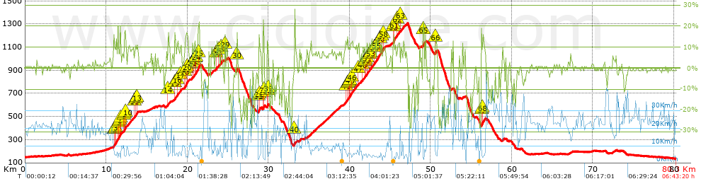
Distance in Km: 80.3
Climb in m: 2535
IBP: 191 BYC

Beppe Cavalli
569 published routes

Add to my Group or Club

 Height in m      Climb in %      Speed in Km/h      Speed < 2 Km/h

Climbs > 10%

Climbs >5% Climbs >10% Climbs >15% Climbs >20% Climbs >25%
 Steep slope of 1529 m.   Average slope  Distances  Download as waypoint
1
 Km 10.946  11%  134 m
2
 Km 11.079  10%  130 m
3
 Km 11.21  14%  264 m
4
 Km 11.474  11%  96 m
5
 Km 11.57  11%  138 m
6
 Km 11.708  18%  72 m
7
 Km 11.779  21%  31 m
8
 Km 12.194  11%  35 m
9
 Km 12.228  16%  131 m
10
 Km 12.36  13%  133 m
11
 Km 13.509  10%  134 m
12
 Km 13.642  11%  135 m
13
 Km 13.777  10%  104 m
 Steep slope of 138 m.  Average slope  Distances  Download as waypoint
14
 Km 17.616  14%  138 m
 Steep slope of 461 m.  Average slope  Distances  Download as waypoint
15
 Km 18.438  13%  199 m
16
 Km 18.732  12%  164 m
17
 Km 19.171  11%  98 m
 Steep slope of 400 m.  Average slope  Distances  Download as waypoint
18
 Km 19.694  13%  138 m
19
 Km 19.832  15%  98 m
20
 Km 19.93  15%  164 m
 Steep slope of 660 m.  Average slope  Distances  Download as waypoint
21
 Km 20.582  12%  97 m
22
 Km 20.778  10%  165 m
23
 Km 20.944  13%  34 m
24
 Km 21.077  16%  103 m
25
 Km 21.349  20%  129 m
 Steep slope of 383 m.  Average slope  Distances  Download as waypoint
26
 Km 23.568  15%  94 m
27
 Km 23.831  12%  97 m
28
 Km 24.13  14%  192 m
 Steep slope of 140 m.  Average slope  Distances  Download as waypoint
29
 Km 24.644  10%  140 m
 Steep slope of 132 m.  Average slope  Distances  Download as waypoint
30
 Km 26.061  16%  132 m
 Steep slope of 192 m.  Average slope  Distances  Download as waypoint
31
 Km 28.785  14%  32 m
32
 Km 28.817  17%  96 m
33
 Km 28.913  15%  64 m
 Steep slope of 198 m.  Average slope  Distances  Download as waypoint
34
 Km 29.333  23%  103 m
35
 Km 29.436  16%  63 m
36
 Km 29.498  17%  32 m
 Steep slope of 159 m.  Average slope  Distances  Download as waypoint
37
 Km 29.818  13%  32 m
38
 Km 29.851  20%  95 m
39
 Km 29.946  11%  32 m
 Steep slope of 2236 m.  Average slope  Distances  Download as waypoint
40
 Km 33.212  17%  132 m
41
 Km 39.539  11%  191 m
42
 Km 39.73  10%  130 m
43
 Km 39.86  10%  94 m
44
 Km 39.954  10%  97 m
45
 Km 40.051  12%  194 m
46
 Km 40.246  10%  561 m
47
 Km 41.034  13%  129 m
48
 Km 41.56  11%  99 m
49
 Km 41.821  10%  97 m
50
 Km 42.01  10%  192 m
51
 Km 42.202  10%  241 m
52
 Km 42.443  11%  160 m
53
 Km 42.603  10%  458 m
54
 Km 43.06  12%  131 m
55
 Km 43.286  13%  363 m
56
 Km 43.746  11%  226 m
57
 Km 43.973  10%  203 m
58
 Km 44.176  12%  131 m
 Steep slope of 550 m.  Average slope  Distances  Download as waypoint
59
 Km 45.356  14%  32 m
60
 Km 45.388  18%  130 m
61
 Km 45.518  12%  134 m
62
 Km 45.879  11%  99 m
63
 Km 46.301  11%  155 m
 Steep slope of 159 m.  Average slope  Distances  Download as waypoint
64
 Km 49.046  17%  65 m
65
 Km 49.112  22%  94 m
 Steep slope of 165 m.  Average slope  Distances  Download as waypoint
66
 Km 50.614  13%  165 m
 Steep slope of 465 m.  Average slope  Distances  Download as waypoint
67
 Km 56.232  15%  166 m
68
 Km 56.398  13%  299 m


Description of the route


Presence of ramps


 Climbs  Distance  % of the total  Speed  Your speed would be  Time  Your time would be
   15 - 30%  2.181  2.72  4.74  ?  0:27:38  ?
   10 - 15%  6.768  8.43  5.94  ?  1:08:19  ?
   5 - 10%  12.925  16.09  8.39  ?  1:32:29  ?
   1 - 5%  13.532  16.85  15.02  ?  0:54:04  ?
   Total*  35.406 Km  44.09 %  8.76 Km/h  ? Km/h    4:02:30 h  ? h  
 Flat
   1 - -1%  20.26 Km  25.23 %  22.35 Km/h  ? Km/h    0:54:23 h  ? h  
 Descents
   -1 - -5%  8.812  10.97  23.46  ?  0:22:32  ?
   -5 - -10%  4.834  6.02  20.55  ?  0:14:07  ?
   -10 - -15%  3.869  4.82  21.37  ?  0:10:52  ?
   -15 - -30%  7.147  8.9  12.34  ?  0:34:45  ?
   Total*  24.663 Km  30.71 %  17.99 Km/h  ? Km/h    1:22:16 h  ? h  
* The total has not necessarily coincide with the sum of the partials after correction of errors

How long would it take you?

How long would it take you to cover this route?
There are routes without a valid time information, but with your average stats you can assess the possible duration

Beppe Cavalli to cover this route you've need a time of:   6:19:09 h 
If you sign in and have a minimum of two tracks of this same modality, you can know your time for this route, calculated from your stats..


¿Cuanto consumirá tu E-BIKE?

Entra tu E-IBP (formato n,nn)

E-IBP :   X 191 = 


 Detected activity type =  ()
 Penalization due to track conditions: 61 %   ( > 50 % = MTB, < 50 % = RDB)
 Reliability of the track: A   (2537/77/0/-/-/77)
 Correction level applied to the track: 0
DIFFICULTY OF THE ROUTE
IBP = 191 BYC
According to your statistics
 Your time in motion would be: ? h
Your average speed would be: ? Km/h
 

 Total Distance: 80.3 Km
 Analysed distance: 80.3 Km
 Linear distance: 0 Km

 Cumulated positive ramps: 2535.2 m  list of points info
 Cumulated negative ramps: 2552 m
 Maximum height: 1307 m
 Minimum height: 134.8 m
 Climbing Ratio: 7.16 %
 Descent ratio: 10.35 %
 Cumulated postive ramps per Km: 31.57 m
 Cumulated negative ramps per Km: 31.78 m

 Total time: 6:43:20 h
 Time in movement: 6:19:09 h
 According to your statistics
 Your time in motion would be: ? h  
 Stopped time: 0:24:11 h
 Maximum slope filter: ~30 %
 Minimum separation analysed: ~30 m
 Number of points: 6390   (cad. 12.57 m)
 Significant waypoints: 2262   (cad. 35.52 m / 35.4 %)

 Changes in direction per Km: 12.43
 Changes in direction > 5º por Km: 8.32
 Cumulated straight stretches: 18.716 Km
 Straight stretches per Km: 233.08 m
 Penalized slope changes: 21
 Penalized slope changes per Km: 0.262

 Average speed in total: 11.95 Km/h
 Average speed while moving: 12.71 Km/h
 According to your statistics
 Your average speed would be: ? Km/h  
 Maximum sustained speed: 49.04 Km/h


Comments

You can be the first one in commenting this route

 
My comments
:
Add comment  (Registered users)
 
Notify me answers to my comment  Do not notify answers to my comment


Share this route with a friend

Your friend will receive a message with a link to this page:
will see your email and your user name if you do it as registered user.


Write here your name (optional)

E-mail address of your friend(s). You can include various addresses separated by commas

Text or comment (optional) maximum 255 characters long, 255 Available characters

As a non registered users you need to fill-in the captcha text.
  Change image
Type the image characters.
 
 Share with a friend


Visited history

Delete history

Marked routes for review later or compare

My favorites


  Notify anomaly in this route Share in Facebook