Vento sempre contro....__

MTB
MTB
Ref..: 963649
Published: 23/05/2021
Performed: 22/05/2021
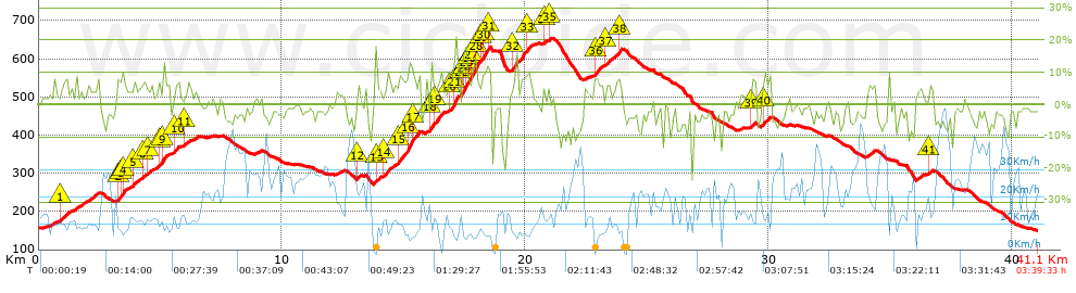
Distance in Km: 41.06
Climb in m: 945
IBP: 61 BYC

Near ...
Casabianca, Ciampino, Ciampino Aeroporto, Frattocchie, Marino, Santa Maria Delle Mole
Mario_Volpe
Author: Mario_Volpe
591 published routes

Add to my Group or Club

 Height in m      Climb in %      Speed in Km/h      Speed < 2 Km/h

Climbs > 5%

Climbs >5% Climbs >10% Climbs >15% Climbs >20% Climbs >25%
 Steep slope of 287 m.   Average slope  Distances  Download as waypoint
1
 Km 0.89  6%  287 m
 Steep slope of 376 m.  Average slope  Distances  Download as waypoint
2
 Km 3.247  8%  133 m
3
 Km 3.38  10%  103 m
4
 Km 3.483  7%  140 m
 Steep slope of 207 m.  Average slope  Distances  Download as waypoint
5
 Km 3.863  6%  207 m
 Steep slope of 137 m.  Average slope  Distances  Download as waypoint
6
 Km 4.242  6%  137 m
 Steep slope of 142 m.  Average slope  Distances  Download as waypoint
7
 Km 4.486  6%  142 m
 Steep slope of 279 m.  Average slope  Distances  Download as waypoint
8
 Km 4.938  6%  176 m
9
 Km 5.114  13%  103 m
 Steep slope of 209 m.  Average slope  Distances  Download as waypoint
10
 Km 5.554  7%  209 m
 Steep slope of 111 m.  Average slope  Distances  Download as waypoint
11
 Km 6.009  5%  111 m
 Steep slope of 105 m.  Average slope  Distances  Download as waypoint
12
 Km 13.096  6%  105 m
 Steep slope of 167 m.  Average slope  Distances  Download as waypoint
13
 Km 13.835  8%  167 m
 Steep slope of 302 m.  Average slope  Distances  Download as waypoint
14
 Km 14.181  7%  302 m
 Steep slope of 819 m.  Average slope  Distances  Download as waypoint
15
 Km 14.81  8%  367 m
16
 Km 15.178  14%  197 m
17
 Km 15.375  9%  255 m
 Steep slope of 407 m.  Average slope  Distances  Download as waypoint
18
 Km 16.111  13%  128 m
19
 Km 16.239  8%  279 m
 Steep slope of 374 m.  Average slope  Distances  Download as waypoint
20
 Km 16.816  5%  210 m
21
 Km 17.026  14%  164 m
 Steep slope of 751 m.  Average slope  Distances  Download as waypoint
22
 Km 17.363  7%  69 m
23
 Km 17.432  15%  33 m
24
 Km 17.465  16%  96 m
25
 Km 17.561  13%  67 m
26
 Km 17.628  8%  130 m
27
 Km 17.758  13%  257 m
28
 Km 18.015  7%  99 m
 Steep slope of 360 m.  Average slope  Distances  Download as waypoint
29
 Km 18.212  9%  99 m
30
 Km 18.312  12%  163 m
31
 Km 18.475  8%  98 m
 Steep slope of 430 m.  Average slope  Distances  Download as waypoint
32
 Km 19.479  8%  430 m
 Steep slope of 233 m.  Average slope  Distances  Download as waypoint
33
 Km 20.046  8%  233 m
 Steep slope of 105 m.  Average slope  Distances  Download as waypoint
34
 Km 20.727  7%  105 m
 Steep slope of 109 m.  Average slope  Distances  Download as waypoint
35
 Km 20.939  7%  109 m
 Steep slope of 366 m.  Average slope  Distances  Download as waypoint
36
 Km 22.831  7%  366 m
 Steep slope of 246 m.  Average slope  Distances  Download as waypoint
37
 Km 23.299  7%  246 m
 Steep slope of 100 m.  Average slope  Distances  Download as waypoint
38
 Km 23.848  12%  100 m
 Steep slope of 132 m.  Average slope  Distances  Download as waypoint
39
 Km 29.296  6%  132 m
 Steep slope of 282 m.  Average slope  Distances  Download as waypoint
40
 Km 29.755  6%  282 m
 Steep slope of 105 m.  Average slope  Distances  Download as waypoint
41
 Km 36.614  7%  105 m


Description of the route


Presence of ramps


 Climbs  Distance  % of the total  Speed  Your speed would be  Time  Your time would be
   15 - 30%  0.425  1.03  5.75  ?  0:04:26  ?
   10 - 15%  1.305  3.18  6.95  ?  0:11:16  ?
   5 - 10%  6.321  15.39  9.8  ?  0:38:42  ?
   1 - 5%  8.445  20.57  12.6  ?  0:40:13  ?
   Total*  16.496 Km  40.17 %  10.46 Km/h  ? Km/h    1:34:37 h  ? h  
 Flat
   1 - -1%  4.782 Km  11.64 %  16.86 Km/h  ? Km/h    0:17:01 h  ? h  
 Descents
   -1 - -5%  12.819  31.22  22.82  ?  0:33:42  ?
   -5 - -10%  5.042  12.28  22.27  ?  0:13:35  ?
   -10 - -15%  1.621  3.95  13.66  ?  0:07:07  ?
   -15 - -30%  0.306  0.74  9.33  ?  0:01:58  ?
   Total*  19.787 Km  48.19 %  21.06 Km/h  ? Km/h    0:56:22 h  ? h  
* The total has not necessarily coincide with the sum of the partials after correction of errors

How long would it take you?

How long would it take you to cover this route?
There are routes without a valid time information, but with your average stats you can assess the possible duration

Mario_Volpe to cover this route you've need a time of:   2:48:00 h 
If you sign in and have a minimum of two tracks of this same modality, you can know your time for this route, calculated from your stats..


¿Cuanto consumirá tu E-BIKE?

Entra tu E-IBP (formato n,nn)

E-IBP :   X 61 = 


 Detected activity type =  ()
 Penalization due to track conditions: 56 %   ( > 50 % = MTB, < 50 % = RDB)
 Reliability of the track: A   (945/74/0/-/-/74)
 Correction level applied to the track: 0
DIFFICULTY OF THE ROUTE
IBP = 61 BYC
According to your statistics
 Your time in motion would be: ? h
Your average speed would be: ? Km/h
 

 Total Distance: 41.06 Km
 Analysed distance: 41.06 Km
 Linear distance: 0.16 Km

 Cumulated positive ramps: 944.8 m  list of points info
 Cumulated negative ramps: 944.6 m
 Maximum height: 653.2 m
 Minimum height: 150.4 m
 Climbing Ratio: 5.73 %
 Descent ratio: 4.77 %
 Cumulated postive ramps per Km: 23.01 m
 Cumulated negative ramps per Km: 23.01 m

 Total time: 3:39:33 h
 Time in movement: 2:48:00 h
 According to your statistics
 Your time in motion would be: ? h  
 Stopped time: 0:51:33 h
 Maximum slope filter: ~30 %
 Minimum separation analysed: ~30 m
 Number of points: 3278   (cad. 12.53 m)
 Significant waypoints: 1162   (cad. 35.34 m / 35.45 %)

 Changes in direction per Km: 11.57
 Changes in direction > 5º por Km: 6.94
 Cumulated straight stretches: 10.065 Km
 Straight stretches per Km: 245.13 m
 Penalized slope changes: 9
 Penalized slope changes per Km: 0.219

 Average speed in total: 11.22 Km/h
 Average speed while moving: 14.66 Km/h
 According to your statistics
 Your average speed would be: ? Km/h  
 Maximum sustained speed: 54.2 Km/h


Comments

You can be the first one in commenting this route

 
My comments
:
Add comment  (Registered users)
 
Notify me answers to my comment  Do not notify answers to my comment


Share this route with a friend

Your friend will receive a message with a link to this page:
will see your email and your user name if you do it as registered user.


Write here your name (optional)

E-mail address of your friend(s). You can include various addresses separated by commas

Text or comment (optional) maximum 255 characters long, 255 Available characters

As a non registered users you need to fill-in the captcha text.
  Change image
Type the image characters.
 
 Share with a friend


Visited history

Delete history

Marked routes for review later or compare

My favorites


  Notify anomaly in this route Share in Facebook