El Berrueco

MTB
MTB
Ref..: 958026
Published: 02/05/2021
Performed: 02/05/2021
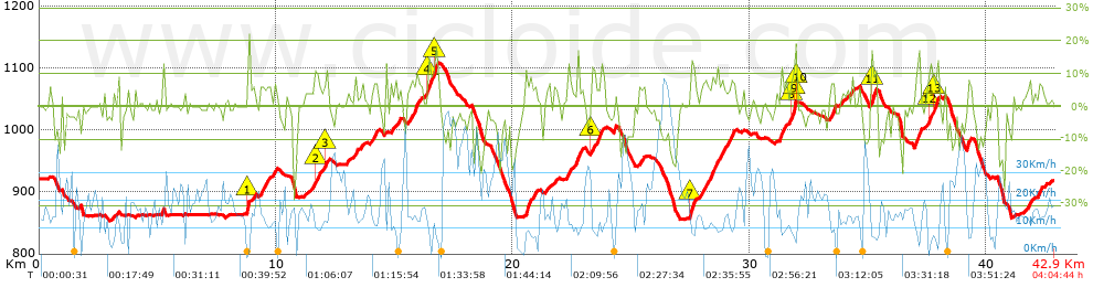
Distance in Km: 42.9
Climb in m: 1066
IBP: 84 BYC

Near ...
Berrueco, El, Dehesa De Santillana, Molino De Mazacortas, Sieteiglesias
Brujo1971
Author: Brujo1971
417 published routes

Add to my Group or Club

 Height in m      Climb in %      Speed in Km/h      Speed < 2 Km/h

Climbs > 5%

Climbs >5% Climbs >10% Climbs >15% Climbs >20% Climbs >25%
 Steep slope of 101 m.   Average slope  Distances  Download as waypoint
1
 Km 8.761  19%  101 m
 Steep slope of 112 m.  Average slope  Distances  Download as waypoint
2
 Km 9.018  6%  112 m
 Steep slope of 398 m.  Average slope  Distances  Download as waypoint
3
 Km 9.316  7%  398 m
 Steep slope of 176 m.  Average slope  Distances  Download as waypoint
4
 Km 9.853  7%  176 m
 Steep slope of 201 m.  Average slope  Distances  Download as waypoint
5
 Km 11.65  11%  132 m
6
 Km 11.782  7%  69 m
 Steep slope of 172 m.  Average slope  Distances  Download as waypoint
7
 Km 12.024  6%  69 m
8
 Km 12.093  11%  103 m
 Steep slope of 106 m.  Average slope  Distances  Download as waypoint
9
 Km 13.338  10%  106 m
 Steep slope of 273 m.  Average slope  Distances  Download as waypoint
10
 Km 14.001  7%  273 m
 Steep slope of 208 m.  Average slope  Distances  Download as waypoint
11
 Km 14.845  7%  208 m
 Steep slope of 536 m.  Average slope  Distances  Download as waypoint
12
 Km 15.584  7%  536 m
 Steep slope of 522 m.  Average slope  Distances  Download as waypoint
13
 Km 16.262  5%  143 m
14
 Km 16.405  12%  134 m
15
 Km 16.539  8%  103 m
16
 Km 16.642  13%  142 m
 Steep slope of 418 m.  Average slope  Distances  Download as waypoint
17
 Km 20.535  9%  418 m
 Steep slope of 187 m.  Average slope  Distances  Download as waypoint
18
 Km 21.376  6%  187 m
 Steep slope of 131 m.  Average slope  Distances  Download as waypoint
19
 Km 21.74  6%  131 m
 Steep slope of 163 m.  Average slope  Distances  Download as waypoint
20
 Km 22.288  9%  163 m
 Steep slope of 201 m.  Average slope  Distances  Download as waypoint
21
 Km 22.555  8%  201 m
 Steep slope of 105 m.  Average slope  Distances  Download as waypoint
22
 Km 22.863  6%  105 m
 Steep slope of 238 m.  Average slope  Distances  Download as waypoint
23
 Km 23.314  11%  137 m
24
 Km 23.451  5%  101 m
 Steep slope of 140 m.  Average slope  Distances  Download as waypoint
25
 Km 23.661  8%  140 m
 Steep slope of 169 m.  Average slope  Distances  Download as waypoint
26
 Km 25.335  6%  169 m
 Steep slope of 201 m.  Average slope  Distances  Download as waypoint
27
 Km 27.457  13%  201 m
 Steep slope of 951 m.  Average slope  Distances  Download as waypoint
28
 Km 27.938  8%  951 m
 Steep slope of 319 m.  Average slope  Distances  Download as waypoint
29
 Km 28.998  7%  319 m
 Steep slope of 236 m.  Average slope  Distances  Download as waypoint
30
 Km 31.29  9%  236 m
 Steep slope of 299 m.  Average slope  Distances  Download as waypoint
31
 Km 31.666  7%  139 m
32
 Km 31.806  11%  67 m
33
 Km 31.873  18%  62 m
34
 Km 31.935  19%  31 m
 Steep slope of 239 m.  Average slope  Distances  Download as waypoint
35
 Km 33.408  10%  239 m
 Steep slope of 105 m.  Average slope  Distances  Download as waypoint
36
 Km 34.296  7%  105 m
 Steep slope of 233 m.  Average slope  Distances  Download as waypoint
37
 Km 35.133  14%  163 m
38
 Km 35.297  7%  70 m
 Steep slope of 233 m.  Average slope  Distances  Download as waypoint
39
 Km 36.953  8%  33 m
40
 Km 36.985  8%  135 m
41
 Km 37.121  18%  65 m
 Steep slope of 240 m.  Average slope  Distances  Download as waypoint
42
 Km 37.4  5%  169 m
43
 Km 37.568  10%  71 m
 Steep slope of 262 m.  Average slope  Distances  Download as waypoint
44
 Km 37.741  9%  67 m
45
 Km 37.808  11%  133 m
46
 Km 37.942  10%  62 m
 Steep slope of 175 m.  Average slope  Distances  Download as waypoint
47
 Km 39.177  11%  175 m
 Steep slope of 214 m.  Average slope  Distances  Download as waypoint
48
 Km 41.721  7%  214 m
 Steep slope of 226 m.  Average slope  Distances  Download as waypoint
49
 Km 42.19  7%  226 m


Description of the route


Presence of ramps


 Climbs  Distance  % of the total  Speed  Your speed would be  Time  Your time would be
   15 - 30%  0.628  1.46  4.86  ?  0:07:45  ?
   10 - 15%  1.913  4.46  8.91  ?  0:12:53  ?
   5 - 10%  7.054  16.44  10.73  ?  0:39:26  ?
   1 - 5%  7.531  17.56  12.47  ?  0:36:14  ?
   Total*  17.125 Km  39.92 %  10.67 Km/h  ? Km/h    1:36:18 h  ? h  
 Flat
   1 - -1%  9.689 Km  22.59 %  12.52 Km/h  ? Km/h    0:46:25 h  ? h  
 Descents
   -1 - -5%  8.307  19.36  22.95  ?  0:21:43  ?
   -5 - -10%  4.014  9.36  29.61  ?  0:08:08  ?
   -10 - -15%  2.408  5.61  22.63  ?  0:06:23  ?
   -15 - -30%  1.355  3.16  14.39  ?  0:05:39  ?
   Total*  16.083 Km  37.49 %  23.04 Km/h  ? Km/h    0:41:53 h  ? h  
* The total has not necessarily coincide with the sum of the partials after correction of errors

How long would it take you?

How long would it take you to cover this route?
There are routes without a valid time information, but with your average stats you can assess the possible duration

Brujo1971 to cover this route you've need a time of:   3:04:36 h 
If you sign in and have a minimum of two tracks of this same modality, you can know your time for this route, calculated from your stats..


¿Cuanto consumirá tu E-BIKE?

Entra tu E-IBP (formato n,nn)

E-IBP :   X 84 = 


 Detected activity type =  ()
 Penalization due to track conditions: 74 %   ( > 50 % = MTB, < 50 % = RDB)
 Reliability of the track: B   (1066/66/0/-/-/66)
 Correction level applied to the track: 0
DIFFICULTY OF THE ROUTE
IBP = 84 BYC
According to your statistics
 Your time in motion would be: ? h
Your average speed would be: ? Km/h
 

 Total Distance: 42.9 Km
 Analysed distance: 42.9 Km
 Linear distance: 0.02 Km

 Cumulated positive ramps: 1066 m  list of points info
 Cumulated negative ramps: 1067.2 m
 Maximum height: 1108 m
 Minimum height: 853.2 m
 Climbing Ratio: 6.22 %
 Descent ratio: 6.64 %
 Cumulated postive ramps per Km: 24.85 m
 Cumulated negative ramps per Km: 24.88 m

 Total time: 4:04:44 h
 Time in movement: 3:04:36 h
 According to your statistics
 Your time in motion would be: ? h  
 Stopped time: 1:00:08 h
 Maximum slope filter: ~30 %
 Minimum separation analysed: ~30 m
 Number of points: 3076   (cad. 13.95 m)
 Significant waypoints: 1151   (cad. 37.27 m / 37.42 %)

 Changes in direction per Km: 11
 Changes in direction > 5º por Km: 7.97
 Cumulated straight stretches: 7.188 Km
 Straight stretches per Km: 167.55 m
 Penalized slope changes: 12
 Penalized slope changes per Km: 0.28

 Average speed in total: 10.52 Km/h
 Average speed while moving: 13.94 Km/h
 According to your statistics
 Your average speed would be: ? Km/h  
 Maximum sustained speed: 64.71 Km/h


Comments

You can be the first one in commenting this route

 
My comments
:
Add comment  (Registered users)
 
Notify me answers to my comment  Do not notify answers to my comment


Share this route with a friend

Your friend will receive a message with a link to this page:
will see your email and your user name if you do it as registered user.


Write here your name (optional)

E-mail address of your friend(s). You can include various addresses separated by commas

Text or comment (optional) maximum 255 characters long, 255 Available characters

As a non registered users you need to fill-in the captcha text.
  Change image
Type the image characters.
 
 Share with a friend


Visited history

Delete history

Marked routes for review later or compare

My favorites


  Notify anomaly in this route Share in Facebook