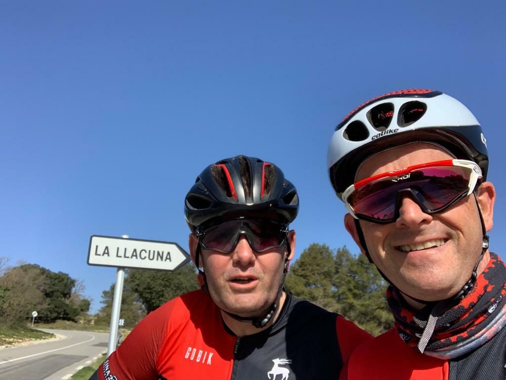
Salida con el capo hasta pontons____

Road
Road
Ref..: 948549
Published: 28/03/2021
Performed: 28/03/2021
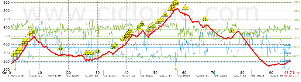
Distance in Km: 96.66
Climb in m: 1490
IBP: 90 BYC

Near ...
Can Roig (Cervello), Cervello, Corbera De Baix, Corbera De Llobregat, Costa De La Perdiu (Cervello), Inter-Club (Vallirana)
Antonio_Ruiz2
653 published routes

Add to my Group or Club

 Height in m      Climb in %      Speed in Km/h      Speed < 2 Km/h

Climbs > 5%

Climbs >5% Climbs >10% Climbs >15% Climbs >20% Climbs >25%
 Steep slope of 105 m.   Average slope  Distances  Download as waypoint
1
 Km 0.941  6%  105 m
 Steep slope of 112 m.  Average slope  Distances  Download as waypoint
2
 Km 1.832  6%  112 m
 Steep slope of 196 m.  Average slope  Distances  Download as waypoint
3
 Km 2.334  6%  196 m
 Steep slope of 130 m.  Average slope  Distances  Download as waypoint
4
 Km 2.824  5%  130 m
 Steep slope of 275 m.  Average slope  Distances  Download as waypoint
5
 Km 3.084  6%  275 m
 Steep slope of 330 m.  Average slope  Distances  Download as waypoint
6
 Km 4.15  6%  330 m
 Steep slope of 301 m.  Average slope  Distances  Download as waypoint
7
 Km 4.776  6%  301 m
 Steep slope of 697 m.  Average slope  Distances  Download as waypoint
8
 Km 5.209  8%  697 m
 Steep slope of 183 m.  Average slope  Distances  Download as waypoint
9
 Km 6.554  5%  183 m
 Steep slope of 247 m.  Average slope  Distances  Download as waypoint
10
 Km 7.485  6%  247 m
 Steep slope of 187 m.  Average slope  Distances  Download as waypoint
11
 Km 17.143  7%  187 m
 Steep slope of 291 m.  Average slope  Distances  Download as waypoint
12
 Km 26.026  7%  291 m
 Steep slope of 220 m.  Average slope  Distances  Download as waypoint
13
 Km 27.081  7%  220 m
 Steep slope of 193 m.  Average slope  Distances  Download as waypoint
14
 Km 28.048  7%  193 m
 Steep slope of 139 m.  Average slope  Distances  Download as waypoint
15
 Km 30.034  6%  139 m
 Steep slope of 103 m.  Average slope  Distances  Download as waypoint
16
 Km 35.351  6%  103 m
 Steep slope of 196 m.  Average slope  Distances  Download as waypoint
17
 Km 36.068  5%  196 m
 Steep slope of 190 m.  Average slope  Distances  Download as waypoint
18
 Km 38.626  6%  190 m
 Steep slope of 117 m.  Average slope  Distances  Download as waypoint
19
 Km 39.619  5%  117 m
 Steep slope of 111 m.  Average slope  Distances  Download as waypoint
20
 Km 39.84  5%  111 m
 Steep slope of 357 m.  Average slope  Distances  Download as waypoint
21
 Km 40.201  5%  357 m
 Steep slope of 267 m.  Average slope  Distances  Download as waypoint
22
 Km 40.74  5%  267 m
 Steep slope of 193 m.  Average slope  Distances  Download as waypoint
23
 Km 41.115  5%  193 m
 Steep slope of 162 m.  Average slope  Distances  Download as waypoint
24
 Km 44.196  6%  162 m
 Steep slope of 116 m.  Average slope  Distances  Download as waypoint
25
 Km 45.35  5%  116 m
 Steep slope of 455 m.  Average slope  Distances  Download as waypoint
26
 Km 47.63  6%  455 m
 Steep slope of 116 m.  Average slope  Distances  Download as waypoint
27
 Km 48.981  6%  116 m
 Steep slope of 293 m.  Average slope  Distances  Download as waypoint
28
 Km 50.924  6%  293 m
 Steep slope of 126 m.  Average slope  Distances  Download as waypoint
29
 Km 52.07  6%  126 m
 Steep slope of 123 m.  Average slope  Distances  Download as waypoint
30
 Km 53.355  7%  123 m
 Steep slope of 240 m.  Average slope  Distances  Download as waypoint
31
 Km 55.238  6%  240 m
 Steep slope of 356 m.  Average slope  Distances  Download as waypoint
32
 Km 55.953  5%  356 m
 Steep slope of 129 m.  Average slope  Distances  Download as waypoint
33
 Km 56.505  6%  129 m
 Steep slope of 112 m.  Average slope  Distances  Download as waypoint
34
 Km 57.155  6%  112 m
 Steep slope of 130 m.  Average slope  Distances  Download as waypoint
35
 Km 60.32  10%  130 m
 Steep slope of 192 m.  Average slope  Distances  Download as waypoint
36
 Km 67.046  6%  192 m
 Steep slope of 153 m.  Average slope  Distances  Download as waypoint
37
 Km 76.447  5%  153 m


Description of the route


Presence of ramps


 Climbs  Distance  % of the total  Speed  Your speed would be  Time  Your time would be
   15 - 30%  0.031  0.03  16.16  ?  0:00:07  ?
   10 - 15%  0.106  0.11  3.48  ?  0:01:50  ?
   5 - 10%  10.759  11.13  16.91  ?  0:38:11  ?
   1 - 5%  27.429  28.38  21.12  ?  1:17:55  ?
   Total*  38.325 Km  39.65 %  19.48 Km/h  ? Km/h    1:58:03 h  ? h  
 Flat
   1 - -1%  21.974 Km  22.73 %  29.41 Km/h  ? Km/h    0:44:50 h  ? h  
 Descents
   -1 - -5%  25.174  26.05  39.4  ?  0:38:20  ?
   -5 - -10%  10.854  11.23  44.35  ?  0:14:41  ?
   -10 - -15%  0.29  0.3  32.57  ?  0:00:32  ?
   -15 - -30%  0.039  0.04  34.75  ?  0:00:04  ?
   Total*  36.357 Km  37.61 %  40.68 Km/h  ? Km/h    0:53:37 h  ? h  
* The total has not necessarily coincide with the sum of the partials after correction of errors

How long would it take you?

How long would it take you to cover this route?
There are routes without a valid time information, but with your average stats you can assess the possible duration

Antonio_Ruiz2 to cover this route you've need a time of:   3:36:30 h 
If you sign in and have a minimum of two tracks of this same modality, you can know your time for this route, calculated from your stats..


¿Cuanto consumirá tu E-BIKE?

Entra tu E-IBP (formato n,nn)

E-IBP :   X 90 = 


 Detected activity type =  ()
 Penalization due to track conditions: 32 %   ( > 50 % = MTB, < 50 % = RDB)
 Reliability of the track: A   (1490/78/0/-/-/78)
 Correction level applied to the track: 0
DIFFICULTY OF THE ROUTE
IBP = 90 BYC
According to your statistics
 Your time in motion would be: ? h
Your average speed would be: ? Km/h
 

 Total Distance: 96.66 Km
 Analysed distance: 96.66 Km
 Linear distance: 40.71 Km

 Cumulated positive ramps: 1490.4 m  list of points info
 Cumulated negative ramps: 1453.4 m
 Maximum height: 827.6 m
 Minimum height: 144.8 m
 Climbing Ratio: 3.89 %
 Descent ratio: 4 %
 Cumulated postive ramps per Km: 15.42 m
 Cumulated negative ramps per Km: 15.04 m

 Total time: 3:50:21 h
 Time in movement: 3:36:30 h
 According to your statistics
 Your time in motion would be: ? h  
 Stopped time: 0:13:51 h
 Maximum slope filter: ~30 %
 Minimum separation analysed: ~30 m
 Number of points: 4124   (cad. 23.44 m)
 Significant waypoints: 2199   (cad. 43.95 m / 53.32 %)

 Changes in direction per Km: 6.63
 Changes in direction > 5º por Km: 4.19
 Cumulated straight stretches: 38.931 Km
 Straight stretches per Km: 402.76 m
 Penalized slope changes: 12
 Penalized slope changes per Km: 0.124

 Average speed in total: 25.18 Km/h
 Average speed while moving: 26.79 Km/h
 According to your statistics
 Your average speed would be: ? Km/h  
 Maximum sustained speed: 68.57 Km/h


Comments

You can be the first one in commenting this route

 
My comments
:
Add comment  (Registered users)
 
Notify me answers to my comment  Do not notify answers to my comment


Share this route with a friend

Your friend will receive a message with a link to this page:
will see your email and your user name if you do it as registered user.


Write here your name (optional)

E-mail address of your friend(s). You can include various addresses separated by commas

Text or comment (optional) maximum 255 characters long, 255 Available characters

As a non registered users you need to fill-in the captcha text.
  Change image
Type the image characters.
 
 Share with a friend


Visited history

Delete history

Marked routes for review later or compare

My favorites


  Notify anomaly in this route Share in Facebook