El Corredor - Castellvell - Ferrerons - Villalba Saserra

MTB
MTB
Ref..: 948302
Published: 28/03/2021
Performed: 27/03/2021
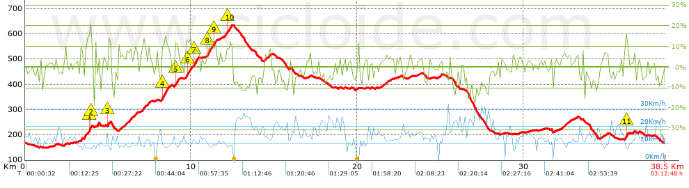
Distance in Km: 38.46
Climb in m: 964
IBP: 76 BYC

Guan
Author: Guan
339 published routes

Add to my Group or Club

 Height in m      Climb in %      Speed in Km/h      Speed < 2 Km/h

Climbs > 5%

Climbs >5% Climbs >10% Climbs >15% Climbs >20% Climbs >25%
 Steep slope of 136 m.   Average slope  Distances  Download as waypoint
1
 Km 3.344  9%  136 m
 Steep slope of 130 m.  Average slope  Distances  Download as waypoint
2
 Km 3.581  12%  130 m
 Steep slope of 307 m.  Average slope  Distances  Download as waypoint
3
 Km 3.746  6%  102 m
4
 Km 3.848  15%  101 m
5
 Km 3.949  21%  36 m
6
 Km 3.985  12%  68 m
 Steep slope of 138 m.  Average slope  Distances  Download as waypoint
7
 Km 4.227  5%  138 m
 Steep slope of 136 m.  Average slope  Distances  Download as waypoint
8
 Km 4.963  9%  33 m
9
 Km 4.996  10%  103 m
 Steep slope of 176 m.  Average slope  Distances  Download as waypoint
10
 Km 5.637  7%  176 m
 Steep slope of 410 m.  Average slope  Distances  Download as waypoint
11
 Km 5.945  7%  410 m
 Steep slope of 285 m.  Average slope  Distances  Download as waypoint
12
 Km 6.525  7%  285 m
 Steep slope of 270 m.  Average slope  Distances  Download as waypoint
13
 Km 7.021  9%  270 m
 Steep slope of 137 m.  Average slope  Distances  Download as waypoint
14
 Km 7.395  8%  137 m
 Steep slope of 501 m.  Average slope  Distances  Download as waypoint
15
 Km 8.193  9%  30 m
16
 Km 8.224  12%  401 m
17
 Km 8.625  7%  70 m
 Steep slope of 273 m.  Average slope  Distances  Download as waypoint
18
 Km 8.981  7%  35 m
19
 Km 9.016  11%  171 m
20
 Km 9.187  11%  67 m
 Steep slope of 800 m.  Average slope  Distances  Download as waypoint
21
 Km 9.638  9%  103 m
22
 Km 9.742  12%  245 m
23
 Km 9.987  7%  168 m
24
 Km 10.154  12%  137 m
25
 Km 10.291  10%  147 m
 Steep slope of 665 m.  Average slope  Distances  Download as waypoint
26
 Km 10.915  6%  36 m
27
 Km 10.95  12%  240 m
28
 Km 11.19  9%  177 m
29
 Km 11.367  10%  140 m
30
 Km 11.507  8%  72 m
 Steep slope of 517 m.  Average slope  Distances  Download as waypoint
31
 Km 11.952  8%  246 m
32
 Km 12.197  10%  136 m
33
 Km 12.333  10%  135 m
 Steep slope of 147 m.  Average slope  Distances  Download as waypoint
34
 Km 14.364  6%  147 m
 Steep slope of 172 m.  Average slope  Distances  Download as waypoint
35
 Km 14.624  7%  172 m
 Steep slope of 120 m.  Average slope  Distances  Download as waypoint
36
 Km 21.455  5%  120 m
 Steep slope of 130 m.  Average slope  Distances  Download as waypoint
37
 Km 21.686  6%  130 m
 Steep slope of 306 m.  Average slope  Distances  Download as waypoint
38
 Km 32.328  6%  306 m
 Steep slope of 206 m.  Average slope  Distances  Download as waypoint
39
 Km 36.043  5%  105 m
40
 Km 36.148  16%  101 m
 Steep slope of 104 m.  Average slope  Distances  Download as waypoint
41
 Km 36.568  7%  104 m


Description of the route


Presence of ramps


 Climbs  Distance  % of the total  Speed  Your speed would be  Time  Your time would be
   15 - 30%  0.403  1.05  8.06  ?  0:03:00  ?
   10 - 15%  2.181  5.67  9.63  ?  0:13:35  ?
   5 - 10%  4.958  12.89  11.46  ?  0:25:57  ?
   1 - 5%  9.71  25.24  12.76  ?  0:45:40  ?
   Total*  17.252 Km  44.85 %  11.74 Km/h  ? Km/h    1:28:12 h  ? h  
 Flat
   1 - -1%  4.015 Km  10.44 %  13.37 Km/h  ? Km/h    0:18:01 h  ? h  
 Descents
   -1 - -5%  9.433  24.52  16.36  ?  0:34:36  ?
   -5 - -10%  5.317  13.82  18.01  ?  0:17:43  ?
   -10 - -15%  2.159  5.61  18.07  ?  0:07:10  ?
   -15 - -30%  0.289  0.75  14.66  ?  0:01:11  ?
   Total*  17.197 Km  44.71 %  17.01 Km/h  ? Km/h    1:00:40 h  ? h  
* The total has not necessarily coincide with the sum of the partials after correction of errors

How long would it take you?

How long would it take you to cover this route?
There are routes without a valid time information, but with your average stats you can assess the possible duration

Guan to cover this route you've need a time of:   2:46:53 h 
If you sign in and have a minimum of two tracks of this same modality, you can know your time for this route, calculated from your stats..


¿Cuanto consumirá tu E-BIKE?

Entra tu E-IBP (formato n,nn)

E-IBP :   X 76 = 


 Detected activity type =  ()
 Penalization due to track conditions: 78 %   ( > 50 % = MTB, < 50 % = RDB)
 Reliability of the track: C   (964/56/0/-/-/56)
 Correction level applied to the track: 0
DIFFICULTY OF THE ROUTE
IBP = 76 BYC
According to your statistics
 Your time in motion would be: ? h
Your average speed would be: ? Km/h
 

 Total Distance: 38.46 Km
 Analysed distance: 38.46 Km
 Linear distance: 0.77 Km

 Cumulated positive ramps: 964.2 m  list of points info
 Cumulated negative ramps: 964 m
 Maximum height: 636.8 m
 Minimum height: 149.2 m
 Climbing Ratio: 5.59 %
 Descent ratio: 5.61 %
 Cumulated postive ramps per Km: 25.07 m
 Cumulated negative ramps per Km: 25.07 m

 Total time: 3:12:48 h
 Time in movement: 2:46:53 h
 According to your statistics
 Your time in motion would be: ? h  
 Stopped time: 0:25:55 h
 Maximum slope filter: ~30 %
 Minimum separation analysed: ~30 m
 Number of points: 3182   (cad. 12.09 m)
 Significant waypoints: 1080   (cad. 35.61 m / 33.94 %)

 Changes in direction per Km: 12.17
 Changes in direction > 5º por Km: 9.57
 Cumulated straight stretches: 5.047 Km
 Straight stretches per Km: 131.23 m
 Penalized slope changes: 8
 Penalized slope changes per Km: 0.208

 Average speed in total: 11.97 Km/h
 Average speed while moving: 13.83 Km/h
 According to your statistics
 Your average speed would be: ? Km/h  
 Maximum sustained speed: 33.15 Km/h


Comments

You can be the first one in commenting this route

 
My comments
:
Add comment  (Registered users)
 
Notify me answers to my comment  Do not notify answers to my comment


Share this route with a friend

Your friend will receive a message with a link to this page:
will see your email and your user name if you do it as registered user.


Write here your name (optional)

E-mail address of your friend(s). You can include various addresses separated by commas

Text or comment (optional) maximum 255 characters long, 255 Available characters

As a non registered users you need to fill-in the captcha text.
  Change image
Type the image characters.
 
 Share with a friend


Visited history

Delete history

Marked routes for review later or compare

My favorites


  Notify anomaly in this route Share in Facebook