El Ovni de Pineda con los electro-marcianos _

MTB
MTB
Ref..: 938131
Published: 18/02/2021
Performed: 17/02/2021
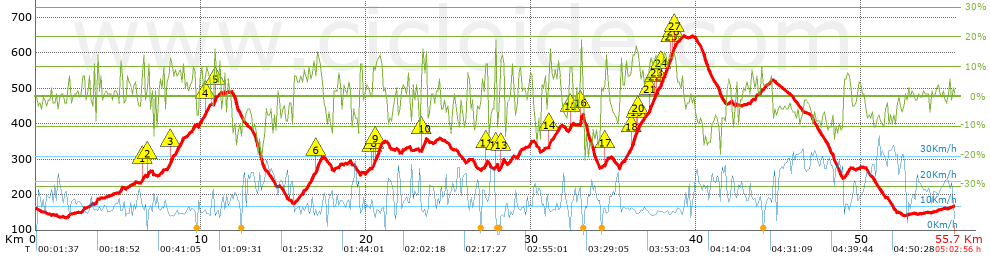
Distance in Km: 55.65
Climb in m: 1662
IBP: 128 BYC

Guan
Author: Guan
338 published routes

Add to my Group or Club

 Height in m      Climb in %      Speed in Km/h      Speed < 2 Km/h

Climbs > 10%

Climbs >5% Climbs >10% Climbs >15% Climbs >20% Climbs >25%
 Steep slope of 105 m.   Average slope  Distances  Download as waypoint
1
 Km 6.482  12%  105 m
 Steep slope of 103 m.  Average slope  Distances  Download as waypoint
2
 Km 6.803  12%  103 m
 Steep slope of 421 m.  Average slope  Distances  Download as waypoint
3
 Km 8.126  12%  193 m
4
 Km 10.264  12%  129 m
 Steep slope of 100 m.  Average slope  Distances  Download as waypoint
5
 Km 10.819  14%  100 m
 Steep slope of 200 m.  Average slope  Distances  Download as waypoint
6
 Km 16.97  13%  200 m
 Steep slope of 409 m.  Average slope  Distances  Download as waypoint
7
 Km 20.385  11%  101 m
8
 Km 20.486  12%  106 m
9
 Km 20.592  12%  308 m
 Steep slope of 214 m.  Average slope  Distances  Download as waypoint
10
 Km 23.39  11%  214 m
 Steep slope of 108 m.  Average slope  Distances  Download as waypoint
11
 Km 27.245  13%  108 m
 Steep slope of 97 m.  Average slope  Distances  Download as waypoint
12
 Km 27.823  17%  97 m
 Steep slope of 173 m.  Average slope  Distances  Download as waypoint
13
 Km 28.125  11%  173 m
 Steep slope of 101 m.  Average slope  Distances  Download as waypoint
14
 Km 31.06  13%  101 m
 Steep slope of 133 m.  Average slope  Distances  Download as waypoint
15
 Km 32.347  10%  133 m
 Steep slope of 145 m.  Average slope  Distances  Download as waypoint
16
 Km 32.966  20%  145 m
 Steep slope of 98 m.  Average slope  Distances  Download as waypoint
17
 Km 34.498  13%  98 m
 Steep slope of 1856 m.  Average slope  Distances  Download as waypoint
18
 Km 36.071  13%  276 m
19
 Km 36.347  16%  137 m
20
 Km 36.484  12%  68 m
21
 Km 37.126  12%  297 m
22
 Km 37.422  10%  103 m
23
 Km 37.525  13%  100 m
24
 Km 37.821  12%  675 m
25
 Km 38.496  15%  103 m
26
 Km 38.599  12%  101 m
27
 Km 38.7  11%  99 m


Description of the route


Presence of ramps


 Climbs  Distance  % of the total  Speed  Your speed would be  Time  Your time would be
   15 - 30%  0.836  1.5  8.85  ?  0:05:40  ?
   10 - 15%  4.691  8.43  8.67  ?  0:32:29  ?
   5 - 10%  9.491  17.05  9.83  ?  0:57:57  ?
   1 - 5%  10.356  18.61  11.62  ?  0:53:28  ?
   Total*  25.374 Km  45.6 %  10.18 Km/h  ? Km/h    2:29:34 h  ? h  
 Flat
   1 - -1%  5.135 Km  9.23 %  13.1 Km/h  ? Km/h    0:23:31 h  ? h  
 Descents
   -1 - -5%  10.657  19.15  17.68  ?  0:36:10  ?
   -5 - -10%  9.524  17.11  19.98  ?  0:28:36  ?
   -10 - -15%  3.625  6.51  19.03  ?  0:11:26  ?
   -15 - -30%  1.334  2.4  13.61  ?  0:05:53  ?
   Total*  25.142 Km  45.18 %  18.38 Km/h  ? Km/h    1:22:05 h  ? h  
* The total has not necessarily coincide with the sum of the partials after correction of errors

How long would it take you?

How long would it take you to cover this route?
There are routes without a valid time information, but with your average stats you can assess the possible duration

Guan to cover this route you've need a time of:   4:15:10 h 
If you sign in and have a minimum of two tracks of this same modality, you can know your time for this route, calculated from your stats..


¿Cuanto consumirá tu E-BIKE?

Entra tu E-IBP (formato n,nn)

E-IBP :   X 128 = 


 Detected activity type =  ()
 Penalization due to track conditions: 75 %   ( > 50 % = MTB, < 50 % = RDB)
 Reliability of the track: B   (1662/62/0/-/-/62)
 Correction level applied to the track: 0
DIFFICULTY OF THE ROUTE
IBP = 128 BYC
According to your statistics
 Your time in motion would be: ? h
Your average speed would be: ? Km/h
 

 Total Distance: 55.65 Km
 Analysed distance: 55.65 Km
 Linear distance: 0.77 Km

 Cumulated positive ramps: 1662.4 m  list of points info
 Cumulated negative ramps: 1658 m
 Maximum height: 647 m
 Minimum height: 135 m
 Climbing Ratio: 6.55 %
 Descent ratio: 6.59 %
 Cumulated postive ramps per Km: 29.87 m
 Cumulated negative ramps per Km: 29.79 m

 Total time: 5:02:56 h
 Time in movement: 4:15:10 h
 According to your statistics
 Your time in motion would be: ? h  
 Stopped time: 0:47:46 h
 Maximum slope filter: ~30 %
 Minimum separation analysed: ~30 m
 Number of points: 4538   (cad. 12.26 m)
 Significant waypoints: 1580   (cad. 35.22 m / 34.82 %)

 Changes in direction per Km: 12.83
 Changes in direction > 5º por Km: 10.75
 Cumulated straight stretches: 5.754 Km
 Straight stretches per Km: 103.4 m
 Penalized slope changes: 17
 Penalized slope changes per Km: 0.305

 Average speed in total: 11.02 Km/h
 Average speed while moving: 13.09 Km/h
 According to your statistics
 Your average speed would be: ? Km/h  
 Maximum sustained speed: 40.99 Km/h


Comments

You can be the first one in commenting this route

 
My comments
:
Add comment  (Registered users)
 
Notify me answers to my comment  Do not notify answers to my comment


Share this route with a friend

Your friend will receive a message with a link to this page:
will see your email and your user name if you do it as registered user.


Write here your name (optional)

E-mail address of your friend(s). You can include various addresses separated by commas

Text or comment (optional) maximum 255 characters long, 255 Available characters

As a non registered users you need to fill-in the captcha text.
  Change image
Type the image characters.
 
 Share with a friend


Visited history

Delete history

Marked routes for review later or compare

My favorites


  Notify anomaly in this route Share in Facebook