Argentona (Barcelona)

MTB
MTB
Ref..: 934487
Published: 01/02/2021
Performed: 31/01/2021
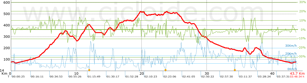
Distance in Km: 43.67
Climb in m: 928
IBP: 66 BYC

Tonif
Author: Tonif
89 published routes

Add to my Group or Club

 Height in m      Climb in %      Speed in Km/h      Speed < 2 Km/h

Climbs > 5%

Climbs >5% Climbs >10% Climbs >15% Climbs >20% Climbs >25%
 Steep slope of 169 m.   Average slope  Distances  Download as waypoint
1
 Km 4.296  8%  169 m
 Steep slope of 128 m.  Average slope  Distances  Download as waypoint
2
 Km 4.615  8%  128 m
 Steep slope of 370 m.  Average slope  Distances  Download as waypoint
3
 Km 4.956  7%  370 m
 Steep slope of 481 m.  Average slope  Distances  Download as waypoint
4
 Km 5.538  6%  279 m
5
 Km 5.817  13%  132 m
6
 Km 5.949  8%  70 m
 Steep slope of 169 m.  Average slope  Distances  Download as waypoint
7
 Km 6.206  8%  169 m
 Steep slope of 483 m.  Average slope  Distances  Download as waypoint
8
 Km 6.504  5%  65 m
9
 Km 6.57  11%  130 m
10
 Km 6.699  6%  288 m
 Steep slope of 383 m.  Average slope  Distances  Download as waypoint
11
 Km 7.12  7%  71 m
12
 Km 7.191  11%  136 m
13
 Km 7.327  8%  176 m
 Steep slope of 337 m.  Average slope  Distances  Download as waypoint
14
 Km 7.953  9%  337 m
 Steep slope of 611 m.  Average slope  Distances  Download as waypoint
15
 Km 10.185  6%  239 m
16
 Km 10.424  12%  300 m
17
 Km 10.724  10%  72 m
 Steep slope of 523 m.  Average slope  Distances  Download as waypoint
18
 Km 10.936  8%  215 m
19
 Km 11.151  13%  274 m
20
 Km 11.425  11%  34 m
 Steep slope of 135 m.  Average slope  Distances  Download as waypoint
21
 Km 11.633  9%  135 m
 Steep slope of 735 m.  Average slope  Distances  Download as waypoint
22
 Km 14.289  8%  735 m
 Steep slope of 131 m.  Average slope  Distances  Download as waypoint
23
 Km 15.823  6%  34 m
24
 Km 15.857  14%  97 m
 Steep slope of 34 m.  Average slope  Distances  Download as waypoint
25
 Km 16.059  16%  34 m
 Steep slope of 477 m.  Average slope  Distances  Download as waypoint
26
 Km 16.159  5%  32 m
27
 Km 16.192  5%  68 m
28
 Km 16.26  12%  239 m
29
 Km 16.499  6%  138 m
 Steep slope of 106 m.  Average slope  Distances  Download as waypoint
30
 Km 17.124  7%  106 m
 Steep slope of 104 m.  Average slope  Distances  Download as waypoint
31
 Km 18.722  8%  104 m
 Steep slope of 832 m.  Average slope  Distances  Download as waypoint
32
 Km 18.932  8%  832 m
 Steep slope of 309 m.  Average slope  Distances  Download as waypoint
33
 Km 23.297  8%  309 m
 Steep slope of 136 m.  Average slope  Distances  Download as waypoint
34
 Km 23.714  9%  136 m
 Steep slope of 262 m.  Average slope  Distances  Download as waypoint
35
 Km 35.5  13%  163 m
36
 Km 35.663  7%  99 m
 Steep slope of 176 m.  Average slope  Distances  Download as waypoint
37
 Km 36.683  6%  36 m
38
 Km 36.719  13%  105 m
39
 Km 36.824  9%  35 m
 Steep slope of 334 m.  Average slope  Distances  Download as waypoint
40
 Km 37.034  7%  196 m
41
 Km 37.23  14%  138 m


Description of the route


Presence of ramps


 Climbs  Distance  % of the total  Speed  Your speed would be  Time  Your time would be
   15 - 30%  0.131  0.3  4.9  ?  0:01:36  ?
   10 - 15%  2.371  5.43  5.87  ?  0:24:13  ?
   5 - 10%  5.429  12.43  7.24  ?  0:44:58  ?
   1 - 5%  9.029  20.67  10.49  ?  0:51:38  ?
   Total*  16.959 Km  38.83 %  8.31 Km/h  ? Km/h    2:02:25 h  ? h  
 Flat
   1 - -1%  6.857 Km  15.7 %  14.18 Km/h  ? Km/h    0:29:01 h  ? h  
 Descents
   -1 - -5%  12.288  28.14  18.8  ?  0:39:13  ?
   -5 - -10%  6.14  14.06  24.34  ?  0:15:08  ?
   -10 - -15%  1.314  3.01  21.7  ?  0:03:38  ?
   -15 - -30%  0.112  0.26  23.69  ?  0:00:17  ?
   Total*  19.854 Km  45.46 %  20.44 Km/h  ? Km/h    0:58:16 h  ? h  
* The total has not necessarily coincide with the sum of the partials after correction of errors

How long would it take you?

How long would it take you to cover this route?
There are routes without a valid time information, but with your average stats you can assess the possible duration

Tonif to cover this route you've need a time of:   3:29:42 h 
If you sign in and have a minimum of two tracks of this same modality, you can know your time for this route, calculated from your stats..


¿Cuanto consumirá tu E-BIKE?

Entra tu E-IBP (formato n,nn)

E-IBP :   X 66 = 


 Detected activity type =  ()
 Penalization due to track conditions: 62 %   ( > 50 % = MTB, < 50 % = RDB)
 Reliability of the track: B   (928/66/0/-/-/66)
 Correction level applied to the track: 0
DIFFICULTY OF THE ROUTE
IBP = 66 BYC
According to your statistics
 Your time in motion would be: ? h
Your average speed would be: ? Km/h
 

 Total Distance: 43.67 Km
 Analysed distance: 43.67 Km
 Linear distance: 0.04 Km

 Cumulated positive ramps: 927.8 m  list of points info
 Cumulated negative ramps: 920.2 m
 Maximum height: 526.2 m
 Minimum height: 66.2 m
 Climbing Ratio: 5.47 %
 Descent ratio: 4.63 %
 Cumulated postive ramps per Km: 21.25 m
 Cumulated negative ramps per Km: 21.07 m

 Total time: 3:48:34 h
 Time in movement: 3:29:42 h
 According to your statistics
 Your time in motion would be: ? h  
 Stopped time: 0:18:52 h
 Maximum slope filter: ~30 %
 Minimum separation analysed: ~30 m
 Number of points: 3293   (cad. 13.26 m)
 Significant waypoints: 1202   (cad. 36.33 m / 36.5 %)

 Changes in direction per Km: 12.37
 Changes in direction > 5º por Km: 9.02
 Cumulated straight stretches: 6.532 Km
 Straight stretches per Km: 149.58 m
 Penalized slope changes: 8
 Penalized slope changes per Km: 0.183

 Average speed in total: 11.46 Km/h
 Average speed while moving: 12.49 Km/h
 According to your statistics
 Your average speed would be: ? Km/h  
 Maximum sustained speed: 46.19 Km/h


Comments

You can be the first one in commenting this route

 
My comments
:
Add comment  (Registered users)
 
Notify me answers to my comment  Do not notify answers to my comment


Share this route with a friend

Your friend will receive a message with a link to this page:
will see your email and your user name if you do it as registered user.


Write here your name (optional)

E-mail address of your friend(s). You can include various addresses separated by commas

Text or comment (optional) maximum 255 characters long, 255 Available characters

As a non registered users you need to fill-in the captcha text.
  Change image
Type the image characters.
 
 Share with a friend


Visited history

Delete history

Marked routes for review later or compare

My favorites


  Notify anomaly in this route Share in Facebook