Boschi._...bagnati , freddini e nebbiosi....ma Belli..__

MTB
MTB
Ref..: 933824
Published: 30/01/2021
Performed: 29/01/2021
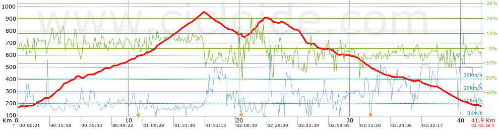
Distance in Km: 41.89
Climb in m: 1063
IBP: 73 BYC

Mario_Volpe
Author: Mario_Volpe
585 published routes

Add to my Group or Club

 Height in m      Climb in %      Speed in Km/h      Speed < 2 Km/h

Climbs > 5%

Climbs >5% Climbs >10% Climbs >15% Climbs >20% Climbs >25%
 Steep slope of 166 m.   Average slope  Distances  Download as waypoint
1
 Km 1.41  6%  166 m
 Steep slope of 176 m.  Average slope  Distances  Download as waypoint
2
 Km 1.674  6%  176 m
 Steep slope of 393 m.  Average slope  Distances  Download as waypoint
3
 Km 2.023  6%  393 m
 Steep slope of 255 m.  Average slope  Distances  Download as waypoint
4
 Km 2.773  6%  255 m
 Steep slope of 500 m.  Average slope  Distances  Download as waypoint
5
 Km 3.136  8%  234 m
6
 Km 3.371  10%  131 m
7
 Km 3.501  6%  135 m
 Steep slope of 430 m.  Average slope  Distances  Download as waypoint
8
 Km 3.773  12%  364 m
9
 Km 4.137  13%  66 m
 Steep slope of 211 m.  Average slope  Distances  Download as waypoint
10
 Km 4.375  6%  211 m
 Steep slope of 301 m.  Average slope  Distances  Download as waypoint
11
 Km 5.026  7%  108 m
12
 Km 5.134  11%  133 m
13
 Km 5.267  10%  60 m
 Steep slope of 272 m.  Average slope  Distances  Download as waypoint
14
 Km 5.937  7%  272 m
 Steep slope of 340 m.  Average slope  Distances  Download as waypoint
15
 Km 7.414  7%  340 m
 Steep slope of 202 m.  Average slope  Distances  Download as waypoint
16
 Km 8.386  7%  202 m
 Steep slope of 137 m.  Average slope  Distances  Download as waypoint
17
 Km 9.071  7%  137 m
 Steep slope of 135 m.  Average slope  Distances  Download as waypoint
18
 Km 9.688  5%  135 m
 Steep slope of 205 m.  Average slope  Distances  Download as waypoint
19
 Km 9.924  6%  205 m
 Steep slope of 280 m.  Average slope  Distances  Download as waypoint
20
 Km 10.489  7%  280 m
 Steep slope of 265 m.  Average slope  Distances  Download as waypoint
21
 Km 11.295  6%  200 m
22
 Km 11.495  9%  65 m
 Steep slope of 731 m.  Average slope  Distances  Download as waypoint
23
 Km 12.148  8%  208 m
24
 Km 12.356  12%  97 m
25
 Km 12.453  8%  426 m
 Steep slope of 961 m.  Average slope  Distances  Download as waypoint
26
 Km 12.975  6%  961 m
 Steep slope of 460 m.  Average slope  Distances  Download as waypoint
27
 Km 14.031  7%  460 m
 Steep slope of 762 m.  Average slope  Distances  Download as waypoint
28
 Km 14.595  7%  762 m
 Steep slope of 497 m.  Average slope  Distances  Download as waypoint
29
 Km 15.625  7%  497 m
 Steep slope of 488 m.  Average slope  Distances  Download as waypoint
30
 Km 16.218  8%  488 m
 Steep slope of 93 m.  Average slope  Distances  Download as waypoint
31
 Km 20.529  10%  93 m
 Steep slope of 95 m.  Average slope  Distances  Download as waypoint
32
 Km 20.719  10%  95 m
 Steep slope of 226 m.  Average slope  Distances  Download as waypoint
33
 Km 21.017  15%  226 m
 Steep slope of 459 m.  Average slope  Distances  Download as waypoint
34
 Km 21.376  8%  71 m
35
 Km 21.447  12%  134 m
36
 Km 21.581  16%  192 m
37
 Km 21.773  11%  62 m
 Steep slope of 174 m.  Average slope  Distances  Download as waypoint
38
 Km 22.062  10%  33 m
39
 Km 22.095  13%  141 m
 Steep slope of 130 m.  Average slope  Distances  Download as waypoint
40
 Km 23.636  6%  130 m


Description of the route


Presence of ramps


 Climbs  Distance  % of the total  Speed  Your speed would be  Time  Your time would be
   15 - 30%  0.481  1.15  5.1  ?  0:05:39  ?
   10 - 15%  1.524  3.64  6.96  ?  0:13:08  ?
   5 - 10%  8.1  19.34  8.61  ?  0:56:26  ?
   1 - 5%  7.648  18.26  11.53  ?  0:39:48  ?
   Total*  17.753 Km  42.38 %  9.26 Km/h  ? Km/h    1:55:01 h  ? h  
 Flat
   1 - -1%  4.953 Km  11.82 %  18.77 Km/h  ? Km/h    0:15:50 h  ? h  
 Descents
   -1 - -5%  10.311  24.61  16.5  ?  0:37:29  ?
   -5 - -10%  6.688  15.97  21.05  ?  0:19:04  ?
   -10 - -15%  1.71  4.08  15.43  ?  0:06:39  ?
   -15 - -30%  0.476  1.14  11.51  ?  0:02:29  ?
   Total*  19.186 Km  45.8 %  17.53 Km/h  ? Km/h    1:05:41 h  ? h  
* The total has not necessarily coincide with the sum of the partials after correction of errors

How long would it take you?

How long would it take you to cover this route?
There are routes without a valid time information, but with your average stats you can assess the possible duration

Mario_Volpe to cover this route you've need a time of:   3:16:32 h 
If you sign in and have a minimum of two tracks of this same modality, you can know your time for this route, calculated from your stats..


¿Cuanto consumirá tu E-BIKE?

Entra tu E-IBP (formato n,nn)

E-IBP :   X 73 = 


 Detected activity type =  ()
 Penalization due to track conditions: 62 %   ( > 50 % = MTB, < 50 % = RDB)
 Reliability of the track: B   (1063/68/0/-/-/68)
 Correction level applied to the track: 0
DIFFICULTY OF THE ROUTE
IBP = 73 BYC
According to your statistics
 Your time in motion would be: ? h
Your average speed would be: ? Km/h
 

 Total Distance: 41.89 Km
 Analysed distance: 41.89 Km
 Linear distance: 0 Km

 Cumulated positive ramps: 1063.4 m  list of points info
 Cumulated negative ramps: 1052.4 m
 Maximum height: 958.2 m
 Minimum height: 170.8 m
 Climbing Ratio: 5.99 %
 Descent ratio: 5.49 %
 Cumulated postive ramps per Km: 25.39 m
 Cumulated negative ramps per Km: 25.12 m

 Total time: 3:42:58 h
 Time in movement: 3:16:32 h
 According to your statistics
 Your time in motion would be: ? h  
 Stopped time: 0:26:26 h
 Maximum slope filter: ~30 %
 Minimum separation analysed: ~30 m
 Number of points: 3397   (cad. 12.33 m)
 Significant waypoints: 1196   (cad. 35.03 m / 35.21 %)

 Changes in direction per Km: 12.77
 Changes in direction > 5º por Km: 7.3
 Cumulated straight stretches: 12.267 Km
 Straight stretches per Km: 292.84 m
 Penalized slope changes: 6
 Penalized slope changes per Km: 0.143

 Average speed in total: 11.27 Km/h
 Average speed while moving: 12.79 Km/h
 According to your statistics
 Your average speed would be: ? Km/h  
 Maximum sustained speed: 54.42 Km/h


Comments

You can be the first one in commenting this route

 
My comments
:
Add comment  (Registered users)
 
Notify me answers to my comment  Do not notify answers to my comment


Share this route with a friend

Your friend will receive a message with a link to this page:
will see your email and your user name if you do it as registered user.


Write here your name (optional)

E-mail address of your friend(s). You can include various addresses separated by commas

Text or comment (optional) maximum 255 characters long, 255 Available characters

As a non registered users you need to fill-in the captcha text.
  Change image
Type the image characters.
 
 Share with a friend


Visited history

Delete history

Marked routes for review later or compare

My favorites


  Notify anomaly in this route Share in Facebook