Ruscall-LaMolina-ElSobirà-Pedró-Uix

MTB
MTB
Ref..: 929399
Published: 04/01/2021
Performed: 03/01/2021
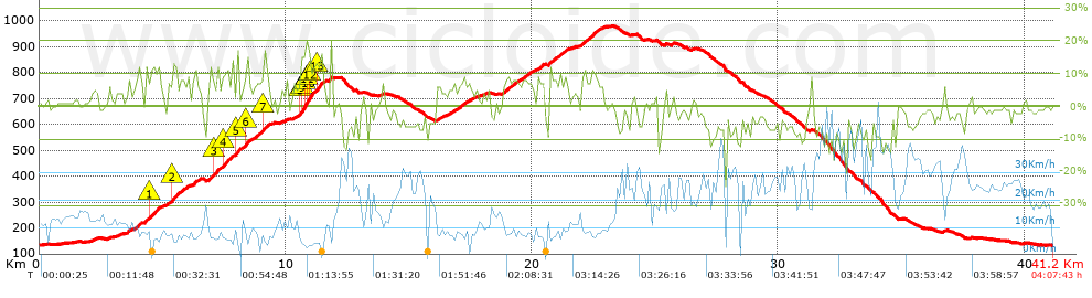
Distance in Km: 41.16
Climb in m: 1085
IBP: 77 BYC

canpeix
Author: canpeix
269 published routes

Add to my Group or Club

 Height in m      Climb in %      Speed in Km/h      Speed < 2 Km/h

Climbs > 5%

Climbs >5% Climbs >10% Climbs >15% Climbs >20% Climbs >25%
 Steep slope of 103 m.   Average slope  Distances  Download as waypoint
1
 Km 3.598  8%  103 m
 Steep slope of 241 m.  Average slope  Distances  Download as waypoint
2
 Km 3.883  7%  107 m
3
 Km 3.99  11%  134 m
 Steep slope of 643 m.  Average slope  Distances  Download as waypoint
4
 Km 4.269  8%  205 m
5
 Km 4.473  10%  237 m
6
 Km 4.71  10%  201 m
 Steep slope of 958 m.  Average slope  Distances  Download as waypoint
7
 Km 5.086  6%  272 m
8
 Km 5.358  11%  163 m
9
 Km 5.521  7%  523 m
 Steep slope of 270 m.  Average slope  Distances  Download as waypoint
10
 Km 6.25  9%  270 m
 Steep slope of 458 m.  Average slope  Distances  Download as waypoint
11
 Km 6.879  9%  198 m
12
 Km 7.077  10%  129 m
13
 Km 7.206  11%  131 m
 Steep slope of 426 m.  Average slope  Distances  Download as waypoint
14
 Km 7.445  9%  33 m
15
 Km 7.478  12%  200 m
16
 Km 7.678  9%  193 m
 Steep slope of 821 m.  Average slope  Distances  Download as waypoint
17
 Km 7.977  6%  37 m
18
 Km 8.015  17%  129 m
19
 Km 8.144  5%  216 m
20
 Km 8.359  13%  130 m
21
 Km 8.489  5%  103 m
22
 Km 8.592  6%  206 m
 Steep slope of 403 m.  Average slope  Distances  Download as waypoint
23
 Km 8.899  8%  208 m
24
 Km 9.106  11%  195 m
 Steep slope of 1110 m.  Average slope  Distances  Download as waypoint
25
 Km 10.505  7%  100 m
26
 Km 10.605  10%  33 m
27
 Km 10.638  17%  164 m
28
 Km 10.802  17%  94 m
29
 Km 10.896  16%  97 m
30
 Km 10.993  13%  131 m
31
 Km 11.124  8%  99 m
32
 Km 11.223  12%  191 m
33
 Km 11.414  8%  201 m
 Steep slope of 102 m.  Average slope  Distances  Download as waypoint
34
 Km 11.757  15%  102 m
 Steep slope of 172 m.  Average slope  Distances  Download as waypoint
35
 Km 16.135  7%  172 m
 Steep slope of 301 m.  Average slope  Distances  Download as waypoint
36
 Km 16.553  6%  301 m
 Steep slope of 534 m.  Average slope  Distances  Download as waypoint
37
 Km 16.954  7%  534 m
 Steep slope of 1192 m.  Average slope  Distances  Download as waypoint
38
 Km 18.8  7%  1192 m
 Steep slope of 298 m.  Average slope  Distances  Download as waypoint
39
 Km 20.219  8%  298 m
 Steep slope of 802 m.  Average slope  Distances  Download as waypoint
40
 Km 20.664  8%  802 m
 Steep slope of 917 m.  Average slope  Distances  Download as waypoint
41
 Km 22.009  8%  410 m
42
 Km 22.419  9%  97 m
43
 Km 22.516  7%  410 m


Description of the route


Presence of ramps


 Climbs  Distance  % of the total  Speed  Your speed would be  Time  Your time would be
   15 - 30%  0.645  1.57  5.29  ?  0:07:19  ?
   10 - 15%  2.041  4.96  6.92  ?  0:17:41  ?
   5 - 10%  7.509  18.25  8.7  ?  0:51:48  ?
   1 - 5%  7.039  17.1  12.24  ?  0:34:30  ?
   Total*  17.234 Km  41.87 %  9.29 Km/h  ? Km/h    1:51:18 h  ? h  
 Flat
   1 - -1%  6.161 Km  14.97 %  17.21 Km/h  ? Km/h    0:21:29 h  ? h  
 Descents
   -1 - -5%  7.977  19.38  22.35  ?  0:21:25  ?
   -5 - -10%  7.16  17.4  28.83  ?  0:14:54  ?
   -10 - -15%  2.18  5.3  25.4  ?  0:05:09  ?
   -15 - -30%  0.444  1.08  10.73  ?  0:02:29  ?
   Total*  17.761 Km  43.15 %  24.25 Km/h  ? Km/h    0:43:57 h  ? h  
* The total has not necessarily coincide with the sum of the partials after correction of errors

How long would it take you?

How long would it take you to cover this route?
There are routes without a valid time information, but with your average stats you can assess the possible duration

canpeix to cover this route you've need a time of:   2:56:44 h 
If you sign in and have a minimum of two tracks of this same modality, you can know your time for this route, calculated from your stats..


¿Cuanto consumirá tu E-BIKE?

Entra tu E-IBP (formato n,nn)

E-IBP :   X 77 = 


 Detected activity type =  ()
 Penalization due to track conditions: 56 %   ( > 50 % = MTB, < 50 % = RDB)
 Reliability of the track: A   (1085/82/0/-/-/82)
 Correction level applied to the track: 0
DIFFICULTY OF THE ROUTE
IBP = 77 BYC
According to your statistics
 Your time in motion would be: ? h
Your average speed would be: ? Km/h
 

 Total Distance: 41.16 Km
 Analysed distance: 41.16 Km
 Linear distance: 0.55 Km

 Cumulated positive ramps: 1085 m  list of points info
 Cumulated negative ramps: 1083 m
 Maximum height: 977.6 m
 Minimum height: 131.8 m
 Climbing Ratio: 6.3 %
 Descent ratio: 6.1 %
 Cumulated postive ramps per Km: 26.36 m
 Cumulated negative ramps per Km: 26.31 m

 Total time: 4:07:43 h
 Time in movement: 2:56:44 h
 According to your statistics
 Your time in motion would be: ? h  
 Stopped time: 1:10:59 h
 Maximum slope filter: ~30 %
 Minimum separation analysed: ~30 m
 Number of points: 2848   (cad. 14.45 m)
 Significant waypoints: 1114   (cad. 36.94 m / 39.12 %)

 Changes in direction per Km: 11.37
 Changes in direction > 5º por Km: 8.94
 Cumulated straight stretches: 6.597 Km
 Straight stretches per Km: 160.28 m
 Penalized slope changes: 7
 Penalized slope changes per Km: 0.17

 Average speed in total: 9.97 Km/h
 Average speed while moving: 13.97 Km/h
 According to your statistics
 Your average speed would be: ? Km/h  
 Maximum sustained speed: 54.72 Km/h


Comments

You can be the first one in commenting this route

 
My comments
:
Add comment  (Registered users)
 
Notify me answers to my comment  Do not notify answers to my comment


Share this route with a friend

Your friend will receive a message with a link to this page:
will see your email and your user name if you do it as registered user.


Write here your name (optional)

E-mail address of your friend(s). You can include various addresses separated by commas

Text or comment (optional) maximum 255 characters long, 255 Available characters

As a non registered users you need to fill-in the captcha text.
  Change image
Type the image characters.
 
 Share with a friend


Visited history

Delete history

Marked routes for review later or compare

My favorites


  Notify anomaly in this route Share in Facebook