Por la Valdorba y Guerinda. Nueve meses después

MTB
MTB
Ref..: 924449
Published: 13/12/2020
Performed: 13/12/2020
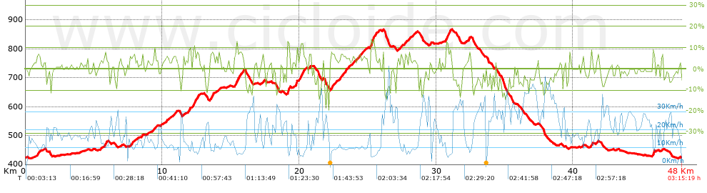
Distance in Km: 47.96
Climb in m: 1027
IBP: 65 BYC

ferover
Author: ferover
378 published routes

Add to my Group or Club

 Height in m      Climb in %      Speed in Km/h      Speed < 2 Km/h

Climbs > 5%

Climbs >5% Climbs >10% Climbs >15% Climbs >20% Climbs >25%
 Steep slope of 243 m.   Average slope  Distances  Download as waypoint
1
 Km 0.818  7%  243 m
 Steep slope of 184 m.  Average slope  Distances  Download as waypoint
2
 Km 5.752  8%  184 m
 Steep slope of 257 m.  Average slope  Distances  Download as waypoint
3
 Km 7.643  6%  257 m
 Steep slope of 194 m.  Average slope  Distances  Download as waypoint
4
 Km 10.782  6%  194 m
 Steep slope of 179 m.  Average slope  Distances  Download as waypoint
5
 Km 11.871  9%  179 m
 Steep slope of 512 m.  Average slope  Distances  Download as waypoint
6
 Km 12.226  8%  512 m
 Steep slope of 377 m.  Average slope  Distances  Download as waypoint
7
 Km 13.469  7%  377 m
 Steep slope of 118 m.  Average slope  Distances  Download as waypoint
8
 Km 14.091  7%  118 m
 Steep slope of 592 m.  Average slope  Distances  Download as waypoint
9
 Km 15.325  7%  58 m
10
 Km 15.383  12%  135 m
11
 Km 15.518  8%  399 m
 Steep slope of 214 m.  Average slope  Distances  Download as waypoint
12
 Km 19.131  13%  183 m
13
 Km 19.314  11%  31 m
 Steep slope of 477 m.  Average slope  Distances  Download as waypoint
14
 Km 19.774  8%  297 m
15
 Km 20.072  11%  180 m
 Steep slope of 132 m.  Average slope  Distances  Download as waypoint
16
 Km 20.741  7%  132 m
 Steep slope of 382 m.  Average slope  Distances  Download as waypoint
17
 Km 22.29  7%  382 m
 Steep slope of 602 m.  Average slope  Distances  Download as waypoint
18
 Km 22.983  6%  602 m
 Steep slope of 149 m.  Average slope  Distances  Download as waypoint
19
 Km 23.87  6%  149 m
 Steep slope of 235 m.  Average slope  Distances  Download as waypoint
20
 Km 24.289  6%  235 m
 Steep slope of 146 m.  Average slope  Distances  Download as waypoint
21
 Km 24.701  5%  146 m
 Steep slope of 459 m.  Average slope  Distances  Download as waypoint
22
 Km 25.176  12%  271 m
23
 Km 25.447  10%  188 m
 Steep slope of 179 m.  Average slope  Distances  Download as waypoint
24
 Km 27.379  6%  179 m
 Steep slope of 325 m.  Average slope  Distances  Download as waypoint
25
 Km 27.706  5%  325 m
 Steep slope of 416 m.  Average slope  Distances  Download as waypoint
26
 Km 30.729  13%  139 m
27
 Km 30.869  8%  277 m
 Steep slope of 115 m.  Average slope  Distances  Download as waypoint
28
 Km 32.358  8%  115 m
 Steep slope of 166 m.  Average slope  Distances  Download as waypoint
29
 Km 41.282  8%  166 m
 Steep slope of 209 m.  Average slope  Distances  Download as waypoint
30
 Km 45.805  9%  209 m


Description of the route


Presence of ramps


 Climbs  Distance  % of the total  Speed  Your speed would be  Time  Your time would be
   15 - 30%  0.12  0.25  6.43  ?  0:01:07  ?
   10 - 15%  1.152  2.4  7.2  ?  0:09:36  ?
   5 - 10%  6.722  14.02  9.72  ?  0:41:30  ?
   1 - 5%  13.942  29.07  13.5  ?  1:01:58  ?
   Total*  21.936 Km  45.74 %  11.53 Km/h  ? Km/h    1:54:11 h  ? h  
 Flat
   1 - -1%  7.776 Km  16.21 %  19.9 Km/h  ? Km/h    0:23:27 h  ? h  
 Descents
   -1 - -5%  9.479  19.76  21.45  ?  0:26:31  ?
   -5 - -10%  6.41  13.37  28.7  ?  0:13:24  ?
   -10 - -15%  2.1  4.38  31.77  ?  0:03:58  ?
   -15 - -30%  0.257  0.54  30.89  ?  0:00:30  ?
   Total*  18.247 Km  38.05 %  24.67 Km/h  ? Km/h    0:44:23 h  ? h  
* The total has not necessarily coincide with the sum of the partials after correction of errors

How long would it take you?

How long would it take you to cover this route?
There are routes without a valid time information, but with your average stats you can assess the possible duration

ferover to cover this route you've need a time of:   3:02:01 h 
If you sign in and have a minimum of two tracks of this same modality, you can know your time for this route, calculated from your stats..


¿Cuanto consumirá tu E-BIKE?

Entra tu E-IBP (formato n,nn)

E-IBP :   X 65 = 


 Detected activity type =  ()
 Penalization due to track conditions: 63 %   ( > 50 % = MTB, < 50 % = RDB)
 Reliability of the track: B   (1026/65/0/-/-/65)
 Correction level applied to the track: 0
DIFFICULTY OF THE ROUTE
IBP = 65 BYC
According to your statistics
 Your time in motion would be: ? h
Your average speed would be: ? Km/h
 

 Total Distance: 47.96 Km
 Analysed distance: 47.96 Km
 Linear distance: 0.01 Km

 Cumulated positive ramps: 1026.7 m  list of points info
 Cumulated negative ramps: 1030.2 m
 Maximum height: 867.2 m
 Minimum height: 420.6 m
 Climbing Ratio: 4.68 %
 Descent ratio: 5.65 %
 Cumulated postive ramps per Km: 21.41 m
 Cumulated negative ramps per Km: 21.48 m

 Total time: 3:15:19 h
 Time in movement: 3:02:01 h
 According to your statistics
 Your time in motion would be: ? h  
 Stopped time: 0:13:18 h
 Maximum slope filter: ~30 %
 Minimum separation analysed: ~30 m
 Number of points: 1444   (cad. 33.21 m)
 Significant waypoints: 910   (cad. 52.7 m / 63.02 %)

 Changes in direction per Km: 8.53
 Changes in direction > 5º por Km: 6.86
 Cumulated straight stretches: 4.854 Km
 Straight stretches per Km: 101.21 m
 Penalized slope changes: 9
 Penalized slope changes per Km: 0.188

 Average speed in total: 14.73 Km/h
 Average speed while moving: 15.81 Km/h
 According to your statistics
 Your average speed would be: ? Km/h  
 Maximum sustained speed: 48.16 Km/h


Comments

You can be the first one in commenting this route

 
My comments
:
Add comment  (Registered users)
 
Notify me answers to my comment  Do not notify answers to my comment


Share this route with a friend

Your friend will receive a message with a link to this page:
will see your email and your user name if you do it as registered user.


Write here your name (optional)

E-mail address of your friend(s). You can include various addresses separated by commas

Text or comment (optional) maximum 255 characters long, 255 Available characters

As a non registered users you need to fill-in the captcha text.
  Change image
Type the image characters.
 
 Share with a friend


Visited history

Delete history

Marked routes for review later or compare

My favorites


  Notify anomaly in this route Share in Facebook